Pacific Hurricane Season 2020
Earliest Tropical Depression on Record Forms in the East Pacific
April 25, 2020 Updated @7:12 PM EST
With about 20 days until the official start of the East Pacific Hurricane Season (May 15), we now have our first Tropical Depression off the west coast of Central America. An area of disturbance known as Invest 90E was designated a Tropical Depression earlier this afternoon with winds of 35 mph (approx. 56 km/h). This storm is now know as Tropical Depression One-E (TD 1E).
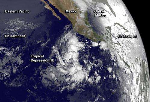
NOAA’s GOES-West satellite captured this infrared image of Tropical Depression 1E on May 23 at 8 a.m. EDT, less than 12 hours after developing in the Eastern Pacific. Credit: NASA/NOAA GOES Project.
The National Hurricane Center began issuing advisories on TD 1E and luckily it does not pose a threat to any land areas. However, it could further strengthen as it heads out west, further into the Pacific Ocean. If this were to occur it would be given the name “Amanda” and continue in the record books.
TD 1E was centered earlier this morning about 730 miles southwest of Cabo San Lucas, Mexico, and moving northwest at 7 mph. Top sustained winds were 35 mph.
Prior to TD 1E the earliest storm to form in the East Pacific was Tropical Storm Adrian on May 9, 2017, followed by Tropical Storm Alma on May 12, 1990. Comparing Tropical Storm Adrian to our current TD 1E, there is a difference of 14 days (2 weeks) regarding storm formation. Could we be seeing a trend in tropical systems forming earlier, outside of the designated hurricane season?
Each year the Pacific Hurricane Season begins May 15, however, we know that storms do not follow a “human-made” calendar system. Instead it relies on the right ingredients coming together at the right time. No matter where one is in the world a tropical system needs three ingredients in order to form and strengthen: Sea surface temperatures (SSTs) of 80°F (26.5°C); minimal atmospheric wind shear; and a disturbance that is already in place.
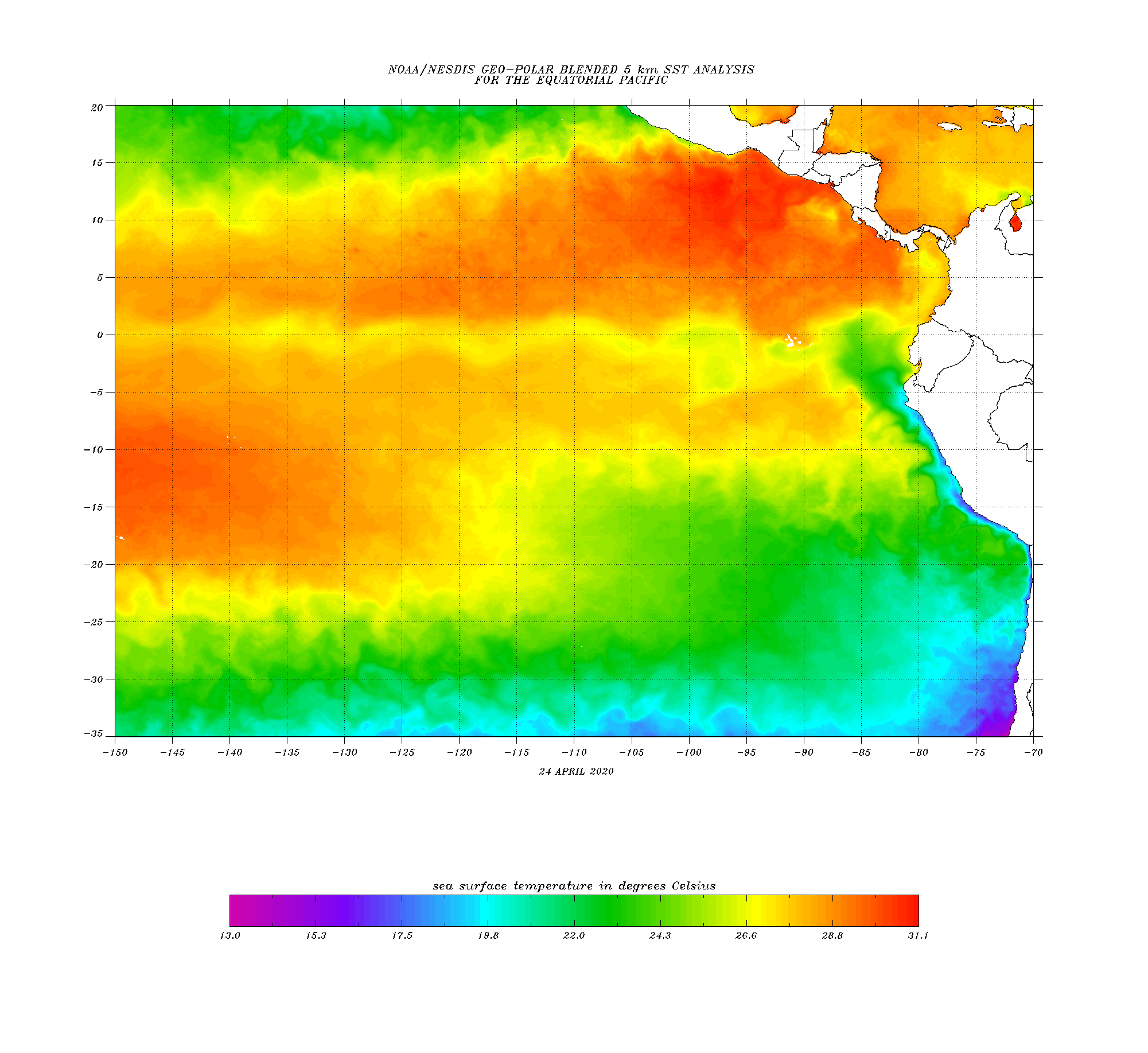
Current Sea Surface Temperatures in the East Pacific beginning April 24, 2020
First, looking at the SSTs off Central America we are experiencing above average temperatures for this time of the year and generally do not see warm temperatures like this until around June. Currently temperatures where TD 1E is located are between 28 and 31°C. More than warm enough for tropical activity to occur. However, notice the yellow and green “waves” coming off of northwestern South America, off the coast of Ecuador. They are cooler than the surrounding areas. This could be a sign of a forming La Niña in the Pacific. If this is the case this will benefit the Pacific Ocean as a whole, with regards to tropical cyclone activity. If a La Niña forms (which forecasters are watching closely) this generally decreases tropical cyclone frequency in the Pacific due to lowering of SSTs and increasing wind shear. However, this creates an opposite scenario in the Atlantic Basin. SSTs will rise and wind shear levels will decrease, creating an active period for the North Atlantic basin.
The current situation surround the La Niña formation is slow, and there is no guarantee that it will happen. Cooling and warming a large area of water takes time. It’s a process that can take months and even years until a large portion of the East Pacific, stretching to the West Pacific, can reach El Niño and La Niña status.
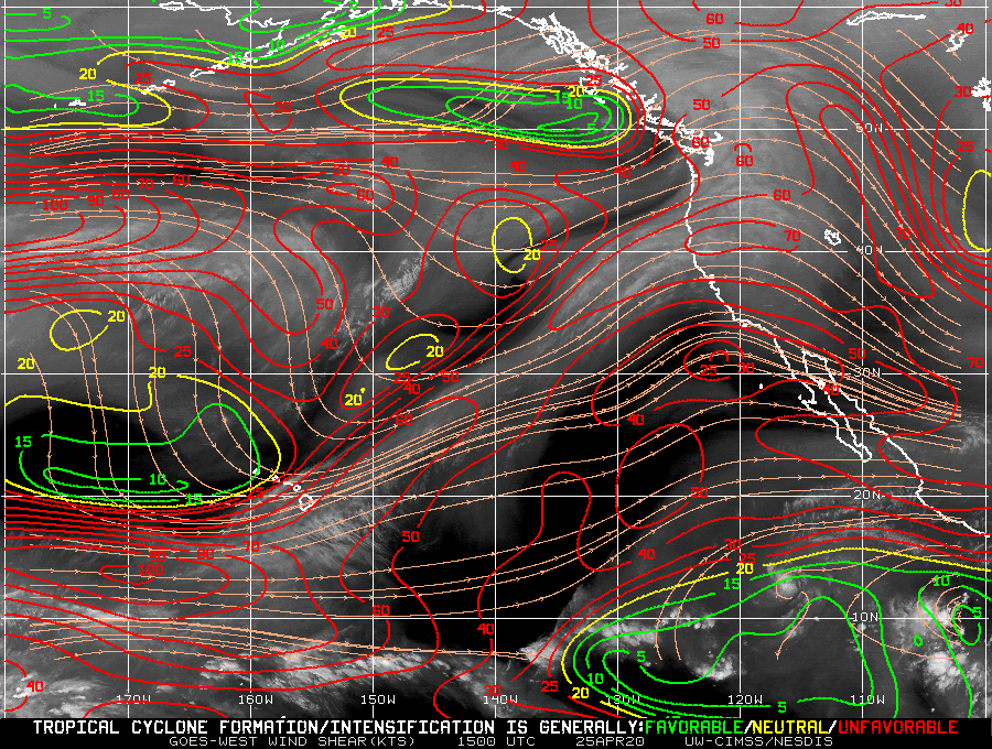
Current wind shear levels in the East Pacific. Red denotes unfavorable conditions for Tropical Cyclone formation and intensification compared to green and yellow which are favorable and neutral, respectively.
Wind shear levels are predominantly unfavorable throughout the East Pacific with only a small patch a favorable atmospheric conditions to the south. At this time TD 1E is taking advantage of this small area of wind shear. If it can continue to remain in this general area it has the potential to continue to grow and evolve into a Tropical Storm, which will occur once the winds are designated to be between 39 and 73 mph. TD 1E is only 4 mph shy of this.
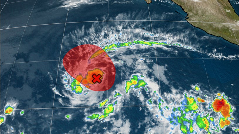
Current projected path of TD 1E, heading mostly NW out into the Pacific towards an unfavorable wind shear environment. The red area denotes a strong potential for the storm to strengthen in the next 12-24 hours.
The good news with TD 1E is that it will continue to head out to sea and weaken once it approaches an unfavorable shear environment. Most forecasts are calling for TD 1E to continue westward with the storm weakening. However, the possibility remains that there could be a very brief period the TD 1E could strengthen into a Tropical Storm.
Compared to the North Atlantic Basin, the East Pacific Basin has not been… tracked well… to say the least. Records regarding tropical development were not kept regularly and up-to-date for many years. It is understandable to a point. Most systems that form in the East Pacific track westward out into the open Pacific and usually fizzle without coming close to any land. While the season may not begin officially until May 15 there are those who question if the season should possibly start earlier. There is a lot of talk surrounding this topic with regards to the North Atlantic Basin which has seen an early start to the season (June 1st each year in the North Atlantic) for five consecutive years; 7 in the past decade. While there still needs to be more information and a well-recorded trend in the East Pacific it is a good time to discuss and suggest that maybe the hurricane season would need to be extended for the basin. Maybe all basins need to be extended. We could be looking at a hurricane season that is year-round, which is what occurs in the western Pacific. No one would want this, but the reality is that SSTs are rising in every ocean basin and this is a primary, probably the most important ingredient for a hurricane to form and strengthen. No matter what, each and every one of us should always be prepared and be prepared for the next tropical system to impact us; because there is always another storm on the horizon.