Atlantic Hurricane Season 2020
Laura and Marco, Battle Royale
Updated August 22, 2020 @ 12:57pm EST
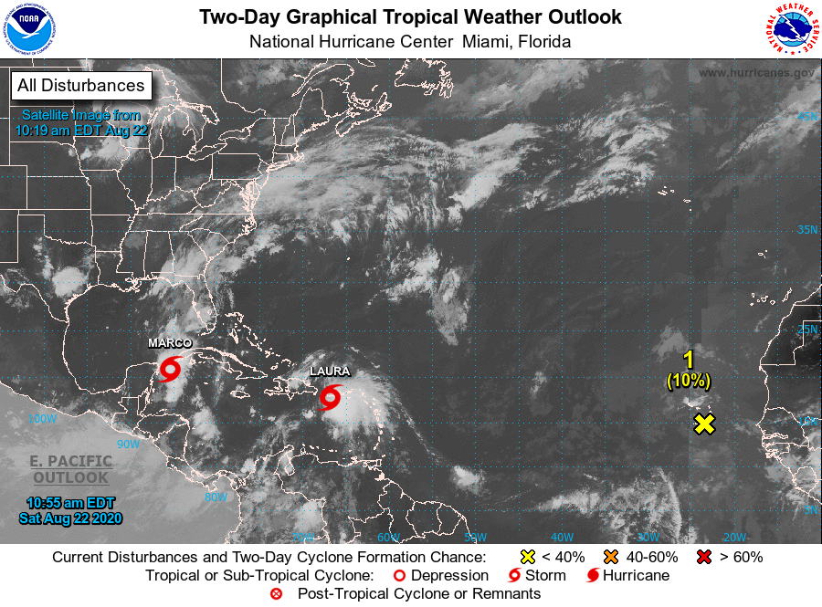
(Satellite view of Marco, Laura and a tropical wave coming off west Africa. Courtesy NHC)
2020 is certainly proving to be an odd and unique year in many ways and by midweek we may have a rare phenomenon take place in the Gulf of Mexico. We will get to that soon, but let’s focus on the two cyclones at play.
Tropical Storm Laura, at the time of this writing, is still struggling to organize with the heavy convection to the south in the Caribbean Sea. However, Hurricane Hunter data hows how much this storm is struggling.
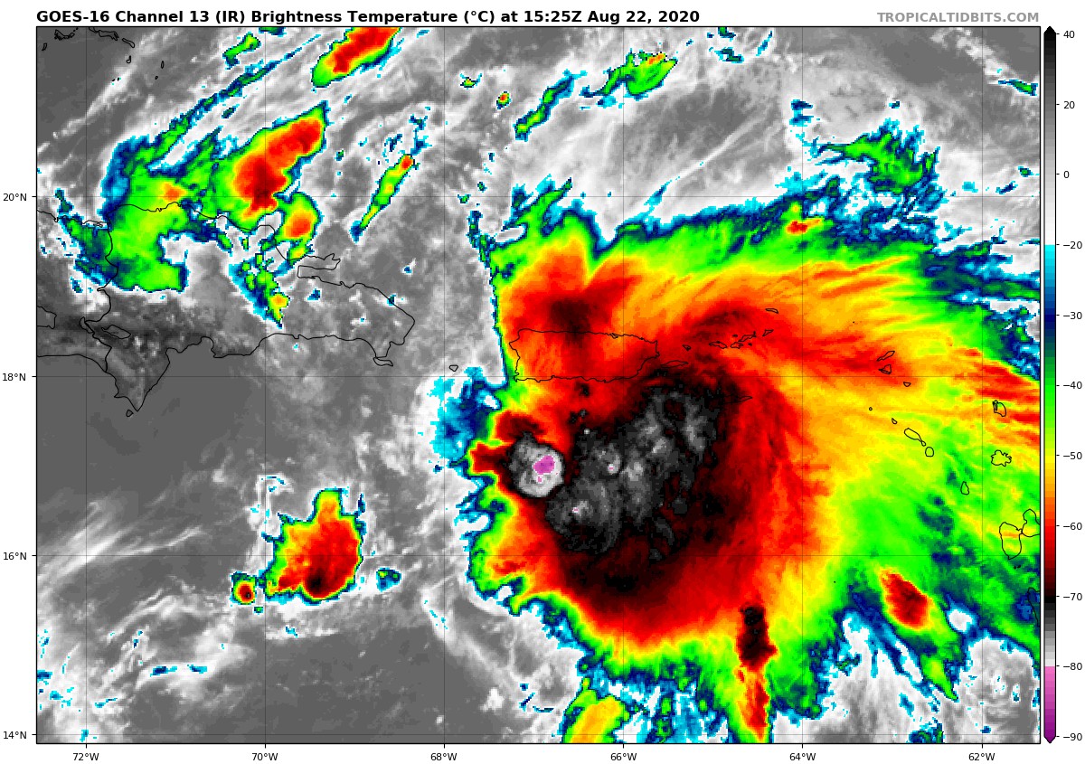
(August 22, 2020 view of Laura. Courtesy NOAA)
Maximum sustained wind speeds have only reached a maximum of 40 mph over the last several days and barometric pressure has only lowered down to 1006 mb (as of 11:00 AM advisory from the Hurricane Center; August 22, 2020).
Tropical storm conditions are expected across portions of the Virgin Islands and Puerto Rico for Saturday with parts of eastern Cuba anticipating these conditions Sunday. Fortunately for Florida the track of Laura has been shifting more and more south over the last few days with only a small portion of the Florida Keys remaining in the cone of uncertainty. This is not to say that extreme South Florida will not see any effects from Laura but the worst of the winds should remain to the south. However, heavy rainfall from Laura’s outerbands (this also depends on the size and shape of the storm) and gusty winds should still be expected. We may even see some Tropical Storm Watches be put into place over the next day or two as Laura continues westward.
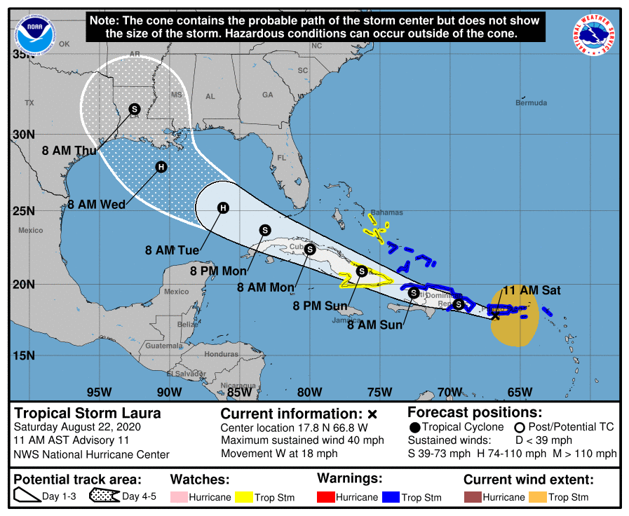
(August 22, 2020 11 AM advisory from NHC on Tropical Storm Laura)
The track of Laura does give some good news though, Laura has the chance of dissipating completely if the center of circulation tracks over the Great Antilles, especially Cuba. Even if Laura does not fully dissipate this land interaction will at least aid in keeping the storm weak before approaching the Gulf of Mexico late Monday.
However, this is when problems may arise, once Laura reaches the Gulf of Mexico. Ask any Gulf Coast resident and most will say that once a cyclone gets into the Gulf it can intensifying rapidly in just a few short hours. We have seen this many times with Hurricane Camille (1969), Hurricane Allen (1980), Hurricane Katrina (2005), and most recently, Hurricane Michael (2018). The Gulf of Mexico is a pool of warm tropical waters, which tropical cyclones love to feed off of, and so far sea surface temperatures (SSTs) are prime for further development.

(Current sea surface temperatures as of August 21, 2020)
Tropical cyclones require SSTs of at least 80°F (26.5°C) to form and continue to strengthen. At this time each area in the Gulf meets this requirement. Another ingredient that tropical cyclones need is minimal vertical wind shear, which allows for thunderstorms to continue to build into the upper layers of the atmosphere.
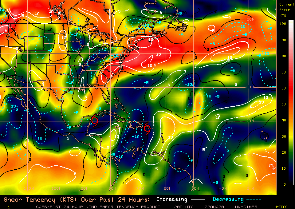
(Top image: current wind shear levels. Bottom image: forecast wind shear in the next 72 hours. Courtesy University of Wisconsin-Madison and WSI)
So far, the Gulf is not indicating a favorable environment with higher wind shear levels expected throughout the area. However, notice the second image which is predicting the shear levels in the next 72 hours, about the time frame when Laura is expected to start entering into the Gulf. Higher wind shear values begin to retreat northward opening up the Gulf of Mexico. So while, Laura may be struggling to intensify and organize it does have a very favorable environment if it makes it into the Gulf of Mexico. The best case scenario would be for the storm to dissipate and be sheared apart as a result of tracking over the Greater Antilles or at least weaken it considerably before it reached the Gulf of Mexico, because the longer this system spends over the Gulf, the better chance it has to rapidly intensify.
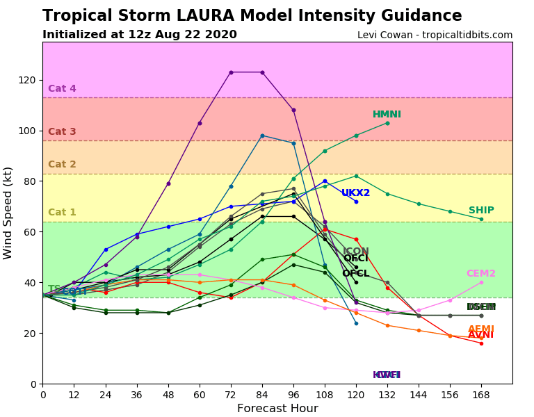
(Weather models focusing on the intensity of Tropical Storm Laura. Courtesy Levi Cowan; Tropical Tidbits)
The National Hurricane Center, as of August 22, 2020 is expected Laura to probably strengthen and become a Category 1 (maybe 2) hurricane early Tuesday and into Wednesday right over the central Gulf of Mexico as it continues to track towards Texas, Louisiana and Mississippi, possibly coming ashore late morning Wednesday or early afternoon before moving inland and quickly loosing strength. Other weather models are anticipating Laura to remain to remain at Tropical Storm strength at least until it reaches the Gulf. This is where models begin to diverge with some strengthening the storm to Category 1 and three taking it up to major hurricane strength (Cat 3+). While most models may still agree it could be a lower end hurricane there is still the chance Laura could intensify very quickly once it reaches the Gulf. All Gulf Coast residents need to monitor this system over the next few days, because things could go bad really fast with only a minimal amount of time to prepare. Make sure to review your hurricane plan and stock up, because we are now into the heart of hurricane season with August, September and October usually producing the majority of tropical cyclones.
However, we are not just monitoring Laura. We also have another cyclone threatening to enter into the Gulf of Mexico: Tropical Storm Marco. Unlike Laura approaching the Gulf from the east, Marco will be approaching from the south.

(August 22, 2020 Tropical Storm Marco. Courtesy NHC)
Compared to Laura, Marco is gaining strength much faster with maximum sustained wind speeds of 65 mph and a barometric pressure of 992mb. This storm will likely become a Category 1 hurricane by Saturday afternoon or evening as it approaches the Yucatan Channel.
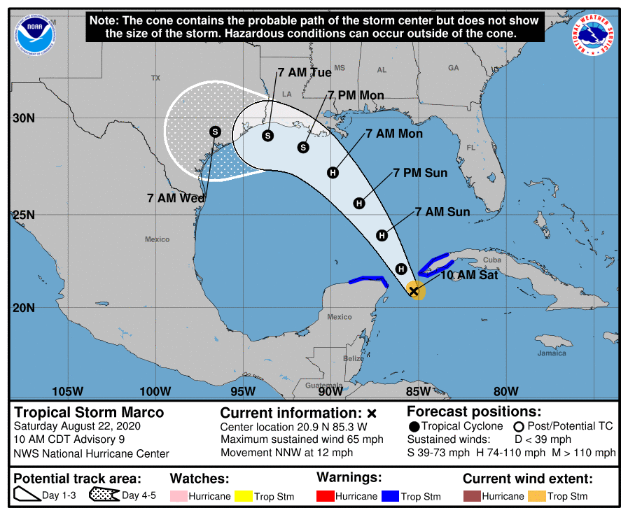
(August 22, 2020 11 AM advisory from NHC on Tropical Storm Marco)
Originally, Marco was forecast to cross over the Yucatan, but this slight shift to the east is just going to increase the chances of this storm intensifying fast because the center of circulation will remain over open water and those prime SSTs. Marco will continue northward spending most of its time over the Gulf waters from Sunday through Monday as it tracks towards Louisiana and then shifting more westward towards Texas, possibly degrading down to a Tropical Storm according to the National Hurricane Center, likely because of the land interaction to the north of the system. Similar to Laura, however, this system needs to be watched closely as it could also intensify rapidly. Marco may interact with higher levels of wind shear in the Gulf over the next couple of days since most of that heavy wind shear is not expected to depart the region until Monday or Tuesday. This could also help to keep Marco as a low end hurricane.
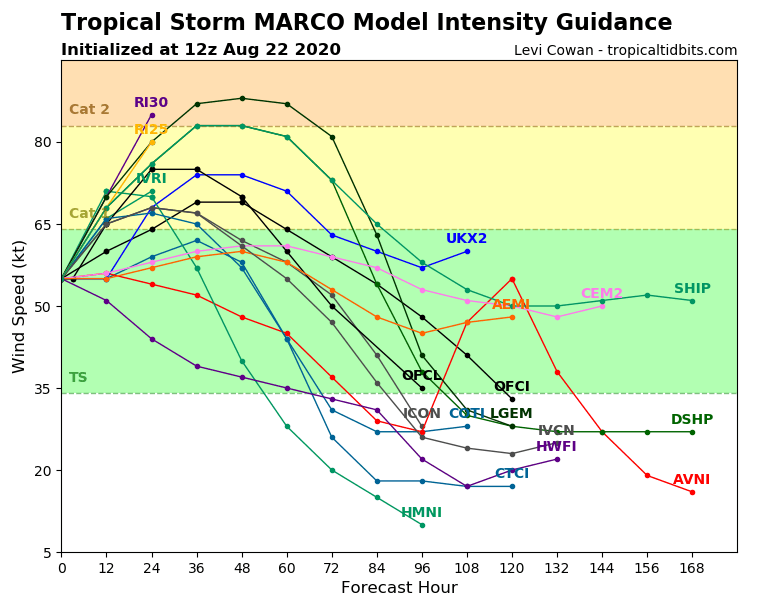
(Weather models focusing on the intensity of Tropical Storm Marco. Courtesy Levi Cowan; Tropical Tidbits)
Many weather models are agreeing that Marco has a good chance of reaching Category 1 strength in the next day or two with only a couple pushing it into the Category 2 range as it enters into the Gulf. However, as time progresses, the system is expected to weaken back to a Tropical Storm. Once again, think about the area this storm (and Laura) will enter. Laura may have a better chance as it will approach the Gulf after Marco avoiding most of the heavy vertical wind shear, but those SSTs could still provide ample amounts of fuel to a cyclone.
We now circle back to how unique this situation is: two tropical cyclones entering into a small area at almost the same time and possibly affecting one another. This will be a first for the Gulf of Mexico.
On Sept. 5, 1933 at 4UTC, 2 named storms made landfall along the Gulf Coast simultaneously: Cuba-Brownsville as a Cat. 3 #hurricane near Brownsville & Treasure Coast near Cedar Key as 55kt tropical storm. Here's the US Weather Bureau daily weather map (valid 8am ET) that day. pic.twitter.com/t6YNBipCDT
— Philip Klotzbach (@philklotzbach) August 20, 2020
In 1933 two hurricanes came close with one making landfall near Brownsville, TX and the other near Cedar Key, FL. There is little history recorded on this particular event, especially considering satellites were not in place. Therefore, this event could be a first, well documented, event on what could happen when we have two tropical systems, so close to one another and with similar strengths (lots of uncertainty keep in mind).
When two cyclones come in close contact with one another they could undergo what is known as a Fujiwhara Effect.
“When two hurricanes spinning in the same direction pass close enough to each other, they begin an intense dance around their common center. If one hurricane is a lot stronger than the other, the smaller one will orbit it and eventually come crashing into its vortex to be absorbed. Two storms closer in strength can gravitate towards each other until they reach a common point and merge, or merely spin each other around for a while before shooting off on their own paths. In rare occasions, the effect is additive when the hurricanes come together, resulting in one larger storm instead of two smaller ones” (NWS, 2020).
3) Iris vs Karen in 1995 — as they dance, Iris jogs eastward and Karen accelerates northward around Iris.
Oh, Luis and Humberto are in here too. 1995 was ridiculous until 2005 came along. (It was also the season that got me into hurricanes.) pic.twitter.com/mrhTlOtIGh
— Dr. Kim Wood (@DrKimWood) August 22, 2020
This has been recorded and absorbed several times in the Pacific and Atlantic Basins. Focusing on the Atlantic Basin: in 1995, Hurricane Iris absorbed nearby Karen and even helped to alter the path of Hurricane Luis just behind. Another example was Hurricane Wilma (2005), as it crossed over South Florida from the Gulf and exited into the Atlantic it absorbed smaller, and weaker, Tropical Storm Alpha.
This rare phenomenon is on the table for both Laura and Marco but once again, a lot of uncertainty remains. If these systems come close to one another, and they are of a similar strength they could orbit one another, feeding off the energy between them until one prevails and becomes the dominant storm. This could be a messy battle and of course alter the direction of these storms, which is why the exact track of both Laura and Marco have been “all over the place”. Another scenario is that this “epic battle royal” wont take place and the stronger storm would absorb the weaker one almost immediately. So lets say Marco maintains hurricane strength in the Gulf and Laura approaches. Laura, likely only a Tropical Storms or Tropical Depression, could come in close proximity to this storm and become absorbed into Marco. A third option is the stronger one will help to alter the path of the weaker storm. So if Marco is in the Gulf first it could wobble Laura to the north once it enters into the Gulf. Or Laura could be the storm to push Marco further westward (as evident of that shift in track as Marco approaches Louisiana late Monday). Finally, nothing could happen. Marco may be the favorable storm that enters into the Gulf, takes the energy from this area to help it strengthen leaving very little energy for Laura. SSTs may decrease beneath Marco due to all of the rain (this is also dependent on Marco’s size and shape) and Laura may struggle to intensify as it enters into the Gulf and fizzle, all of this considering if Laura survives going through the Greater Antilles.
This just goes to show the uncertainty of the situation. This is a new and interesting period for the meteorological community as well as all Gulf Coast residents. The one thing to take away from this is that we are now in the peak of hurricane season. Activity is just going to increase from this point on. Hurricane Isaias was Florida’s wakeup call for this year as it brushed close to the state before coming ashore in North Carolina. Hurricane Hanna was also the wake up call to the Gulf Coast coming ashore in South Texas as the first hurricane of the season. This is the time to prepare, be on guard, review your safety plan, and be ready for anything. Because that is what this is coming down to, anything could happen in the coming days as these two storms enter into the Gulf. Unfortunately, once a storm enters into the Gulf some place is going to be impacted.
Tropics are on Fire. Invest 92L: A Storm to Keep a Close Eye on.
Updated July 25, 2020 @ 4:55pm EST
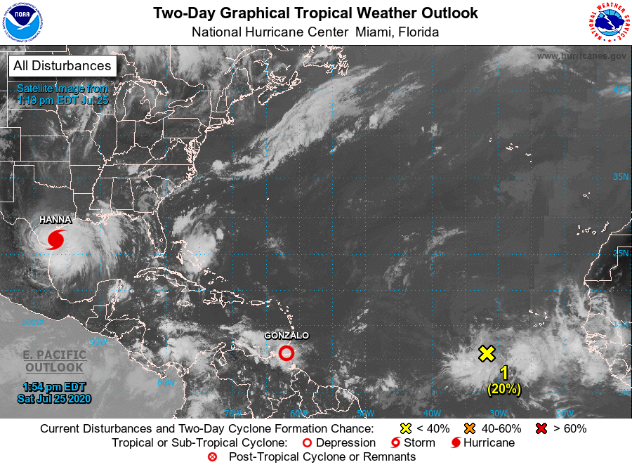
Current areas of interest in the North Atlantic Basin and over towards the Gulf of Mexico. Taken on July 25, 2020 (Courtesy of the National Hurricane Center).
Late July and already the tropics are catching fire. Hurricane Hanna, our first hurricane of the 2020 Atlantic Hurricane Season is quickly approaching the Texas coastline and will continue to move further inland over the Rio Grande Valley and towards northern Mexico.
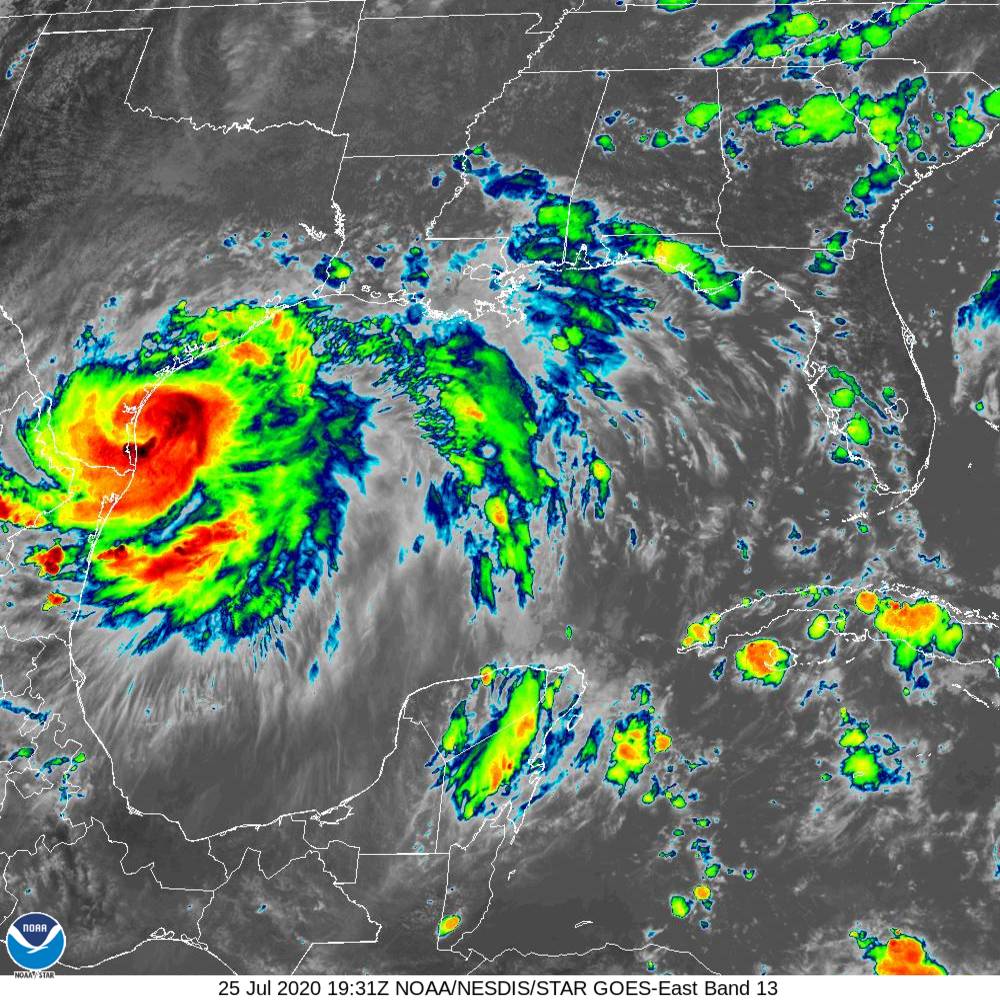
Hurricane Hanna, the first hurricane of the 2020 Atlantic Hurricane Season approaching the Texas Gulf Coast on July 25, 2020 (Courtesy NOAA).
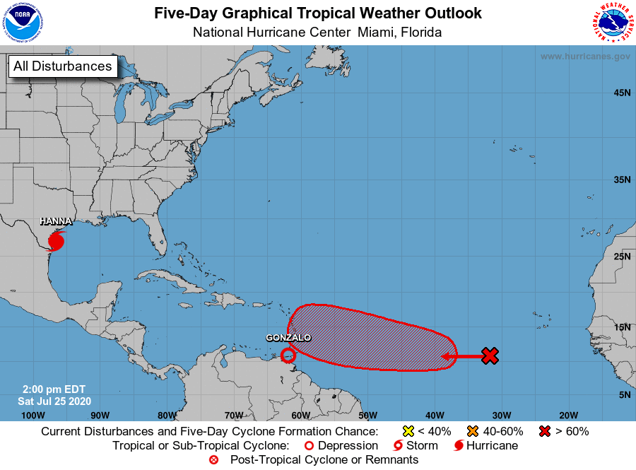
Elsewhere, Tropical Storm Gonzalo weakened back to a Tropical Depression on Saturday as it approached the southern Windward Islands. Nevertheless, heavy rains and gusty winds are expected to continue to fall across the small islands through Sunday and possibly into Monday. What was interesting about this particular storm was where is formed. A very tropical location close to the equator. Typically storms that develop in this area track directly westward and impact the Lesser Antilles before crossing into the Caribbean Sea. Gonzalo did track westward, for the most part, but it was so far south in latitude that it was bring some rain showers to parts of Venezuela, which does not typically happen. Most tropical cyclones keep their distance from South America and are generally far enough north that they do not bring any impacts to these areas. The good news is that Gonzalo will not be posing a threat for much longer to any Caribbean areas as it continues to weaken as it exits out into the Caribbean Sea.
Tropical Depression Gonzalo in the far south Windward Islands quickly weakening on July 25, 2020 (Courtesy NOAA).
The main topic of the week will be a large area of disturbed weather that is still days away from any landmass.
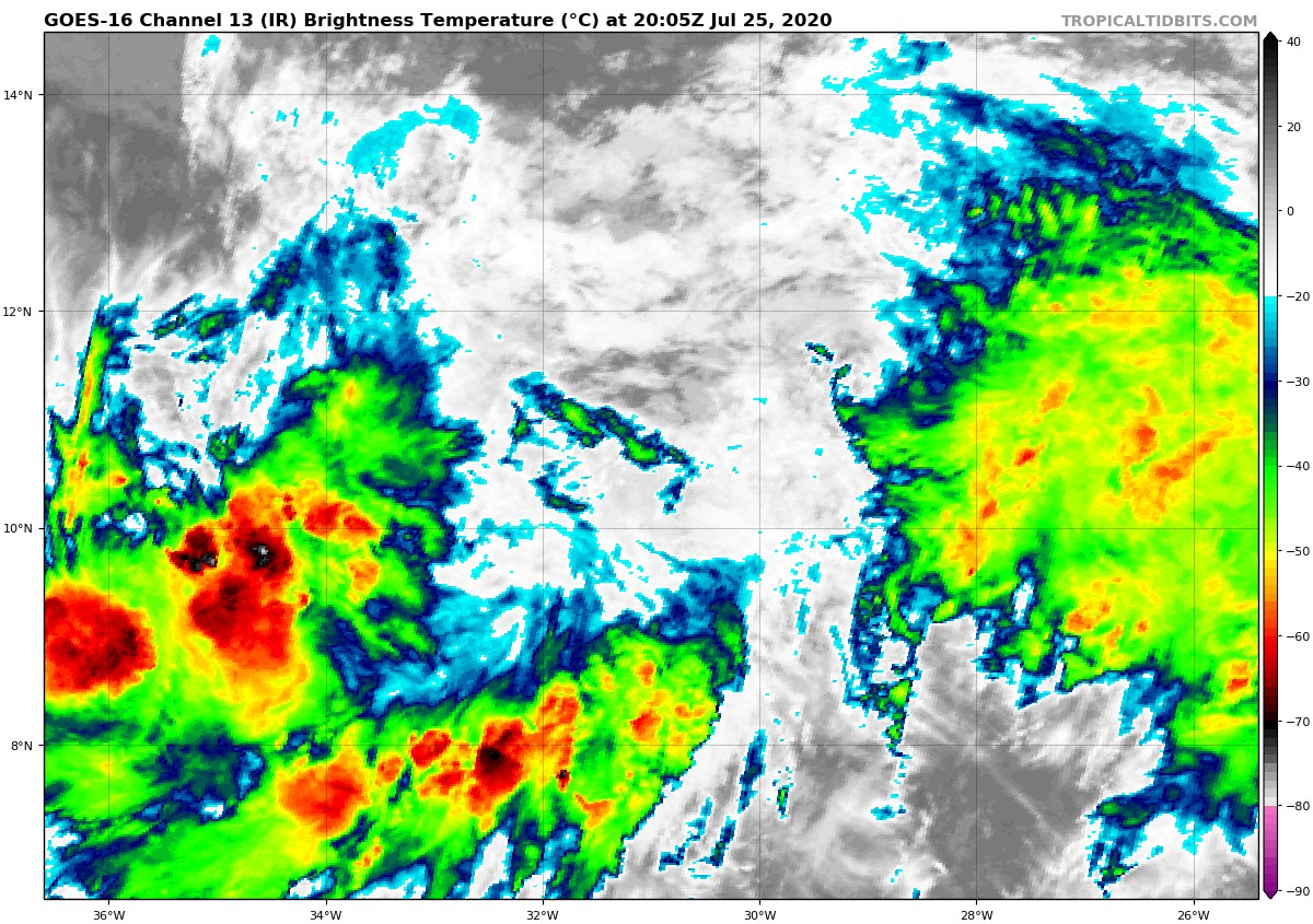
Invest 92L taken on July 25, 2020 off the west coast of Africa (Courtesy NOAA).
While it is not classified as a Tropical Depression it is still very impressive on satellite. The National Hurricane Center is currently referring to it as Invest 92L (an area under investigation).
This tropical wave began to come off the west coast of Africa Thursday and Friday and immediately started to take advantage of the warm sea surface temperatures (SSTs) and the open space far from any land mass areas. Once again, it is not a cyclone yet, but it is an area that forecasters have been watching the past few days and it has a very good chance of increasing in strength as it moves generally westward over the next several days. This is a perfect example of a Cape Verde Cyclone (even though it is not named yet) which are the ones that we should pay very close attention to. Cape Verde Cyclones develop near and around the Cape Verde Islands which lie just to the west of the African continent. These cyclones are formidable because they have ample amount of time to grow and intensify as they track towards the west and approach the Caribbean nations and the United States. An average hurricane season generally sees about 2-3 Cape Verde Cyclones, but given how active this year already is, we may be seeing a few more of these. Hurricane Hugo (1989), Hurricane Ivan (2004), and Hurricane Irma (2017) are three examples of Cape Verde Cyclones which caused massive destruction during their respected hurricanes seasons.
The National Hurricane Center at this time is giving this large cluster of showers and thunderstorms a 20% chance of development within the next 48 hours and a much higher, 70% chance, of development over the next 5 days, placing the storms around the central Tropical Atlantic, close to where Tropical Storm Gonzalo formed last week. Here is the main difference between Gonzalo and this upcoming storm though: latitude. Latitude is very important when it comes to development. Storms that form closer to the equator usually track due west and cross into the Caribbean Sea. However, further north in latitude and the track usually begins to pivot northward as the storm moves close to the continental United States. Usually colliding with some of the Greater Antilles. We are already anticipating this slight pivot northward by the time it gets to the central Atlantic but there is still the chance that it could track due west and push into the Caribbean.
Tropical activity in the North Atlantic as of the afternoon of July 25, 2020 and projections on intensification (Courtesy National Hurricane Center).
Weather models are starting to come into agreement with this pivot northward and this could make a few Floridians and southeast residents raise an eyebrow. I am not a fan of sharing models this far out as there are so many uncertainties, however, it is a good heads up to residents along the southeast United States that we are entering into the active part of the Hurricane Season (August through October) and conditions are likely just going to continue to get more active.
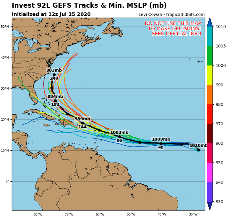
The first model we will look at is the American Model (GFS) and the estimated location and strength the storm could be around August 4, 2020. Keep in mind, all of these models are just estimates based on atmospheric conditions over the next several days, they are not solidified in stone and should not be used to make decisions at this time.
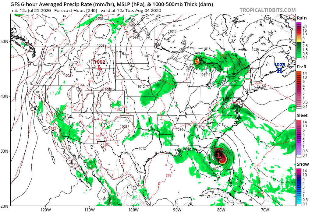
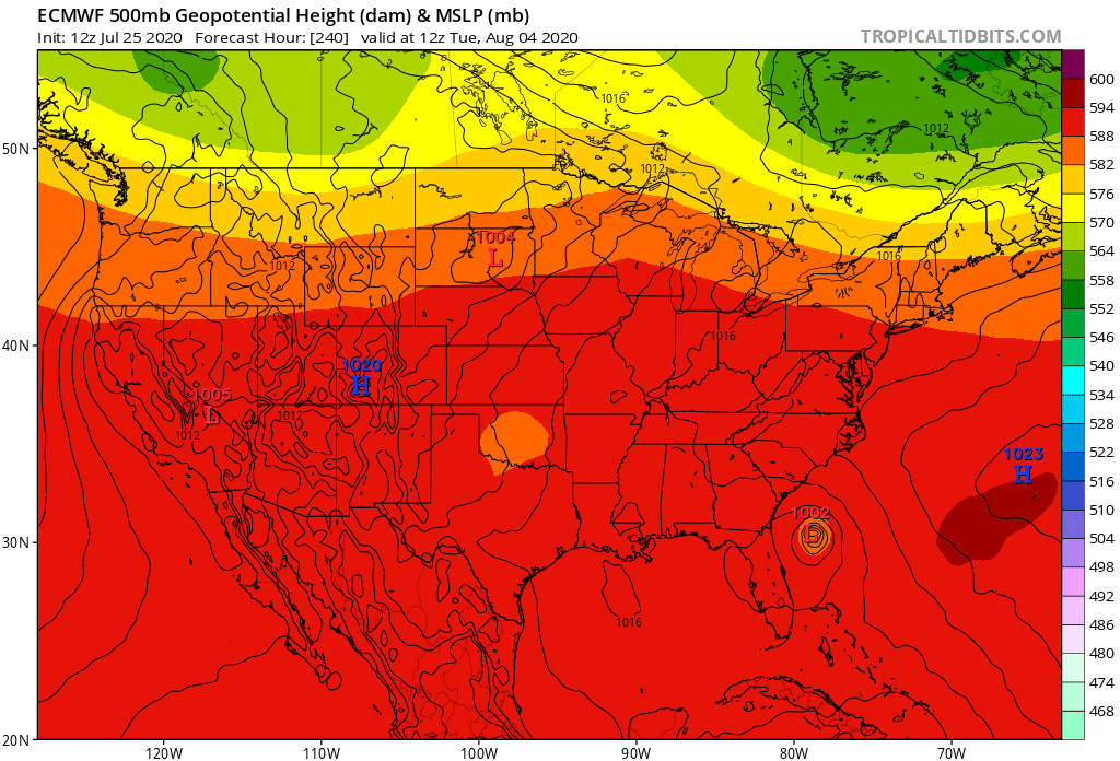
GFS model showing a FORECAST for August 4, 2020 and where Invest 92L MIGHT be, this is not to be used to make decisions and is only an ESTIMATE (this will be subject to change in the coming days as more information becomes available).
The GFS is so far anticipating a low pressure system with a barometric pressure of about 975mb (fairly strong hurricane typically on the Saffir-Simpson Hurricane Scale) impacting around the Space Coast or First Coast before traveling inland over North Florida and quickly pivoting away back towards the east over the southeast United States. This is not the whole story, if anything this is just a “nightmare” model that likes to cause fear.
Ensemble models for the GFS showing most of the projections staying offshore (these will be subject to change in the coming days as more information becomes available).
When we look at the ensemble models we see better news which show the majority of the tracks turning away from the State of Florida but still maintaining “decent” hurricane strength.
Another model we look at (and in recent years favor) is the European Model, which at this time shows some better news for August 4. Invest 92L is indeed expected to be strong and probably a hurricane but it is curving to the north staying away from the coast of Florida. This model will continue to project into the future with our next main concern being: will it turn completely back out to sea, or would the Carolinas be at risk? It will be a close call no matter what and even if it stays offshore, heavy surf and coastal flooding will be likely (all of this considering if the storm makes it to this point and is relatively strong).
Euro model showing a FORECAST for August 4, 2020 and where Invest 92L MIGHT be, this is not to be used to make decisions and is only an ESTIMATE (this will be subject to change in the coming days as more information becomes available).
All models available at this time are in agreement on one thing thought, Invest 92L will likely continue to strengthen over the next several days and could become a Category 1 hurricane in the 4-6 days.
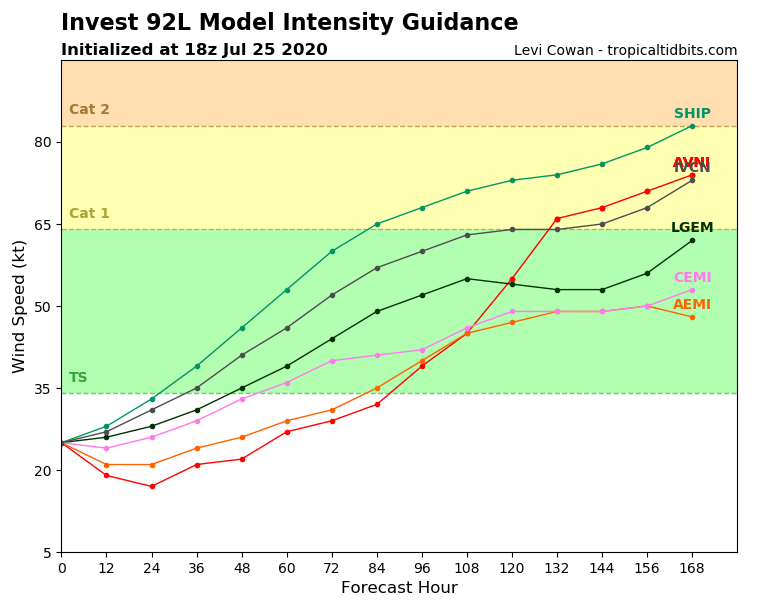
Estimated intensity of Invest 92L over the next 168 hours. This is not to be used to make decisions and is only an ESTIMATE (this will be subject to change in the coming days as more information becomes available).
This is very likely given how warm the sea surface temperatures are across the tropical Atlantic and the diminished wind shear in the higher layers of the atmosphere. Both of these favor tropical cyclones and allows them to intensify, sometimes quickly.
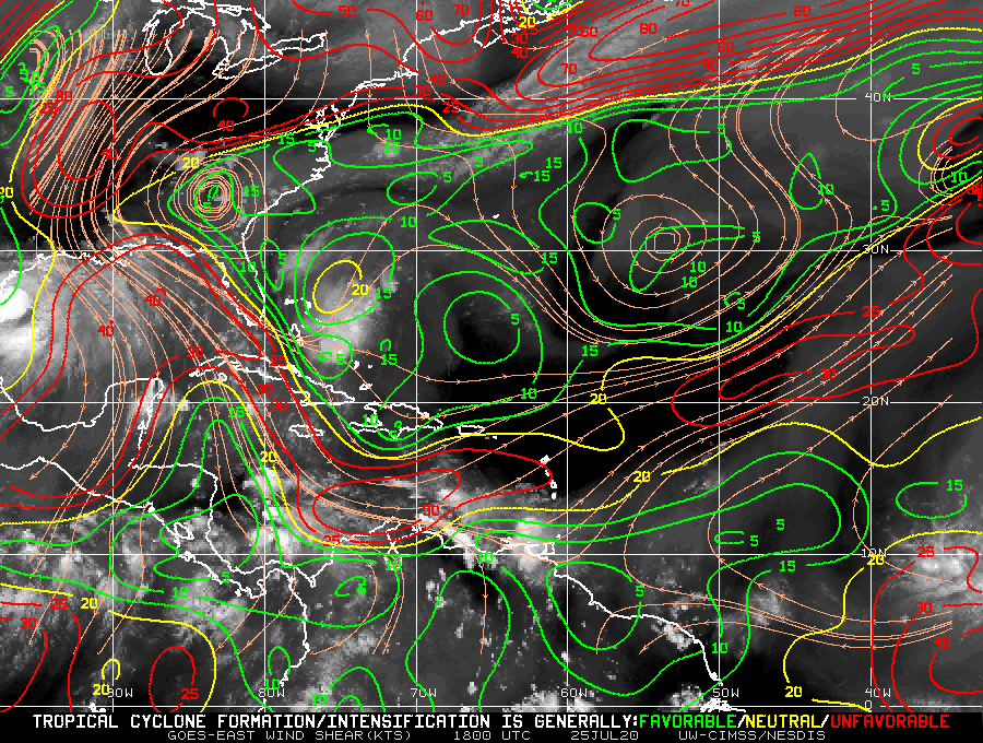
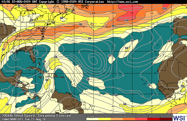
Wind shear levels across the North Atlantic Basin and the Gulf of Mexico. Red depicts high wind shear/not favorable for cyclone development. Blues and greens show favorable areas for potential development.
Aside from a patch of high wind shear (depicted in red) right where Invest 92L is currently located the rest of the tropical Atlantic remains “healthy” for cyclone formation. What will likely happen is Invest 92L will take advantage of this prime environment, quickly strengthen, and track westward before tilting slightly northward as it approaches the Lesser Antilles.
I cannot emphasize this enough, this is a storm that is still over a week away from any impact on the continental United States, but it is certainly one that we should keep an eye on given its location, impressive size and formation, and the fact that we are heading into the active hurricane season months.
Given the ongoing pandemic it is recommended that residents begin to stock up now ahead of this storm and not wait until the last minute. Whether this storm impacts a landmass or not, this is only the beginning of what is likely to be a very active hurricane season.