Severe Weather
There is a Nor’easter Freaking out the US and the Media
Updated January 20, 2016 at 8:23 pm EST
After days of news and Facebook posts circulating all of North America people are finally realizing that this weekend is the first big winter storm of the 2016 season. It has been a slow start to winter for most of us this year and many people are thankful for the warmer winter after the past two winter seasons many of us in the north experienced. However, there comes that time each season when the media hypes on about one big storm that will bury “insert state name” in record breaking snow and this causes everyone to go into a big Hollywood panic. For a week now meteorologists have been studying the weather models and many of these models are in agreement that a large and powerful nor’easter will form off the coast of the southeast United States and travel northward this coming weekend (January 22-24).
To start off, what is a nor’easter? To make this very simple it is a very large low pressure system found off the east coast of the United States during the winter time. These storms are referred to as “nor’easter” because of the direction of the wind. While on land the winds generally blow from the northeast. In one way we can think of these storms as giant winter hurricanes except the winds are much weaker compared to a hurricane. These systems are responsible for delivering blizzard conditions, heavy snowfall, coastal flooding, ice and heavy rains in the south for up to 2 days (depending on the forward speed of the system).
The Weather Channel (since 2012) has been naming major winter storms and nor’easter’s in an attempt to gain the public’s attention. They are referring to this nor’easter as “Winter Storm Jonas.” To make life easier, I too will be referring to this system as Jonas for the remainder of this post.
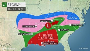
To begin let’s take a look at where Jonas is now. Jonas is currently over the central and southern Gulf states gathering strength and sounding alarms across many counties. Starting Thursday the Gulf states will be under a severe threat as Jonas’ south side (where the majority of the thunderstorms are taking place) moves eastward inching closer to the open waters of the Atlantic.
(Courtesy of AccuWeather)
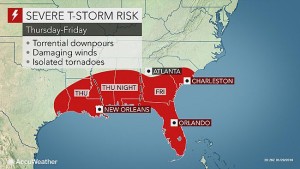
On Friday, Florida will be on high alert as this powerful low pressure system passes by and there is a high threat for a repeat of what Florida experienced a few days ago: tornadoes.
(Courtesy of AccuWeather)
Strong systems have battered Florida this winter season and a lot of it has to do with the warm temperatures the state has been seeing this year (yes, we all know Florida is warm, but this winter they have been warmer than usual). Isolated tornadoes will be possible through Friday as well as gusty winds and heavy thunderstorms as Jonas exits into the Atlantic Ocean and begins to intensify.
The whole process of a nor’easter forming has to do with what happens when the low pressure system reaches the Atlantic. Currently Jonas is not a nor’easter and will not become one until it hits water and gains fuel (very similar to a hurricane but cold air plays a bigger part in a nor’easter). Nor’easter’s tend to develop when there are contrasting air temperatures. Warm air coming up from the tropics interacts with cold Canadian air from the north. When the warm air from the south hits the cold air it is immediately carried upwards (warm air is less dense than cold) and cools causing heavy precipitation. As long as there is warm air being “fed” into the cold air, there will continue to be rain. Once the warm air runs out and completely cools the storm dissipates. Thanks to the warm air coming from the Gulf Stream (can usually travel all the way up the New England coast) nor’easters have plenty of fuel to cause destruction all the way up to Atlantic Canada.
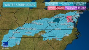
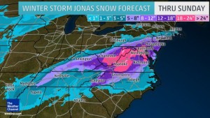
Forecasters and government agencies have already put up blizzard warnings across areas, especially in Maryland and Washington D.C., where snow values can reach as high as 2 feet, especially in the mountains. Some places may eve experience up to 3 feet of snow. These accumulations are forecasted to be in the mountains of West Virginia and the east coast of Pennsylvania.
(Courtesy of the Weather Channel)
However, I need to remind everyone of what happened in 2015. Anyone remember the Blizzapocalypsegeddon 2015? The storm that was supposed to be the “end of the world” because of so much snow that will fall in the New York area… and then barely anything happened… and a lot of governments and meteorologists had to go and apologize to the public afterwards? yea… that one. I am going to be honest with you all right now. Nor’easter’s are like hurricanes, super hard to forecast and predict the exact amount of precipitation. We currently don’t have the technology to tell us how much rain/snow is in a cloud system. We have estimates, but not precise values (this is what makes my research so hard). In the case of a nor’easter all that anyone wants to know is how much snow we are going to get. In a hurricane it is mostly the wind (which we have decent technology to forecast). Therefore, as meteorologists, we are helpless when it comes to forecasting nor’easter’s and their precipitation compared to hurricanes and their wind speed… sorry.
So here is the conclusion. Virginia, Maryland, West Virginia, Washington D.C., and Pennsylvania. You will get a lot of snow (2-3 feet). This will cripple many cities and shut down roadways and transportation and for sure cut off power in some areas. The crucial point is that if you are in these areas stock up on food, water, medication and bring your animals in for the weekend. Make sure to have plenty of blankets especially if the power goes out as it may take a few days for repair crews to get out and fix the problems. The main danger will be your commute for Saturday and Sunday. If possible just stay home and wait for the roads to clear. Most deaths during snow storms/blizzards happen on the roadways or when people are stuck and freeze to death. Just stay home. Check on the elderly in your neighborhood and make sure they are comfortable and warm during this weekend. Jonas is coming so take these next few days to stock up if you are on the east coast and New England areas. If you are in the Gulf states and Florida, be prepared for another round of severe weather. If a tornado is heading your way take cover either in a basement or the room closest to the center of your house. Put as many walls between the tornado and you as you can.
Finally I close by saying this: if you think 2-3 feet of snow is bad try living in Newfoundland where it was possible to have 5-6 feet of snow… and we still did not have a snow day (at least for graduate students).


