2018 Atlantic Hurricane Season
Panhandle Panic – Hurricane Michael Sets Sights on the Florida Panhandle
Updated October 8, 2018 @ 2:19 pm EST
- The Weather Goddess website will be updated time permitting. Up-to-date information can be found on the official Weather Goddess social media pages:
- Facebook: Facebook.com/WeatherGoddess
Twitter: @Wx_Goddess
Instagram: @weather_goddess
It’s October and this is a threatening month for the State of Florida. Statistically, hurricanes are more likely to make a direct impact on Florida, particularly the west side, in October compared to any other month. We still have less than 2 months of Hurricane Season and despite what forecasts have been saying since the beginning of the year, it has been a pretty active hurricane season, especially with Hurricane Florence impacting the Carolinas just a few short weeks ago.
As of the 11am EST advisory from the National Hurricane Center Tropical Storm Michael was upgraded to a Category 1 hurricane on the Saffir-Simpson Hurricane Wind Scale.
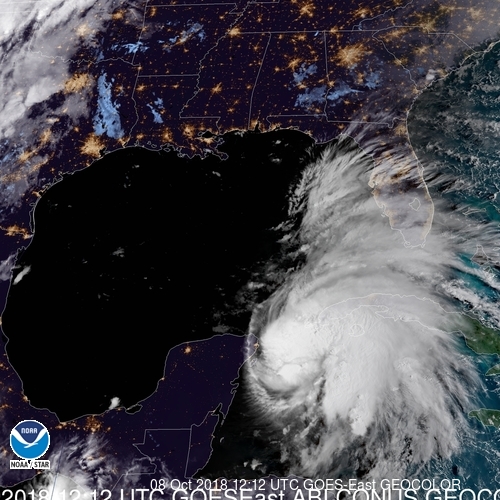
Satellite Image of Michael on the Morning of September 8, 2018 (Photo Courtesy of NOAA)
Currently Michael is maintaining maximum wind speeds of 75 mph (121 km/h) and expected to strengthen over the next 36 to 48 hours as it approaches the panhandle of Florida. Floridians are familiar with hurricanes especially after the past two years when Hurricane Matthew impacted the east coast of Florida in 2016, and Hurricane Irma carved its way up the center of Florida in 2017. However, the Gulf side of Florida is unique when it comes to hurricane impacts. Unlike the Atlantic side of Florida where after a few miles the continental shelf begins to drop off into deeper water, the Gulf side has a large continental shelf which provides shallow waters for miles offshore.
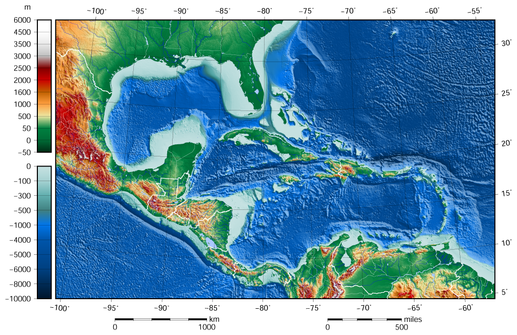
Bathymetry of the Gulf of Mexico, Caribbean and part of the Atlantic.
Due to the continental shelf extending so far outwards off the western side of Florida this causes not only contributes to shallow waters but typically warmer sea surface temperatures. It takes a lot less energy and time for a shallow pool to become warmer than a deeper one. The Gulf of Mexico can be seen as a small pool compared to the large Atlantic Ocean. Even during the winter months heat is maintained in this area and this is why when Hurricane Season starts up again in June each year we typically see activity first pop up in this area before the Atlantic. Same can be said for the month of October and November (end of hurricane season). The Atlantic is gradually becoming cooler in preparation for winter, however the Gulf tends to stay warmer and therefore continues to produce more hurricanes compared to the Atlantic.
However, these shallow warm waters are not the only concern in the Gulf of Mexico. Shallow water also means that storm surge is typically higher along this area compared to any other area in the United States. If it is one thing that residents along the Panhandle should be concerned about, it is the storm surge with Hurricane Michael. The more shallow a shoreline is, the greater chance of water displacement. Depending on the barometric pressure of a hurricane (lower barometric pressure equates to a stronger hurricane) it has the strength to lift up the ocean by several inches and this is what storm surge is. It’s much easier to lift a shallow body of water compared to deeper water and push it ashore. Additionally the shape of the Gulf of Mexico is unique and deadly. Once a hurricane enters or forms in the Gulf of Mexico there is nowhere for the storm to escape without impacting land. It’s like a bath tub. When a hurricane is approaching the land it is dragging the ocean water beneath with it as it comes ashore. The water has no choice but to follow, and because the Gulf is surrounded by land the water continues to come ashore and push far inland. So if you push yourself forward in a bathtub the water follows and is pushed forward causing the water to rise up at the front of the bathtub.
The Tampa Bay area could see some surge effects in the coming days because of the displacement of water in the Gulf, even though Michael will not be impacting this area directly. Therefore because of the structure and bathymetry of the Gulf of Mexico this is usually where we see historical storm surge heights and why meteorologists and the National Hurricane Center are concerned with Hurricane Michael.
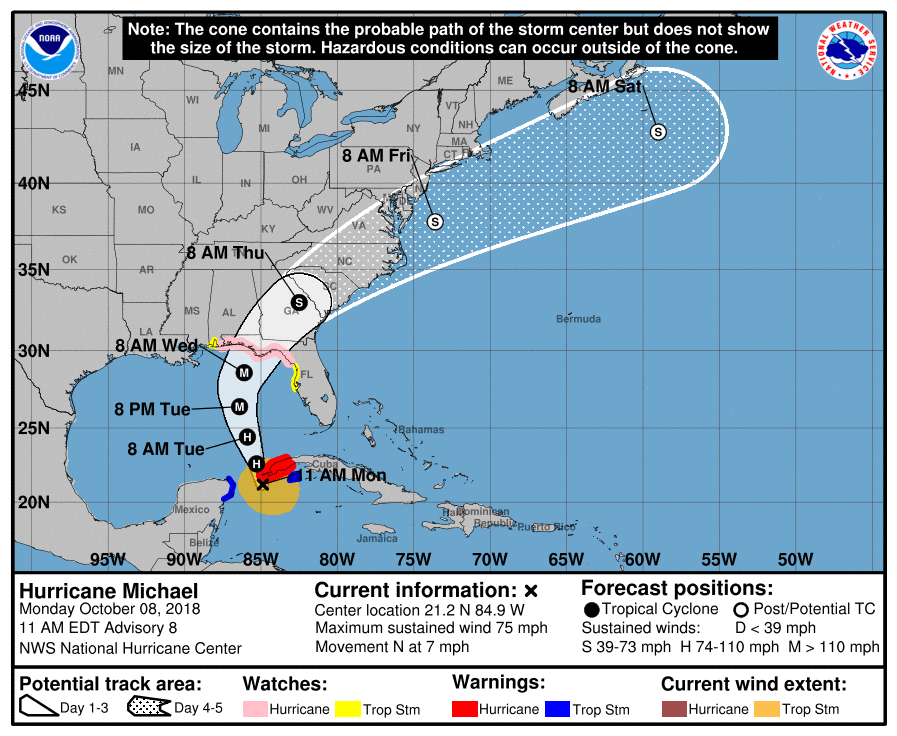
Projected Path of Hurricane Michael (Courtesy of the National Hurricane Center).
Late yesterday, October 7, 2018, Governor Rick Scott issued a State of Emergency for the Panhandle of Florida and preparations began to increase along the Gulf Coast. Unlike Hurricane Florence, residents currently only have about 36 to 48 hours to prepare for this storm. This is not a lot of time compared to the Carolinas which has about a week to prepare for Hurricane Florence. Emergency managers are advising residents to rush completions and evacuate as soon as possible if you live close to the shores, especially between the Florida cities of Crystal River and Apalachicola, as this is forecasted to be where the highest storm surge levels could be.
Michael may be a Category 1 hurricane right now but do not be surprised to see this hurricane intensify into a major Category 3 hurricane before landfall. Once again, the Gulf of Mexico is notorious for producing major hurricanes and strengthening these systems at the last minute. Hurricane Harvey from last year is a perfect example. It was only a Category 1 when it entered the Gulf of Mexico but in just a few short hours before landfall it underwent a rapid intensification and came out as a Category 4. The National Hurricane Center is advising the Panhandle of Florida to prepare for the potential of a low end Category 3. It may be possible (and we all hope) that Michael will only come ashore as a Category 2 or even a Category 1. However, no matter what category, the storm surge will be the deadly event with this system. Residents along the coastlines need to listen to their emergency managers and evacuate when told to do so.
Many are hoping that Michael will loose strength and potentially weaken before impacting the shoreline. We all hope that this is the case no matter what we forecast during a meteorological event, but we have to be realistic and prepare for the worst. Right now the Gulf of Mexico is maintaining those warm sea surface temperatures. Hurricanes need water temperature of 26.5°C (80°F) in order to grow and strengthen. Currently Michael is situated over waters that are between 28 and 30°C (82.4 – 86°F), prime for hurricane intensification. 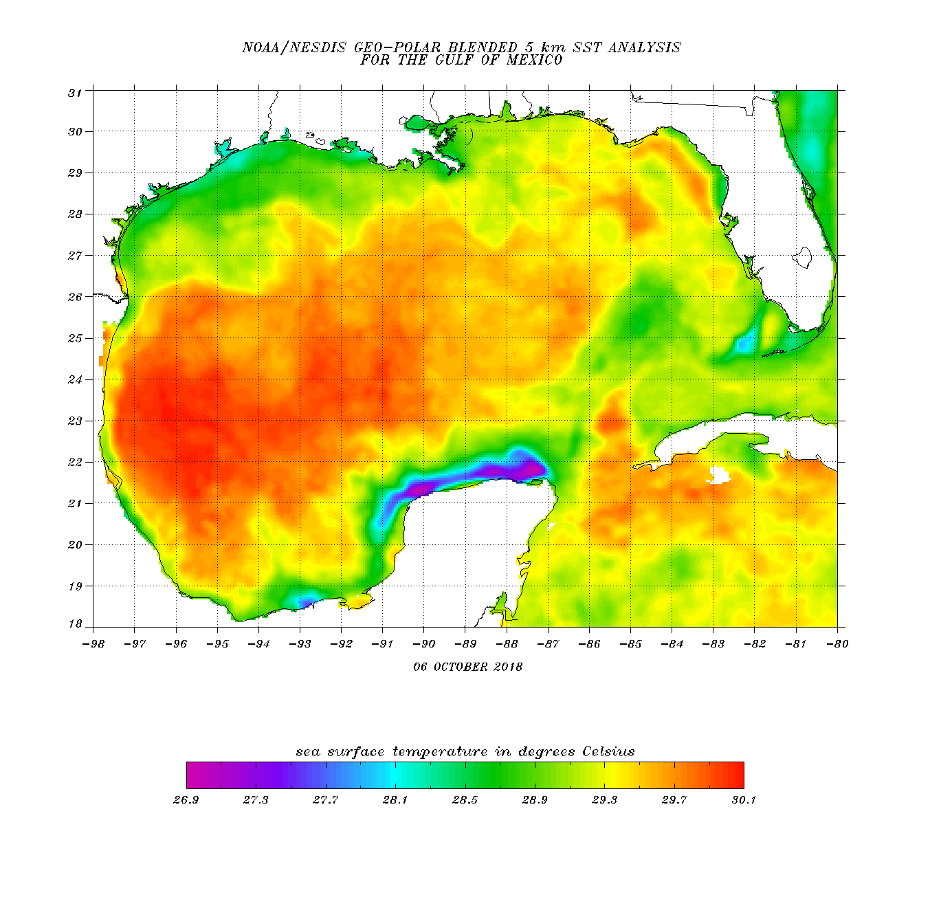
Sea Surface Temperatures in the Gulf of Mexico Taken on October 6, 2018 (Courtesy NOAA)
Another factor that we focus on is the upper level wind shear levels where Hurricane Michael is situated. While it may not be in a perfect environment for development the wind shear is not strong enough to break up Michael at the moment. The figure below shows the current wind shear levels for the Gulf of Mexico and the Atlantic. Michael is moving northward and will come into contact with some heavier wind shear as it makes its approach into the panhandle. While not ideal this will not be enough to completely tear apart Michael. However we could see a different type of problem that is rarely discussed – the shape of the hurricane.
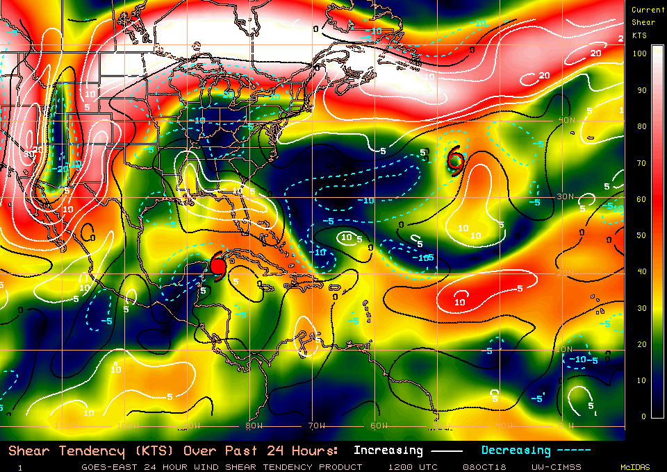
Current Wind Shear Values over the Past 24 Hours
Text book examples of hurricane usually depict them as round objects with an eye close to the center. The reality is that many hurricanes do not take this shape and it all has to do with the atmosphere surrounding the storm. If a hurricane enters into an area of high wind shear, or interacts with another weather system, like a trough or a midlatitude cyclone, it begins to be torn apart and alters its shape. What we will likely see as Michael travels northward is the displacement of clouds and rain around the center of Michael. The rain will shift to the east side of the storm delivering heavy rains and strong winds to portions of Florida over the next few days.
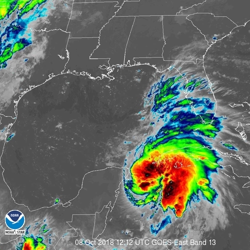
Imagery of Hurricane Michael on October 8, 2018 (Courtesy of NOAA)
Michael for the most part is maintaining most of its moisture towards its center core which is currently over western Cuba. However, you can see from the figure above that the shift in structure is changing further north. As Michael heads northward into this area of heavier wind shear the structure will change and we could see most of this rain and cloud cover shift and cover Florida which will bring heavy rains and even Tropical Storm force winds to parts of the state far from the Panhandle. The Florida Keys, for example, are far from the center of Michael and they have been seeing bands of heavy rain and even some surge since this morning. This already shows that the affects of Michael are not just close to the center of the storm, but far reaching.
Focusing on the types of impacts and what to expect across the southeast United States now. Many parts of Florida from the west to the east coast will receive some scattered rain from these outer bands over the next couple of days. The west coast of Florida and particularly the panhandle will see the heaviest amounts of rain, especially as Michael draws closer.
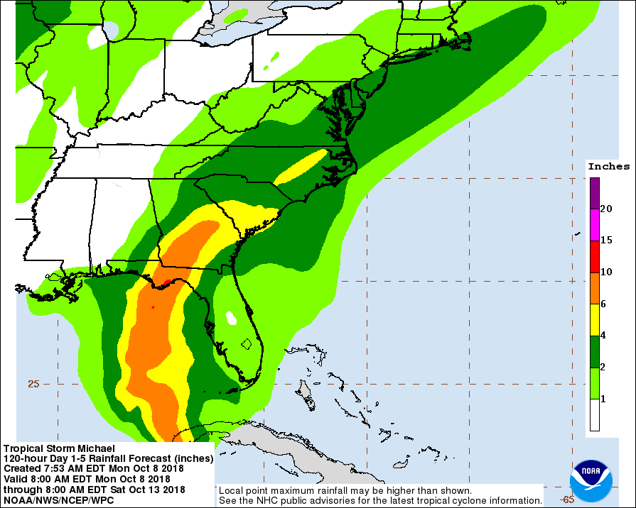
Forecasted rainfall amounts from Michael (Courtesy NOAA).
If there is any good news to this hurricane, it is that it will be picking up speed in the next few hours before making landfall. We are not expecting a Hurricane Florence or Hurricane Harvey event where the storm stalls over the coast for days dropping immense amounts of rain. Michael will be a “typical” hurricane that pushes through the area and moves ashore relatively fast. The faster a hurricane moves over the shore, the less rain, and the less duration of wind and storm surge. With forward speed picking up rain amounts are so far forecasted to reach 10 inches, but could be higher, especially around the Apalachicola area. This may be good news for Florida and Georgia, but the expected path of Michael takes it into the Carolinas where many areas are still recovering from the immense flooding and rainfall from Hurricane Florence. While many of the rivers are back to normal flood stage it won’t take much rain to bring them back to flood stage and Michael could potentially do this, especially in South Carolina. The Carolinas could receive 4 to 6 inches from this event by the end of the week which will hinder cleanup efforts in these areas and possibly trigger additional flooding. Residents in the Carolinas that are currently in areas vulnerable to additional flooding and still recovering should consider moving to higher ground. Fortunately, Michael will not be staying long in the Carolinas as it is expected to move back out into the Atlantic Ocean late Thursday into Friday.
Tropical Storm force winds are expected to impact most of the southeast United States over the next few days as Michael passes through. Even the east coast of Florida could potentially receive a few tropical storm force gusts as this system moves closer to shore.
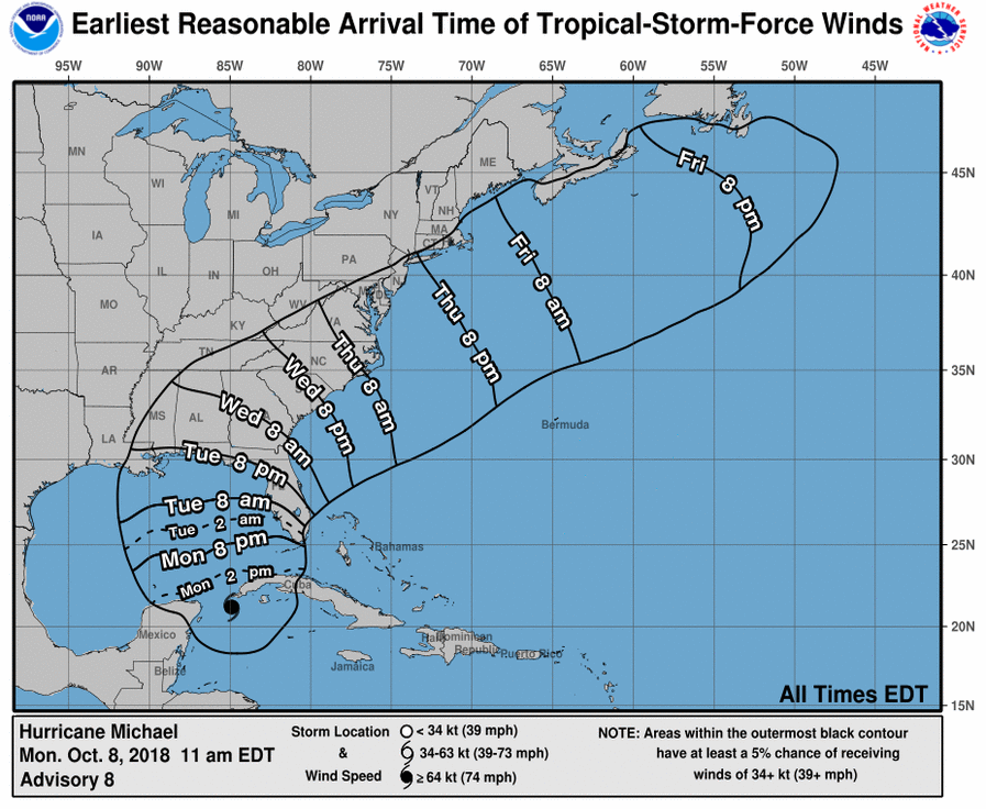
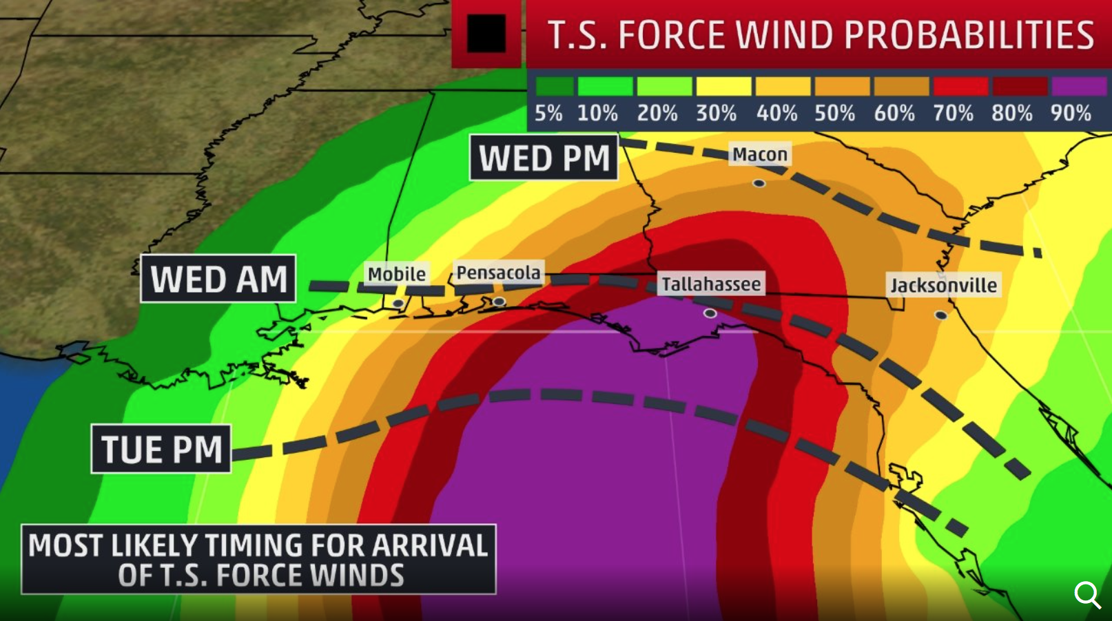
Left: Arrival Time of Tropical Storm Force Winds for Hurricane Michael (Courtesy NOAA). Right: Tropical Storm Force Wind Probabilities (Courtesy The Weather Channel).
Finally, the forecast that everyone residing in these areas should monitor closely, the storm surge. If there is one component to Hurricane Michael that we should keep our eyes on, it is this one. Storm surge watches are up from Pensacola down to the Tampa Bay area. Storm surge warnings are expected to be in place in the next several hours.
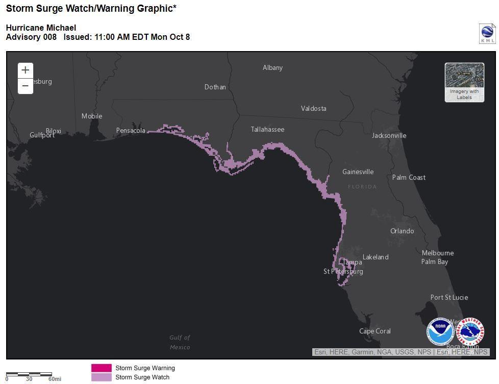
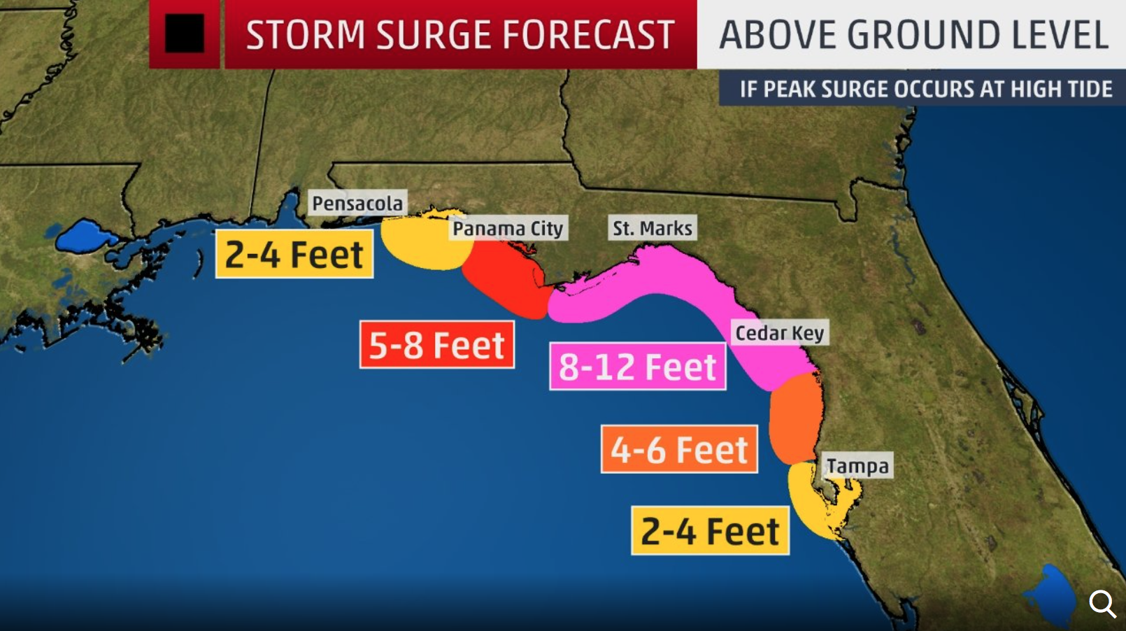
Left: Storm Surge Watches and Warnings (Courtesy NOAA). Right: Forecasted Storm Surge Height for portions of the Florida Panhandle and Western Florida (Courtesy The Weather Channel).
Areas along the northwestern bend of Florida could receive storm surge heights up to 12 feet, and this is not taking into consideration further inland. Rivers and streams connected to the Gulf will be backed up far inland creating flooding events far from the coast, a very similar scenario with what happened in Hurricane Florence in the Carolinas. This is the threat that many need to be aware of with Hurricane Michael as it moves closer to the Florida Panhandle. Residents along these coast lines need to take evacuation orders seriously and move further inland away from the coastlines.
The last time the Panhandle of Florida received a major hurricane was Hurricane Opal in 1995 when it came ashore in the Pensacola area as a Category 3 storm causing heavy and extensive damage to the Gulf Coast. This massive hurricane delivered 15 feet of storm surge to the Pensacola and Panhandle areas (Mayfield, 1995). Additional, Hurricane Hermine came ashore in 2016 along the Panhandle as a Category 1. This hurricane was the first hurricane to make landfall in the state of Florida since Hurricane Wilma in 2005 breaking the 10+ year long record for Florida being in a “hurricane-drought.” Due to the absence of hurricanes for so many years many residents were complacent and chose to not evacuate and prepare for Hermine. Heavy damage and extensive power outages took many residents by surprise. A maximum storm surge of 5.8 feet occurred at Cedar Key, Florida (Berg, 2016).
Panhandle residents should acknowledge and be aware that storm surge is a real threat with any hurricane that approaches their shoreline. Michael is no different. Time is running out for many to prepare and evacuate along the coastlines. Michael is only about 36 hours from making landfall and strengthening quickly. Hurricane Hunters are continuing to fly into Michael nonstop to update on any changes in strength. Residents need to listen to their emergency managers and evacuate when told to do so. Stock up on water, extra medication, non-perishable items, and make sure gas tanks and generators are full. After Hurricane Hermine many areas were without power for almost 2 weeks. Make sure you have enough supplies for your family and you to be comfortable for up to 2 weeks after the storm has passed.
The Weather Goddess website will be updated time permitting but up-to-date information can be found on the official Weather Goddess social media pages.
Facebook: Facebook.com/WeatherGoddess
Twitter: @Wx_Goddess
Instagram: @weather_goddess
References:
Berg, R. (2016). “National Hurricane Center Tropical Cyclone Report: Hurricane Hermine (AL092016).” National Hurricane Center. Accessed October 7, 2018.
Mayfield, M. (1995). “Preliminary Report: Hurricane Opal.” National Hurricane Center. Accessed October 8, 2018.
East Coast Preparing for the Arrival of Hurricane Florence
Updated September 10, 2018 @ 2:14 pm EST
We were all hoping Florence would stick to a typical climatological path northward but unfortunately this is turning into the worst case scenario. Hurricane Florence, currently a Category 4 hurricane, is taking aim at the east coast of the United States.

Hurricane Florence moving westward towards the East Coast of the United States (Photo:AFP/Getty Images)
A State of Emergency has been declared for the Carolinas as well as Virginia as Florence continues westward one the warm Atlantic waters. Businesses and universities across the areas are closed and evacuations are underway especially for those close to the shore. We have to come to terms right now that this is a potentially deadly situation and residents along the east coast need to start preparing for this storm immediately.
It has been a while since the state of North Carolina received a direct hit from a major hurricane. Hurricane Fran in 1996 was the last major hurricane to come ashore as a Category 3 at Cape Fear. One of the deadliest hurricanes to impact the state was Hurricane Floyd in 1999, which caused 35 fatalities and record breaking flooding (NOAA Hurricane Archives). The last hurricane to impact was Hurricane Irene in 2011 which came ashore along the Outer Banks as a Category 1. Therefore, it has been a long time since North Carolina in particular has received a direct hit from a hurricane (7 years). Some residents new to the state may not have even been through a true hurricane. This is a situation that needs to be taken seriously, because North Carolina could receive a record breaking hurricane late this week.
Hurricane Hunters have been flying into Hurricane Florence repeatedly to assess the strength and forward speed of the system. The last pass through revealed a low pressure center of 947mb, indicating a well organized and powerful storm. If this pressure continues to drop this indicates a strengthening in the storm.
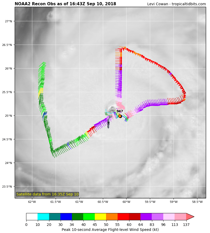
Track of the Hurricane Hunters Aircraft through Hurricane Florence on September 10, 2018
Unfortunately there is nothing stopping and hindering the strength of Hurricane Florence. Late last week many of us in the meteorological community were hoping Florence would meet up with a trough which would help move it northward and back out to sea away from the United States. Yet, Florence missed the connection and has been on a direct westward trend. Additionally the Bermuda High has been sitting just to the north of Florence acting as a barrier and keeping it to the south.
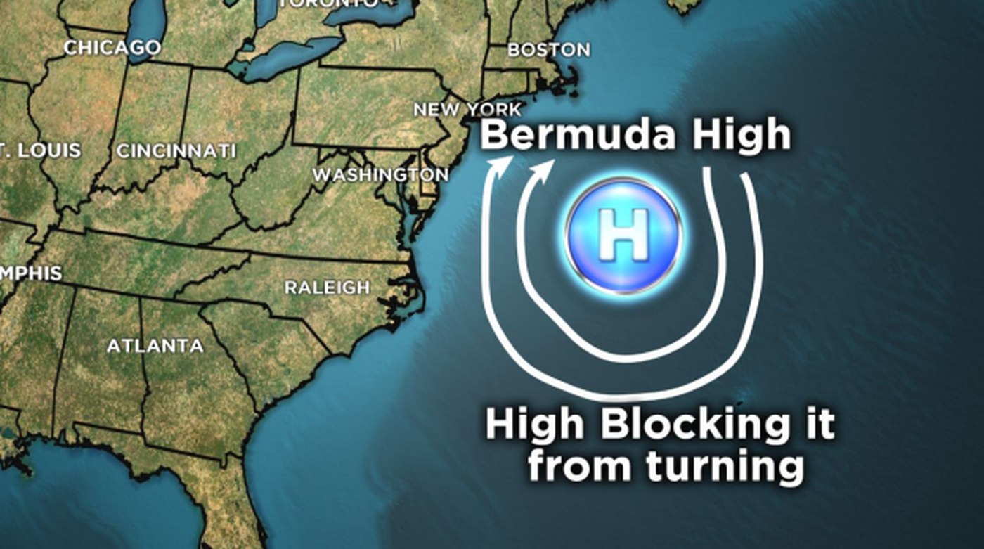
Approximate Location of the Bermuda High (Image from: WMC Action News 5)
A high pressure system (The Bermuda High) rotates in a clockwise direction and helps to steer hurricanes. This high pressure is partially causing Florence to take the westward direction. Because Florence is so close to the east coast Florence has no room to start turning northward while out at sea. If this turn does occur it will be while Florence is over land and this won’t take place until later this weekend. So, the Bermuda High is not working in our favor and steering Florence away. To make matters worse the sea surface temperatures and wind shear levels are perfect for hurricane formation and intensification.
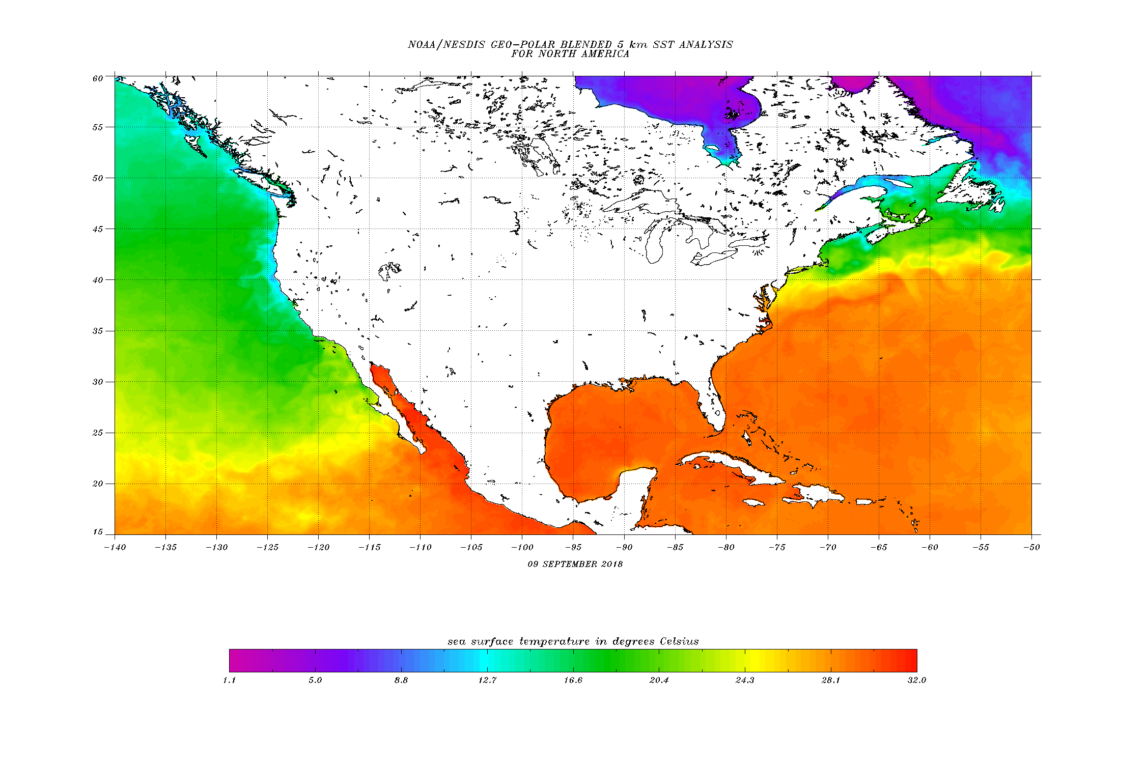
Current Sea Surface Temperatures taken September 9, 2018 (Photo: NOAA)
A hurricane needs water temperatures of 26.5°C (80°F) in order to form and evolve. We are beyond this threshold off the coast of the southeast United States. Water temperatures are averaging close to 30°C (86°F) in these areas which is just helping Florence to strengthen. Looking at wind shear values we can also see the atmosphere is “cheering” for Florence:
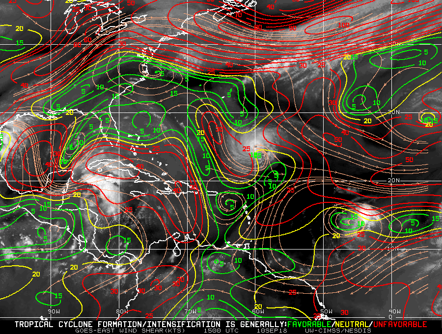
Wind Shear Levels in the North Atlantic Basin for September 10, 2018 (Photo: CIMSS)
Florence is entering into a favorable area with minimal wind shear (green color) which will help the hurricane keep its circular structure and remain a strong major hurricane. There is nothing to help weaken Florence and this is why the East Coast especially the Carolinas and Virginia need to start preparing for the worst. Florence is coming and even if Florence does turn slightly northward the storm is already so close to the United States, it does not have enough room or time to turn and avoid impacting land.

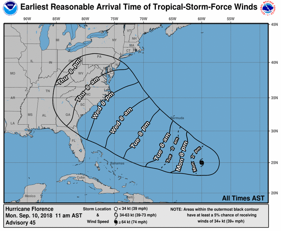
Left: Cone of Uncertainty and Forecasted Strength of Hurricane Florence this Week. Right: Arrival Time of Tropical Storm Force Winds for this Week. (Photo: NOAA)
Today, Tuesday and Wednesday will be the final days to prepare for this storm as it approaches and areas will even start to feel the effects of Florence as early as Wednesday night with the arrival of Tropical Storm force winds. North Florida, Maryland, and New Jersey may not receive a direct hit from this system but the size and extent of the winds will be felt along these areas. In addition rip currents will be a concern along the eastern seaboard. Use extreme caution when swimming and boating over this next week for areas far from Florence.
Residents and visitors to the Carolinas should avoid the shore and evacuate further inland or if possible to the north or south of the storm. Florence is currently and likely to impact land as a major hurricane (Category 3 or higher) and this will deliver intense and damaging winds that could potentially be upwards of 150 mph (241 km/h). High storm surge will also be a threat and potentially the most deadly scenario with this storm. Storm surge watches and warnings have not been issued for areas along the eastern seaboard yet but they will be issued very soon by the National Hurricane Center. Do not be surprised to see forecasted storm surge values around 10 feet or higher. This is a major hurricane after all and as it comes ashore it has the power to displace an immense amount of water and push it far inland. There will also be flooding concerns inland as streams and rivers backup and overflow far inland away from the coast. This is not just a coastal event it is also an inland event. Unfortunately, models are showing a decrease in forward speed once Florence makes landfall and can easily stall over the region for a few days after it comes ashore. While it may weaken rapidly this is not the time to go outside and resume your daily lives. Just because the wind speeds of a storm have decreased thus lowering the categorization on the Saffir-Simpson Hurricane Wind Scale does not mean the storm in general is weakening and gone. The Saffir-Simpson Hurricane Scale does not take into account rain and forward speed of a system and this is what will make Florence deadly once it stalls over land.
Recall Hurricane Harvey from the 2017 Hurricane Season when it impacted and came ashore as a major Category 4 hurricane along the Texas Gulf Coast. Harvey then stalled inland dumping historical amounts of rain causing neighborhoods to flood, especially in the Houston metropolitan area. Florence can very well be a similar repeat to Hurricane Harvey with the heavy rains and inland flooding. Florence is not going to be a quick storm, it is going to be a long storm that lingers around the Carolinas, Virginia, and even up towards West Virginia. If you evacuate further inland away from the coastlines you may be spared from the storm surge and high winds but you will likely have to face the flooding effects from Florence. The best course of action is to travel far from the storm. If you are in the Carolinas consider heading south towards southern Georgia and Florida (call it a mini vacation and go to Disney World). Or consider going north into Maryland and beyond. This will allow your family to be safe and to be far from all the impacts of Florence.
The National Hurricane Center has been issuing advisories and will continue to do so over the next few days as Florence draws closer.
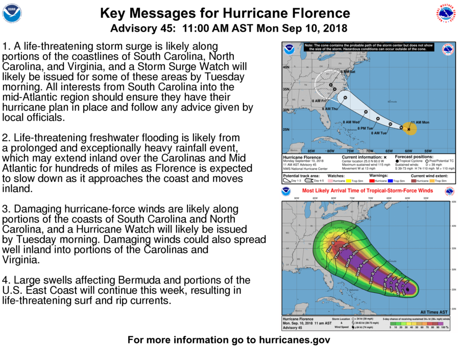
Key Messages from The National Hurricane Center for Hurricane Florence on September 10, 2018 (Photo: NHC)
The National Hurricane Center is encouraging everyone to have a hurricane plan in place and be ready for this storm. This is not a hurricane you want to ride out. Areas close to the powerful center of Florence could be cut off for days after the storm. Along the Outer Banks of North Carolina for example, emergency crews may not be able to reach these places immediately after the storm. Roadways and bridges could be washed out and immense structure damage could block roadways. I encourage everyone along the coastline of the Carolinas, especially North Carolina to evacuate further inland.
Most meteorological models are in agreement that Hurricane Florence will be coming ashore as a Category 4 or possibly a Category 3 storm.
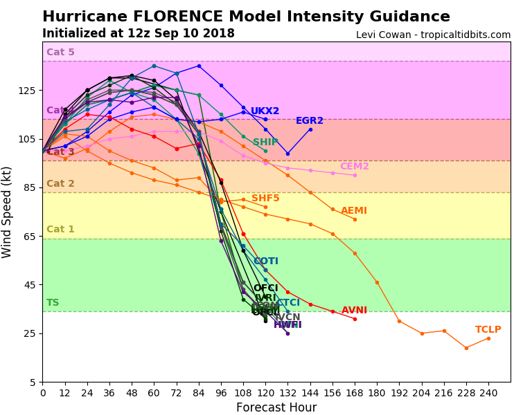
Forecasted Strength of Hurricane Florence by Hour
Once more there is nothing to help weaken or even to help turn this system away from shore. Meteorologists and the National Hurricane Center are becoming more certain by the hour that the east coast will receive a direct hit.
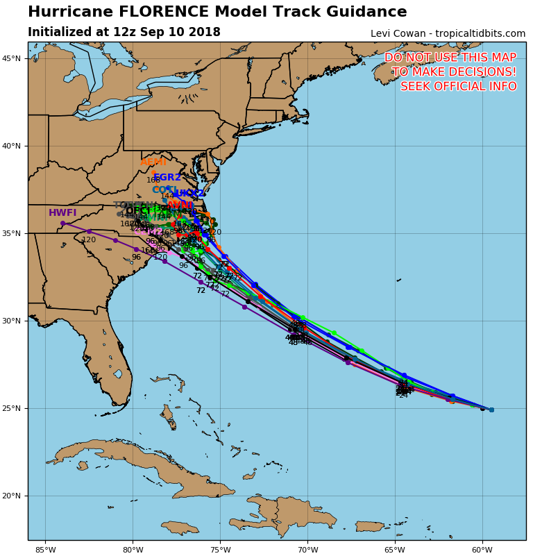
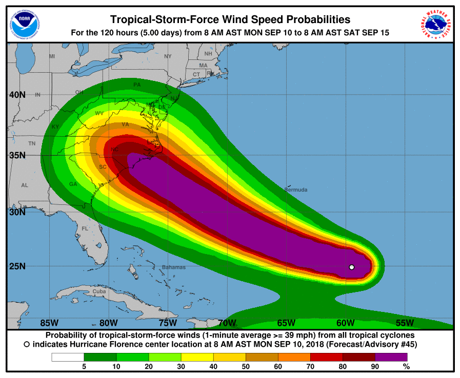
Left: Spaghetti Plot Showing the Different Meteorological Models and the Projected Path of Hurricane Florence. Right: Tropical Storm Wind Speed Probabilities for Hurricane Florence (Photos: NOAA)
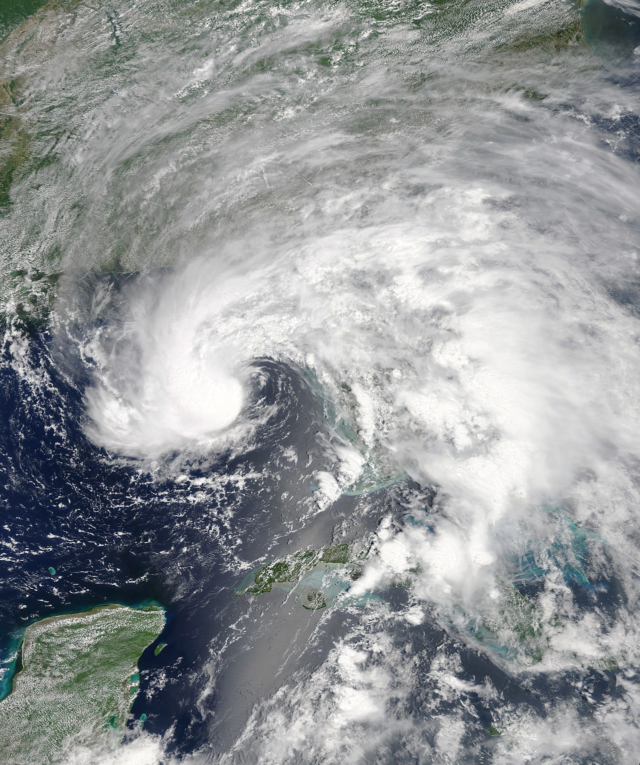
Most models are showing Florence coming ashore in the state of North Carolina sometime on the evening of Thursday (September 13) or overnight into Friday. North Carolina is nearing a 100% chance of experiencing Tropical Storm force winds but even areas as far away as Florida and New Jersey have a small chance of experiencing these strong tropical storm force winds. This all depends on the size of Florence as she approaches the coast over the next few days. Currently Florence is a large hurricane and maintaining a perfect “hurricane formation” with a well defined eye.
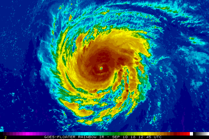
Current Animation Image of Hurricane Florence Taken September 10, 2018 (Photo: NASA).
We have gone over the meteorological process and forecast for Florence but now is the time for residents to prepare. There are only 2 – 2.5 days left to prepare which may not seem like a lot of time but on the grand scheme of meteorology and forecasting this is an incredible amount of time to help inform the public and get people to safety. If you have not done so you need to start your hurricane plans now.
Stock up on water and non-perishable items. These are quickly flying off the shelves in the Carolinas but stores are continuing to receive daily and hourly shipments. Also make sure you fill up your gas tank especially if you are evacuating. You do not want to run out of gas on the highway. Roads will be congested with traffic over the next few days as people are trying to get out of the area. Be patient and calm. Everyone wants to get out of Florence’s way, rushing can lead to accidents which will cause even further delays.
Make sure you have enough medication for an additional week or a month if you can. Clear your yards and porch areas of anything that could be picked up by the powerful winds and secure them in place.
If you have animals consider evacuating to an animal friendly shelter or bring them to your local vet and boarding facility. Many of these will gladly look after your pet free of charge. Do not leave your pet alone during this event. They are members of your family and are just as frightened and nervous as you.
Children should have some activities to keep them entertained and keep their mind off of the storm especially when staying at an evacuation center. Make sure to bring clean clothes for a week if you can. Also bring anything of value: a wedding dress, photos, sentimental items.
Make sure to pack a house deed, insurance bill, or an electric bill. These will also be useful in case you need to present it to emergency personnel to prove you live at your place and to be able to return home after the storm.
First make sure you and your family are prepared but make sure to check on your neighbors and the elderly. Many may not have a plan in place and may not know what to do in this situation. Be that helping hand and help your neighbors and even consider getting them to an evacuation shelter. This is the time that we need to be there for each other and help one another survive and be protected from this storm.
It’s September 10 which by hurricane statistics means it is the peak of Hurricane Season. It certainly looks and feels that way. Florence is on her way towards the Carolinas and that is our greatest concern right now. However, right behind Florence with have Helene and Isaac.
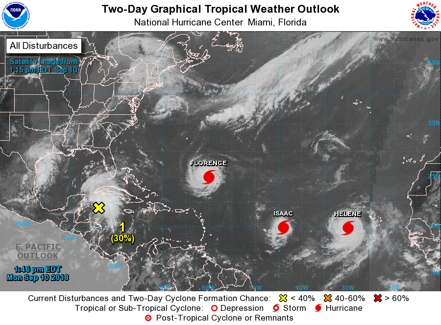
Tropical Weather Outlook for September 10, 2018 (Photo: NOAA)
Helene is not a problem and is expected to move northward but we should pay some attention to Isaac by the end of this week. We also have another area entering into the Gulf of Mexico which could become a problem over the next few days.
Countries bordering the Atlantic Ocean are surrounded on all sides it seems but this is what we expect during September, the peak of Hurricane Season.
Up-to-date information regarding Hurricane Florence can be found on the official Weather Goddess social media pages. Blogs will be updated time permitting.
Gordon Takes Aim While Strengthening
Updated September 4, 2018 @ 2:13 pm EST
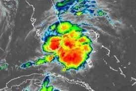
The seventh named storm of the 2018 Atlantic Hurricane Season has it’s sight on the Gulf Coast. September is here and this means an increase in hurricane activity for the Atlantic Basin. The National Hurricane Center has been keeping an eye on this system since late last week when it was in the Caribbean. Although only a tropical wave at the time “Gordon” brought heavy rains to parts of the Caribbean Islands as it moved generally northwest towards the southern tip of Florida where Hurricane Hunters were deployed to investigate the system. The name Gordon was then given to the tropical wave when the flight crew determined Tropical Storm force winds.
(Forecasted track of the Tropical Wave on August 30, 2018 – Courtesy National Hurricane Center)
Flash flood warnings and tropical storm warning were put in place for south Florida as well as along the Gulf Coast states from Louisiana over to the Florida Panhandle. While Florida is drying out from the heavy rains Gordon has moved off and entered into the warm “bath waters” of the Gulf of Mexico, known to be an intense fuel source for tropical systems. The Gulf is prime for storm intensification and this is what we are currently seeing with Gordon.
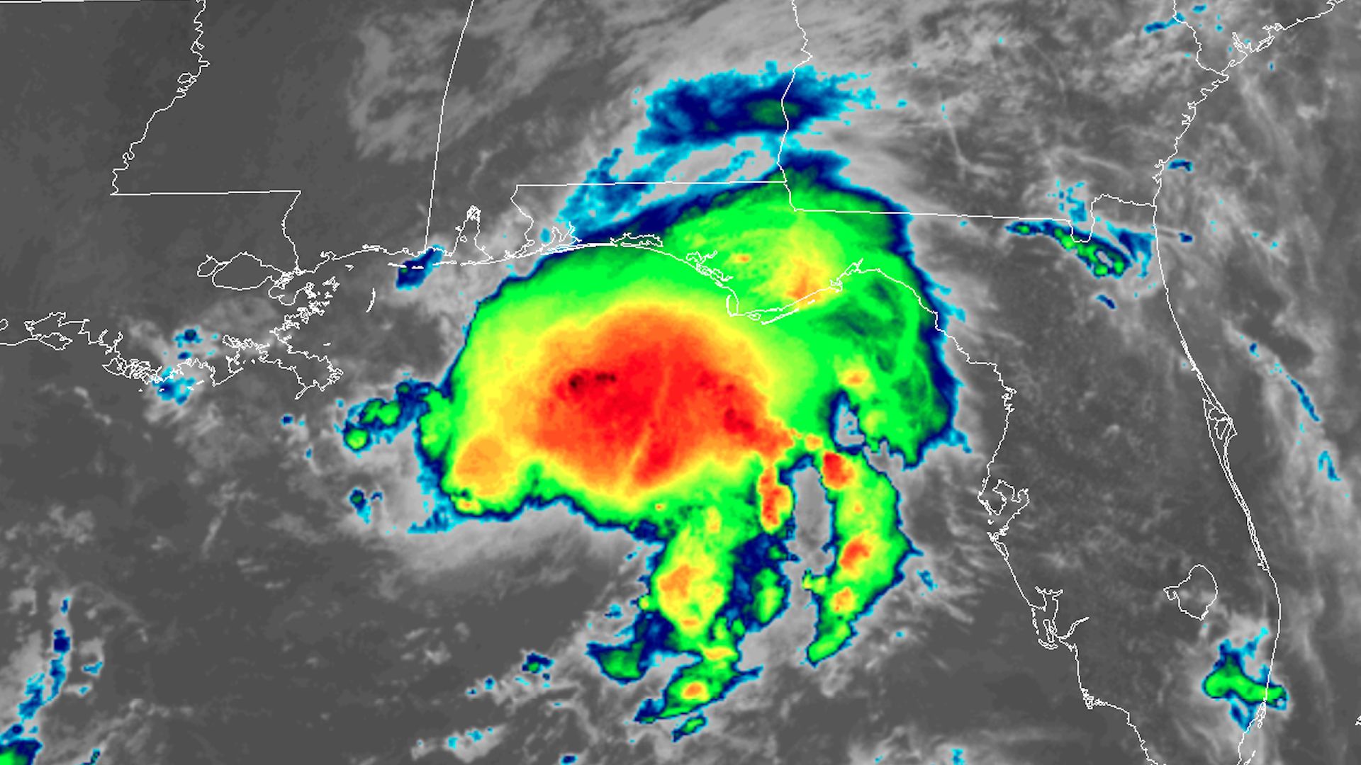
(Left: Tropical Storm Gordon on September 3, 2018. Right: Tropical Storm Gordon on September 4, 2018)
Yesterday while crossing South Florida Gordon was still relatively disorganized with the core of the storm (bright reds and oranges) still scattered about as thunderstorms continued to build around the center of low pressure. However, today the system is more organized as Gordon spins in the Gulf. The thunderstorms are compacted close to the center of circulation and continuing to grow and expand around the center. This is showing Gordon as an intensifying storm. Additionally the wind shear values are almost non-existent in the Gulf of Mexico:
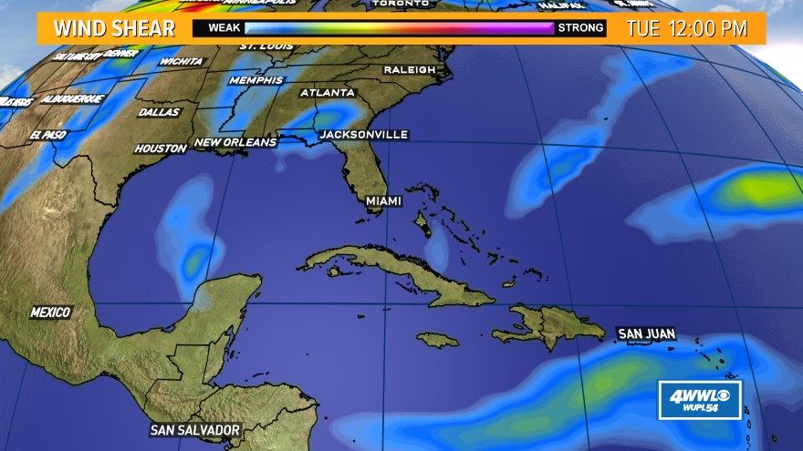
(Current wind shear intensities for Tuesday September 4, 2018)
Gordon has no obstacles to overcome and strengthen. Wind shear values are very weak in the area Gordon is located at, which is a good sign for strengthening and this is what has meteorologists and emergency responders on high alert. As of the 1:00 PM CDT intermediate advisory Gordon is maintaining winds of 65 mph (104.6 km/h). Once winds increase to 74 mph (119 km/h) Gordon will be designated as a Category 1 hurricane.
Without a doubt, Gordon is not going to dissipate or escape from the Gulf of Mexico without impacting land. Gordon is taking aim at the Gulf Coast and Hurricane Warnings have been issued for the coastlines of Mississippi, Alabama, and extreme eastern Louisiana.
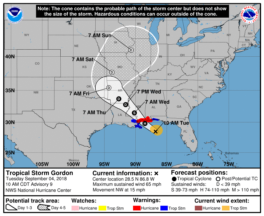
(Forecasted track and intensity of Tropical Storm Gordon – Courtesy of the National Hurricane Center)
Alabama, Louisiana and Mississippi are all under a state of emergency and are urging residents to prepare now.
Brian E. Hastings, the director of the Alabama Emergency Management Agency. “If you live in the coastal counties, especially in surge- and flood-prone areas, it is imperative that you get to a safe place by early afternoon and stay there through Wednesday morning.” (New York Times)
Numerous schools have closed their doors along the Gulf coast Tuesday morning. Many of these could remain closed tomorrow as well.
In Biloxi, Mississippi evacuations are currently underway for areas close to the shores including harbors and marinas.
We are not expecting a Hurricane Harvey situation from 2017. The difference is that Harvey was moving very slowly before it impacted the Texas coastline and this allowed it to undergo rapid intensification and strengthen to a major Category 4 hurricane before making landfall near Rockport, Texas. Gordon is moving fairly fast at 15 mph (24 km/h) and will not be able to undergo a rapid intensification in time before it collides with the land and weakens. Gordon will have only spent about a day in the Gulf compared to Harvey which had about 3 days over the open waters of the Gulf of Mexico to strengthen.
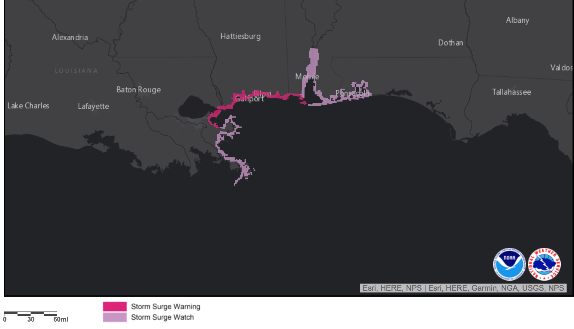
Gordon will likely impact the Gulf Coast late tonight (September 4, 2018) and overnight into Wednesday as a minimal Category 1 hurricane or a high end Tropical Storm. Storm surge watches and warnings are up for the Gulf Coast:
The main concern with this system will be the heavy rains and potential for severe flooding, especially along the coastlines and once Gordon makes its way onshore.
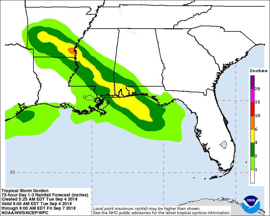
Most areas could experience rain amounts close to 4-5 inches with some areas possibly receiving close to 6-7 inches, which will likely take place far inland around Arkansas and Missouri. These heavy rains will take place as Gordon weakens and could very well undergo extratropical transition. This will allow the storm to grow in size to be about ten times larger than its tropical from allowing the system to hold more rain and distribute it across a greater area.
Now is the time to prepare. These last few hours will be crucial to residents along the Gulf Coast. Emergency managers are encouraging people to stay away from the shorelines and evacuate further inland. Make sure that you have your emergency kits ready and stocked. Gordon is approaching and strengthening fast, take this storm seriously and be ready.
Tiny Beryl Becomes the First Hurricane of the 2018 Atlantic Hurricane Season
Updated July 6, 2018 @ 12:44 pm EST
We have our first hurricane of the 2018 Atlantic Hurricanes Season and it is a very tiny storm.
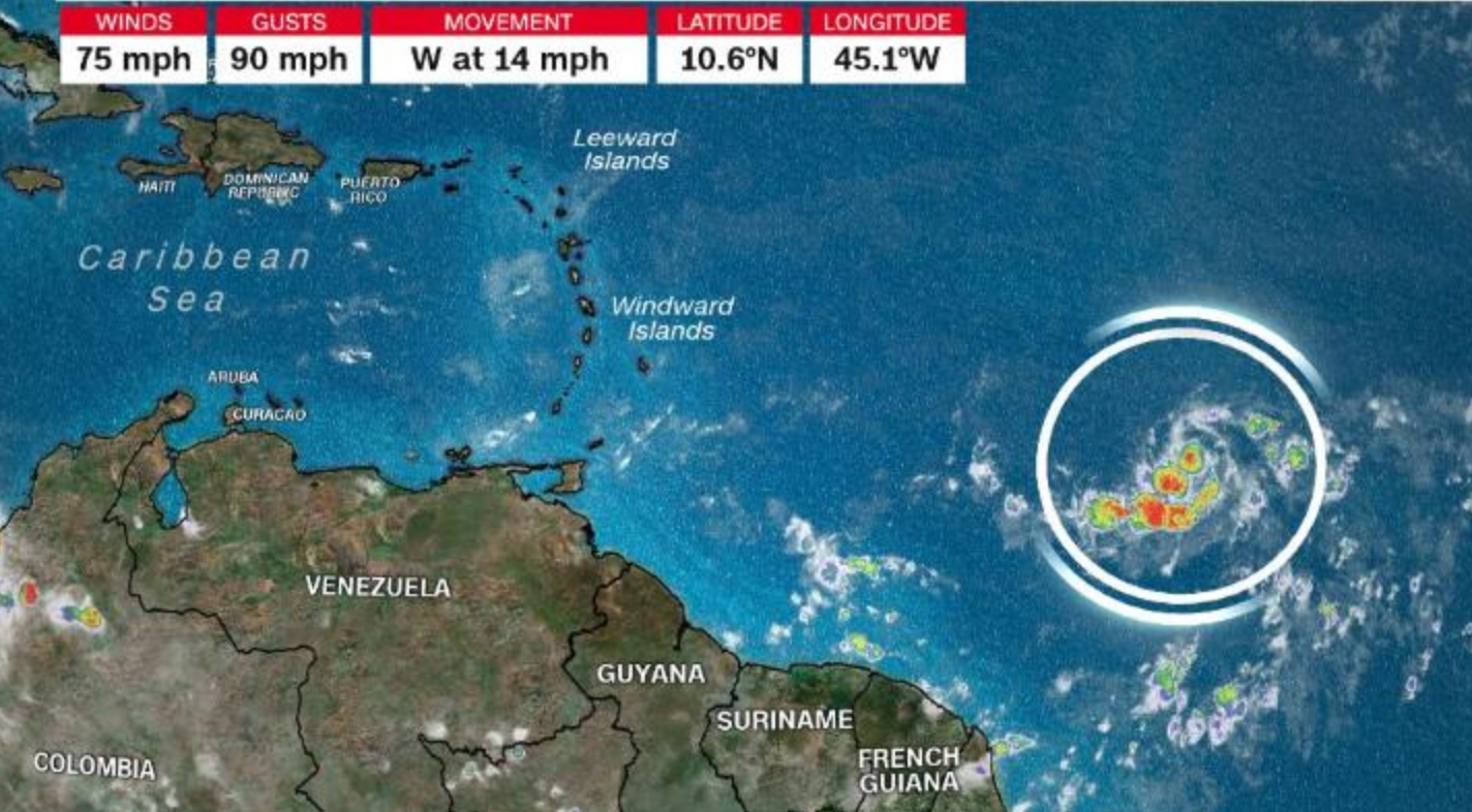
This tiny cluster of thunderstorms is Hurricane Beryl as it travels on a primarily westward direction at about 15 mph. Despite its size it has managed to intensify and continues to do so. As of the 11am advisory from the National Hurricane Center, Beryl has strengthened its winds to 80 mph still maintaining a solid Category 1 strength on the Saffir-Simpson Hurricane Wind Scale. However, Beryl is heading into trouble which could help spare the Windward and Leeward Islands in the Caribbean.
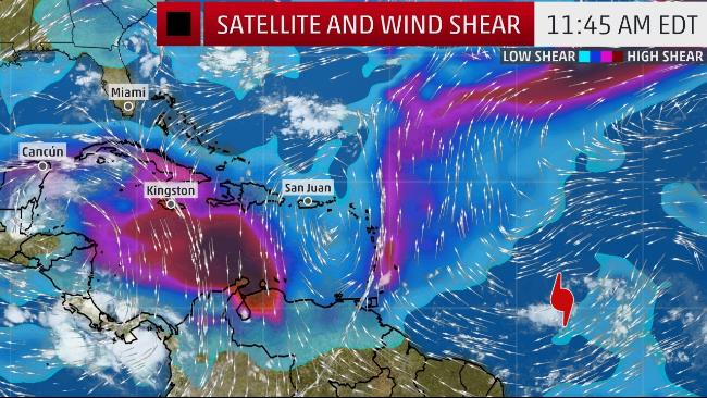
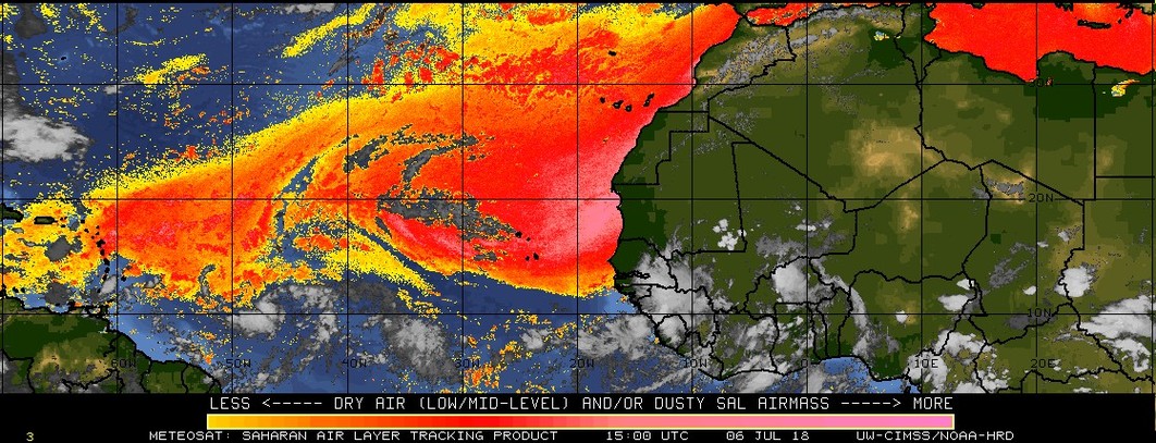
Top Image: Upper level wind shear values and intensities. Bottom Image: Saharan dust levels in the atmosphere
Relating to the top image, a patch of intense wind shear lies just in front of Beryl and is blocking the storm from the Caribbean Islands. This patch will help to tear the tiny storm apart and potentially weaken it to a low end Category 1 or a Tropical Storm before it impacts the islands late this weekend. Additionally, if Beryl holds together and exits into the Caribbean Sea it is still not out of trouble. There is a larger plume of wind shear to the south of the Dominican. If this area continues to harbor intense winds this will likely be the end of Beryl. Hurricane Beryl also has to worry about the moisture in the air to keep itself together. The second image above shows how much Saharan dust is in the atmosphere over the Atlantic Basin. Over the past few months we have seen an increase in Saharan dust traveling over the Atlantic and this hinders hurricane formation. Beryl is tracing the southwest corner of this large swath of dry air and avoiding it for the most part, but to reach the Caribbean Beryl will have to interact with some of this dry air which could help to weaken the system. This dry air prevents Beryl from evaporating more ocean water and condensing it into clouds, in one way the air is chocking the storm to death.
Due to the small size of Beryl this storm is very fragile and any change in the atmosphere surrounding this storm will significantly affect the evolution of the hurricane. Unlike a large hurricane which can create its own “micro” climate and affect other weather systems near the storm, a smaller hurricane is at the mercy of other surrounding elements and will weaken faster than a larger hurricane. If Beryl were a large system it would likely survive the wind shear and dry air and potentially last for a longer period of time. However Beryl is tiny. Likely one for the record books.
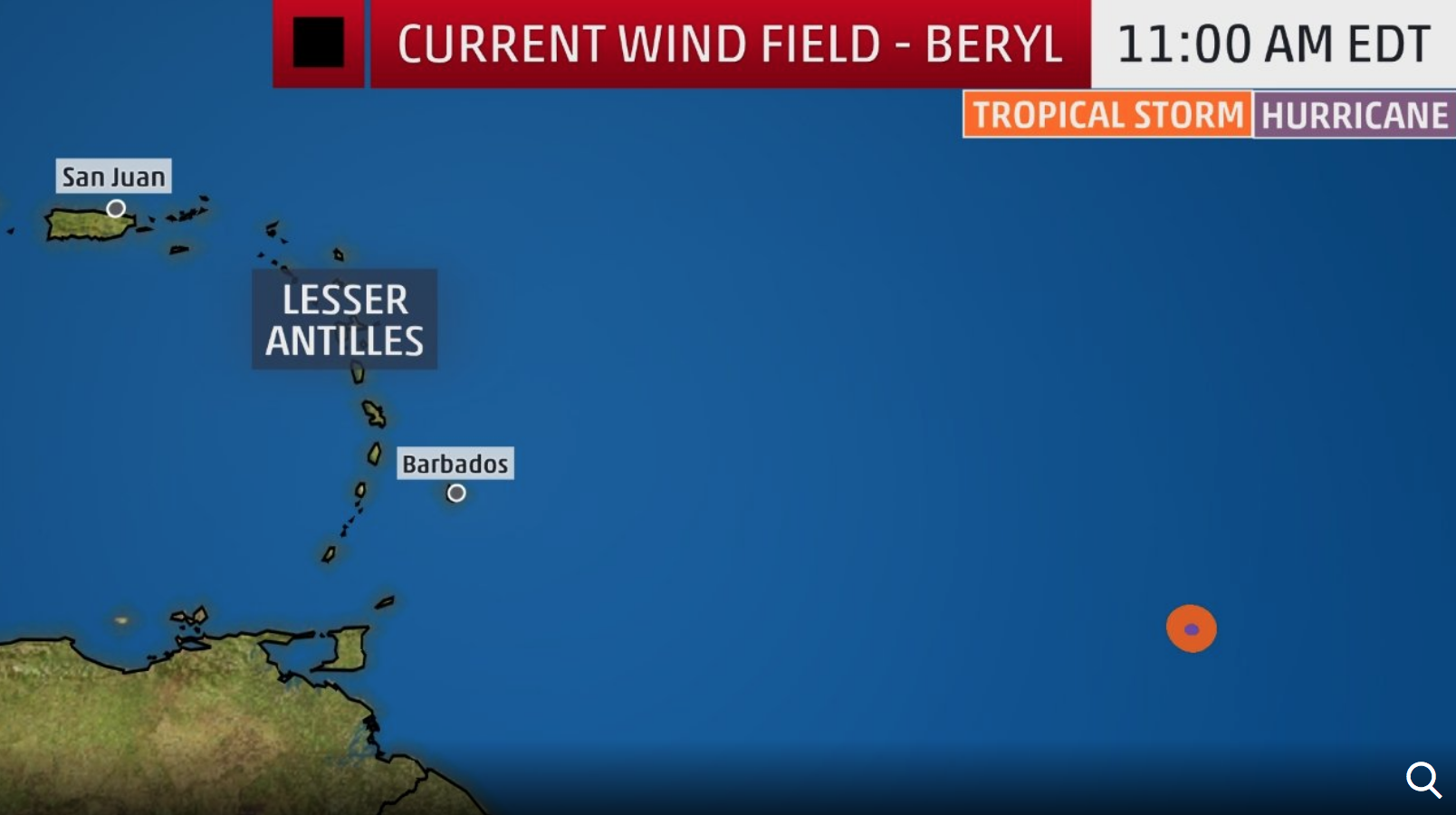
Tropical Storm (orange) and Hurricane Force (Purple) Estimated Wind Areas.
The National Hurricane Center and forecasters are estimating that the eye of Beryl is only 5 miles wide and the wind field is about 60 miles in diameter. To put that in perspective above, Beryl is about the size of some of the islands in the Lesser Antilles (only taking into consideration the wind). Beryl could likely keep its hurricane strength as it approached the eastern Caribbean Islands late Sunday night but with the interaction of the wind shear Beryl could weaken fast to a Tropical Storm as it pushed through the Lesser Antilles and into the Caribbean Sea.
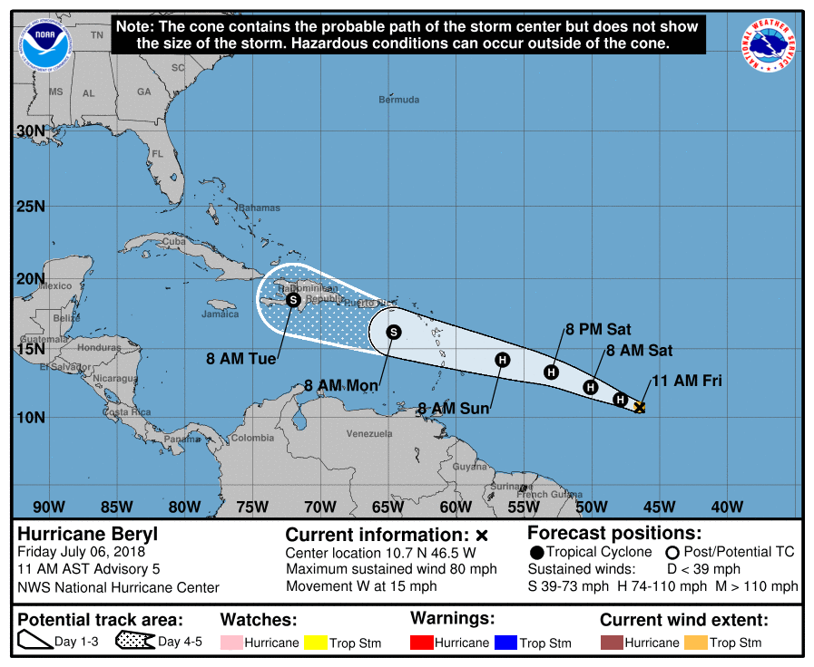
Track Forecast Provided by the National Hurricane Center
If the larger plume continues to be in the south Dominican, it can help destroy the remains of Beryl once it enters into the Caribbean Sea. However, there is a chance that Beryl can maintain its tropical storm or tropical depression status and continue its journey across the Caribbean Islands, and this is where is could get interesting. The more time Beryl stays over land, the more likely it will dissipate, especially if it continues to be a smaller storm. However, if it can avoid the island of Cuba and stay over the open water it could maintain Tropical Storm strength. While unlikely, it is possible. Hurricane Harvey last year traveled in a similar direction to Beryl and became a remnant low in the south Caribbean sea until the remains exited into the Gulf of Mexico and rapidly intensified to be a Category 4 hurricane before coming ashore near Rockport, Texas. Beryl is different though and we don’t want to think about another Harvey repeat. However, the possibility always remains that Beryl can continue to survive and maintain its tropical status. However, because of its small and fragile state Beryl is not going to make a historical comeback like Harvey.
Tropical Storm Watches and Warnings will likely be issued as early as tonight for the Lesser Antilles. Regardless of intensity the islands will receive gusty winds and heavy rainfall for Sunday and Monday with the Dominican expected to see these same affects for Monday and Tuesday.
June 1st! Opening of the Atlantic Hurricane Season!
Updated June 1, 2018 @ 1:26 am EST
June 1st is here and it is known as the official opening date to the Atlantic Hurricane Season. Already we are off to an early start with the first storm of the season already formed in late May making this the 4th consecutive year for cyclones forming before the official start of the season.
Subtropical Cyclone Alberto formed late last week near the Yucatan Peninsula and slowly traveled northward into the Gulf of Mexico before making landfall along the panhandle of Florida on Memorial Day (May 28).
Left: Subtropical Storm Alberto nearing landfall in Florida on May 28, 2018. Right: Path and strength of Subtropical Storm Alberto (Courtesy of NOAA).
Although not designated as a “tropical” system Alberto brought heavy rains to Florida, Alabama, Mississippi, the Carolinas, and Georgia for several days and traveled far inland. Alberto maintained Tropical Depression status and became one of only eleven cyclones to reach Lake Huron in recorded history (Wenckstern, 2018).
With the formation of Alberto in the month of May many may be wondering if this is a sign of things to come. Alberto was lucky to evolve into a cyclone and it all had to do with its location. During the month of May the majority of the North Atlantic sea surface temperatures are below the threshold for hurricane formation (80°F/ 26.5°C). However, the Caribbean and the Gulf of Mexico generally stay warmer than the open ocean due to the shallow depth and surrounding landmasses.
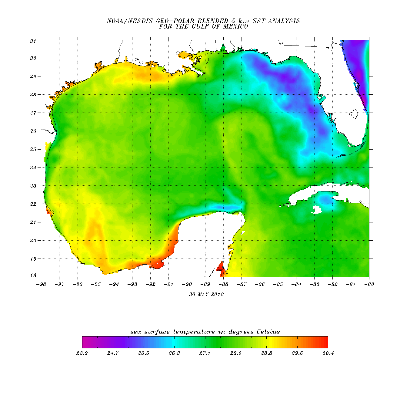
Current sea surface temperatures for the Gulf of Mexico and western Caribbean for May 30, 2018 (Courtesy NOAA).
Currently the Gulf of Mexico is maintaining prime temperatures for cyclone development and this is what Alberto utilized last week as it impacted the Gulf Coast. Regardless of the warm sea surface temperatures in the Gulf of Mexico there is generally a high amount of wind shear still present in the atmosphere during the month of May and June. This wind shear is left over from the winter months and helps to tear forming thunderstorms apart and prevent them from growing and expanding to form a low pressure center (the beginning stages of tropical storm formation).
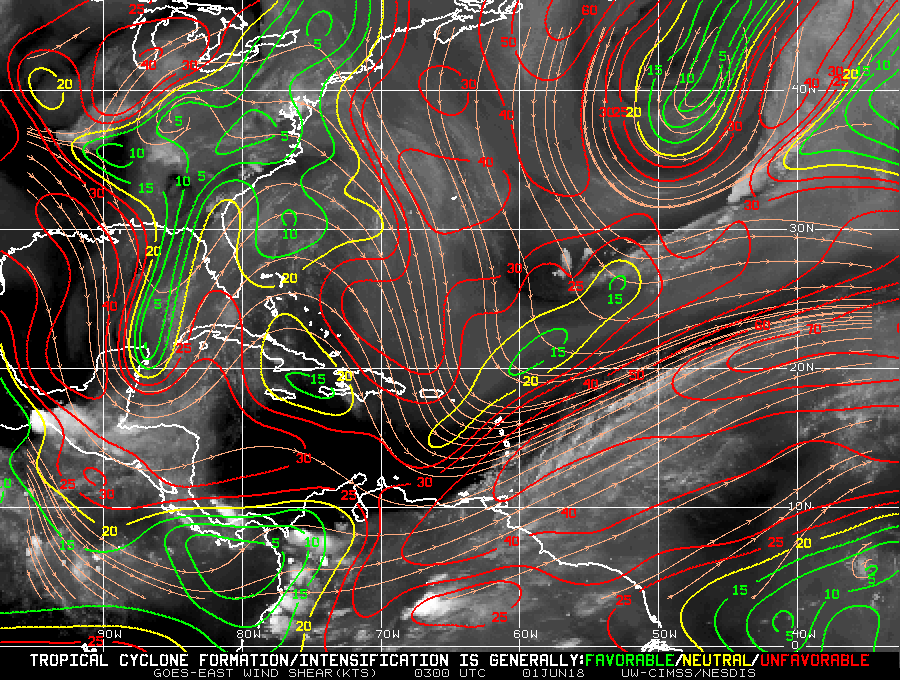
Wind shear map for North Atlantic Basin for June 1, 2018. Green depicts areas favorable for tropical cyclone development (less wind shear); red is unfavorable for formation (high wind shear).
The past few weeks have shown unfavorable conditions in the Gulf of Mexico, particularly to the west. As Alberto moved into this area the west side of the storm was sheared and portrayed very little cloud cover. However the east side of the Gulf of Mexico and over the state of Florida showed little wind shear and the majority of the cloud cover from Alberto was secluded to the east side of the center of low pressure which gave the storm an “uneven shape” and helped to designate it as a subtropical storm.
Currently from the wind shear map above there is very little chance for any additional storms to form in the coming days. Wind shear is taking up most of the Gulf, Caribbean, and open Atlantic Ocean preventing any formation. This is so far a good sign for the beginning of June. Usually these strong wind shear values do not die down until July and August.
Moving onto what to expect for the 2018 Hurricane Season. Earlier in the year meteorological agencies released their forecasts on what to expect this year, with many calling for another active season similar to 2017.
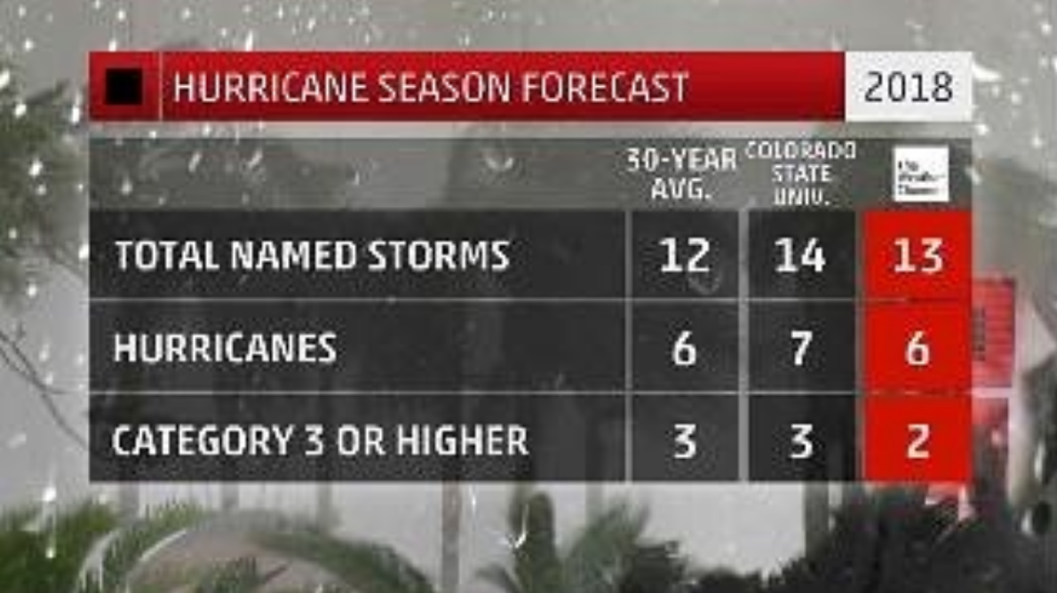
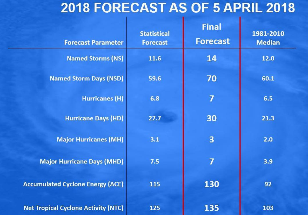
April 2018 hurricane prediction numbers for the 2018 Atlantic Hurricane Season provided by Colorado State and The Weather Channel.
The Weather Channel forecasted a more average hurricane year with 13 total named storms, 2 of which could be major (Category 3 or higher). Colorado State increased their numbers slightly to a total of 14 storms, 3 of which could be major hurricanes.
However, Colorado State released their new forecast for the 2018 Hurricane Season today (June 1) and dropped their predictions to 14 named storms, 6 hurricanes, and only 2 major storms, thus making this a near average season.
One of the reasons for this change has to do with the current sea surface temperatures being experienced in the open North Atlantic Basin.
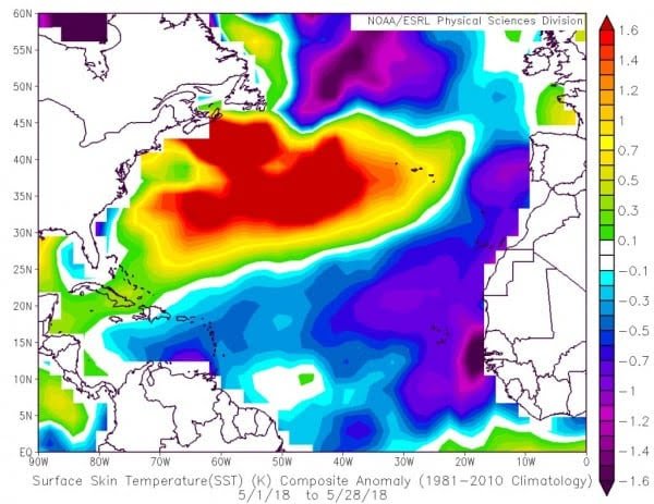
Sea surface temperature anomalies for the month of May 2018. (Courtesy NOAA).
The tropical North Atlantic and areas near the equator, where hurricane formation is likely, are cooler than average for this time of the year; especially off the west coast of Africa where temperatures are close to 2 degrees cooler than normal. According to Philip Klotzbach these cool temperatures have not been seen since 1994 and could have major impacts on the 2018 Atlantic Hurricane Season. This could be a major reason as to why forecast models and meteorological agencies are lowering their hurricane forecasts.
Additionally, there is still the idea of an el Niño forming later into the fall season. If this happens it will suppress formation of hurricanes at the time of the peak activity months (September and October). With the open Atlantic experiencing cold temperatures and the possibility of an el Niño forming it could be a potentially quiet hurricane season. However, chances of an el Niño developing are quite low due to the lingering la Niña still in place in the eastern Pacific.
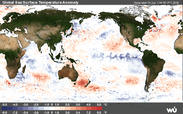
Sea surface temperature anomalies globally. Take note of the cooler temperatures off the west coast of South America (Courtesy Weather Underground).
Relating to the image above. Notice the blue swirl pattern coming off west South America. This is a la Niña event which cools the Pacific and hinders cyclone formation in this region. This “cool phase” has been in place since last hurricane season (2017) and produced less cyclone frequency in the Pacific basin. However, this has the opposite affect in the Atlantic. Instead of cool sea surface temperatures, the Atlantic warms up and we see an increase in frequency and strength of hurricanes in the Atlantic during a la Niña year. This phenomenon is what helped the 2017 Atlantic Hurricane Season to become so active and destructive. Once this la Niña transforms into an el Niño event (the swirl off South America will turn red in colour) the opposite will occur. The Atlantic will become less active while the Pacific becomes more active with hurricane formation.
What could happen is that we have a quiet start to the season (Alberto being the exception). June and maybe July could be less active as sea surface temperatures slowly warm up. August is generally where the North Atlantic starts producing higher amounts of cyclones and even major hurricanes. If the la Niña persists in the Pacific this may be the time that hurricane activity will increase across the ocean basin. However, if by some lucky chance an el Niño begins to take shape it may help to suppress the formation of hurricanes further for the peak months of September and October. Unfortunately there is no guarantee of this happening as meteorologists and climatologists have a minimal understanding on the el Niño and la Niña phenomenon (known as the El Niño Southern Oscillation). Throughout the season meteorologists and forecasters will continue to monitor the sea surface temperatures, wind shear levels, and potential el Niño formation and update their hurricane forecasts. Currently we are expecting a near average season and the possibility of a moderately active one for 2018. There is no way to forecast where these storms will form or where they will impact. Even during quiet seasons, one major hurricane can form and cause immense devastation, as seen in 1992 with Hurricane Andrew which formed during a quiet hurricane season. Therefore, regardless of how active a season is forecasted to be there is always the chance of a powerful hurricane coming ashore. The best advice is to prepare now. The 2017 Atlantic Hurricane Season is still fresh in our minds, especially for the victims of Hurricane’s: Irma, Harvey, Maria, and Nate. 2017 proved that we need to always be prepared for the next storm.
Citations:
- Wenckstern, E (2018). The strangeness of Alberto: Making history over Great Lakes. The Weather Network.