Pacific Hurricane Season 2015
Remnants of Patricia Still Alive and Moving Eastward. Say Hello to Patricia’s Extratropical Form!
October 26, 2015; 9:00 PM EST
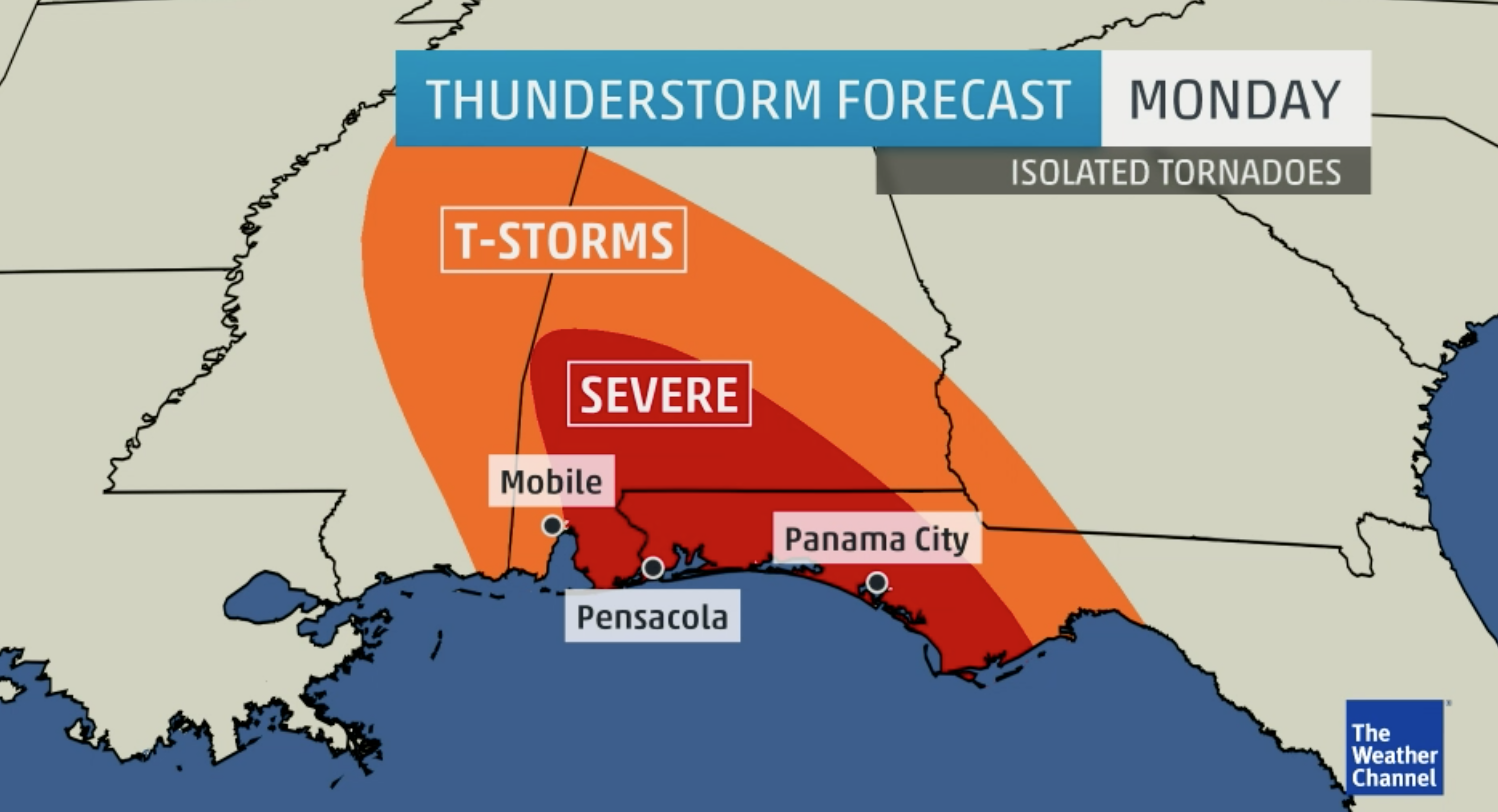
It’s not out of the ordinary that a Hurricane Patricia is still haunting us from the grave. Although Patricia is not classified as a hurricane or a tropical storm anymore she is still tracking eastward as a tropical low. However, the rain keeps falling and there is even some signs of connectivity in the bands. Parts of southern Alabama and the panhandle of Florida are under a severe thunderstorm watch for this even as the remnants of Patricia push through.
Southern Louisiana saw high precipitation values over 8 inches yesterday with some areas breaking rainfall records. Tornadoes have also been spotted across Louisiana promoting several tornado warnings. Two EF0 tornadoes were confirmed.
The tornado threat remains tonight in Florida and rain is still a big issue with the remnants of Patricia. Most of the heavy precipitation is lingering offshore west Florida but will be approaching the shorelines soon.
You can still see that there is a bit of a spin on Patricia and can almost locate the low pressure center of this system (located approximately to the right of Baton Rouge Louisiana, just offshore south of Alabama). However, you all may think this storm is over, but it is not. Patricia has one more trick up her sleeve and I am surprised no one is talking about on the news. Patricia is undergoing extratropical transition allowing her to grow in size. Already, Patricia was a monster storm when she came ashore in western Mexico a few days ago, now she is about 10 times bigger!
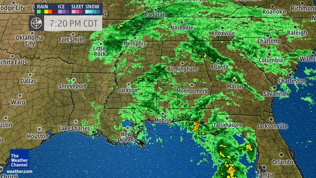
Look at this image! This was taken at about 18:00z time. Patricia is massive and her cloud cover extends far to the north-northeast! I am so excited for this because it shows just how powerful Patricia was when she made landfall and how she has managed to stay in this tropical form for so long to now be undergoing extratropical transition over land. Basically what is happening (if you don’t keep up with my extratropical discussions found in the Atlantic Hurricane Season blog) is that Patricia is becoming a cold core system and is developing a front. She is loosing her tropical warm core characteristics and transforming herself to better adapt to the environment. In one way she is evolving in order to stay alive now that her main energy (warm temperatures of the ocean) has been cut off. This process is known as extratropical transition.
Over the next few hours it won’t be Alabama and Florida that have to worry about this storm. The whole east coast will be experiencing some rain and wind. Below is an animation showing the GFS model and the precipitation values that are expected for the next few days. As you can see from the animation it began with only Texas getting the majority of the rain. This was because Patricia was still in her tropical form. Mostly compact and maintaining its warm tropical core (much smaller than a cold core system). However, as the animation progressed the rain covers much of the east coast, and this gives us a fairly good view of the way Patricia is growing and undergoing her transformation into a n extratropical storm.
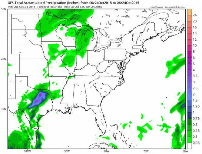
(Click the image above to see the animation)
So everyone along the east coast gets to experience just a small piece of this historic storm before she moves offshore in the Atlantic and says goodbye, leaving lots of memories behind.
Patricia a Tropical Depression but Rain Remains
October 25, 2015; 10:55 am EST
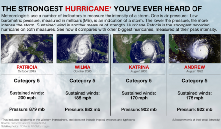
Yes that is right, we have a new queen for most powerful hurricane in the western hemisphere. Wilma kept her reign for 10 years but she was dethroned. Also important to note is that only Patricia and Andrew made landfall at Category 5 strength. Wilma and Katrina reached their peak strength in open water before weakening and then making landfall. Also, anyone notice that 3 years ago Sandy was being broadcasted as the largest hurricane to have formed in the Atlantic? Same date as Patricia is making history? Something about October 23-24. In my opinion it might have to be called the new “peak” of hurricane season.
Let’s take a look back at what happened yesterday after residents in the Mexican state of Jalisco woke up to see the first signs of damage from Patricia:
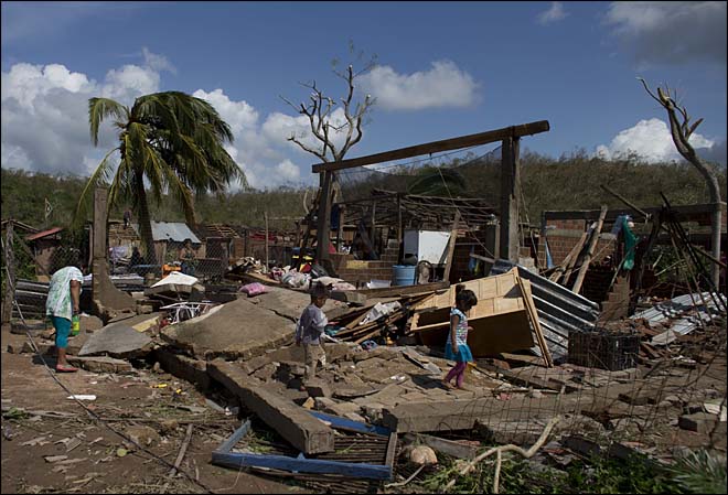
(Photo Courtesy of Katie and Herb Hunter/VisitLaManzanilla.com)
Typical site to wake up to after a huge and powerful hurricane moving through your area. Many structures have been damages and numerous trees have blown down but here is the most impressive news: so far not one fatality has been reported! Bizarre right? It all has to do with where Patricia struck. True this hurricane was a monster in size and in strength but forecasters are always concerned with the eye wall, the area that houses the highest wind speeds and therefore produces the most wind damage.
So here are the factors that saved countless lives; first, Patricia came ashore to the south of the popular destination town of Puerto Vallarta. This area is sparsely populated. If this storm came ashore in Puerto Vallarta a whole different story would probably unfold due to the high population in this area because it is a vacation resort town; Two, the position of the storm relative to Mexico. In the Atlantic Basin we have a big problem when storms come ashore and that is because one of the first parts of a hurricane to come ashore is the strongest quadrant which houses the deadly storm surge. This is the top-left part of a hurricane. However, when a hurricane approaches the west coast of Mexico this quadrant is usually the last to make an impact and this is what saved the coast lines here. The hurricane did come ashore as a category 5, however, once ashore the high mountain areas began to tear the storm apart and quickly weaken it. By the time the top-left quadrant of the storm made it to the shoreline storm surge wasn’t a big problem; Three, the size of Patricia. Patricia was a large storm as seen from the figure below:

(Photo Courtesy of the National Hurricane Center)
Category 5 winds only extended out about 15-20 miles from the eye (common for most intense hurricanes). However, hurricane strength winds extended out over 250 miles from the eye. Therefore, from this point winds from 74 mph to 200 mph would be expected (higher wind speeds as you get closer to the eye). However, let’s take a look outside of the circle indicating the hurricane winds. White. Lots of white. Meaning lots of clouds and therefore a lot of rain. This is one of the many reasons I cannot stand the Saffir-Simpson Scale, it only deals with wind and not with rain (hint: my PhD is focused on destroying this scale).While forecasters and government agencies were breaching about how bad the wind was they did not make the time to show how large this storm was and how much rain is being withheld in this system. If you take a look through all the damage photos that are coming in from this system it is not the wind that is the major problem, it is the rain. Mudslides and landslides are a huge concern right now, and I am willing to bet that in the coming days these will be the main causes of death in the area. Water is always the number one killer in a hurricane, not the wind. In fact, the structures in this area were built well to withstand the winds from Patricia. Also, look at the vegetation in the area. Sure the banana crop industry is suffering but most of the native trees – the palm trees – are still standing. Fascinating trees really. They have adapted to violent hurricanes and their wind speeds. They can bend at extraordinary angels and still manage to bounce back and stay alive. So thanks to these amazing trees we did not have to worry about them flying into people’s roofs. Four, the forward speed of the system. This storm was moving relatively fast. If this system moved slowly the damage would have been worse and structures may not have withstood the onslaught of the storm for more hours. Residents estimated that the worst of the storm took about 5 hours to pass. This is about average for most hurricane that hit an area. Five, we have the government of Mexico to thank. Usually we direct our hate to the government after a hurricane has passed saying that they did not do enough. However, Mexican authorities days before this event knew they were going to get struck and that it would be serious. Evacuations were ordered swiftly and many people did in fact get out of the storm’s path (best example here of preparedness). Shelters were opened and many hotels prepared for the worst and moved their guests to safer areas. So please give a round of applause to the Mexican government and authorities for being well prepared and informed about Patricia.
These are the main factors that contributed to the zero death count in Mexico. However, this is not an official fact yet. Many areas are still unreachable and telephone towers are down in many of the areas. I believe the next few days will be the deadliest part of the storm and this is the threat of land and mudslides. This will be a secondary affect from Patricia but thanks to this hurricane the mountains are very unstable after being saturated with so much rain.
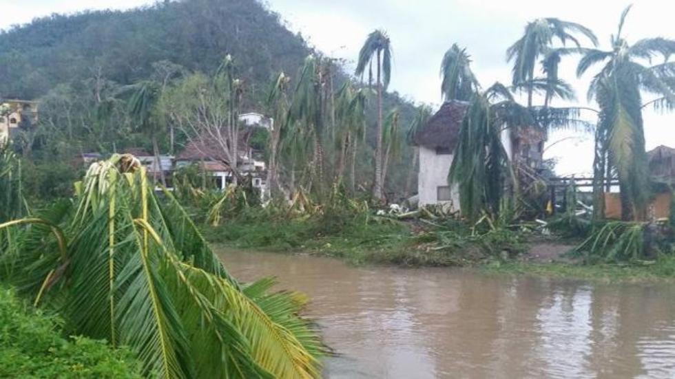
Cleanup is underway in Mexico as people pick up their personal items and sweep the mud off the street. Some dedicated people are even back to work selling fruit and fish on the side of the road. Very impressive. These Mexican are strong and brave to survive such a powerful storm and then get right back to everyday life the next day. Several airports have re-opened starting this morning.
Now, let’s talk about the big state of Texas. Well you guys can’t say I didn’t warn you. I said two days ago it was coming at you in my previous blog updates. Immense flooding is expected in south – southeast Texas for the next 24-36 hours as the remnants of Patricia move eastward. Even though the winds have died down to a tropical depression the rain still remains and there is a lot of it.
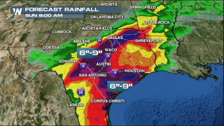
Heavy rainfall will be excluded to the south of Texas with precipitation values reaching as high as 10 inches in some areas.Heavy rains have already forced parts of the Brazos River out of its banks. Many homes along this river are threatened, especially homes located in the small community just outside of Waco, Texas. Galveston County Judge Mark Henry on Saturday issued a voluntary evacuation for Bolivar Peninsula after forecasters released a statement calling for tide of up to 1.5 meters high and almost 12 inches of rain. However, many will probably ignore the warning and stay. Well now the pressure is on USA, if we get even one death from Patricia in her tropical depression status then we are just very sad people compared to all the Mexicans that survived her in her Category 5 status (shaking head) don’t disappoint me.
Rains will push off into Louisiana and Arkansas today and continue moving eastward for the next few days as Patricia continues to weaken. I leave you all with one more nice image showing the wind flow of Hurricane Patricia on October 23 when she was her strongest.

A beautiful and frightening image showing just how close together these wind fields are as the swirl into Patricia towards her center. That dark red in the center indicating winds of 200 mph is still so impressive. We will probably never see a hurricane with this wind speed again for a long time.
Another big round of applause for Mexico for having survived the strongest hurricane to ever threaten and impact the western hemisphere.
Patricia Makes History Part 2
October 23, 2015 9:58 pm EST
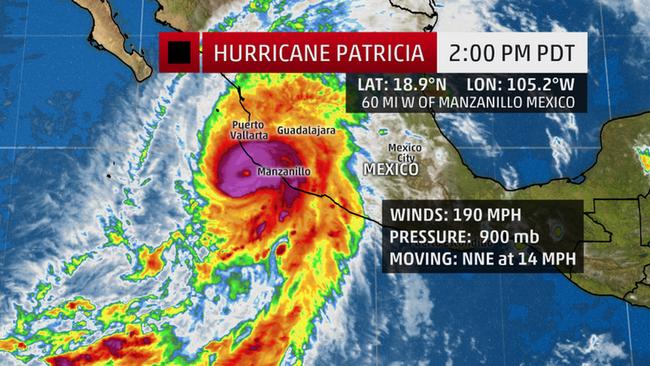
Here is the latest update on Patricia. The strongest hurricane ever recorded in the east Pacific has made landfall at 6:15 pm local time (7:15 pm EST). Winds of 165 mph blasted through the southwestern Mexican coast near the town of Cuixmala. Pressure is slowly rising indicating that weakening has already begun. As of the latest advisory the central barometric pressure in Patricia is 924 mb. A huge difference from it’s world record of 879 mb this morning. Winds are slowly dying to 160 mph, but this is still a strong Category 5 storm!
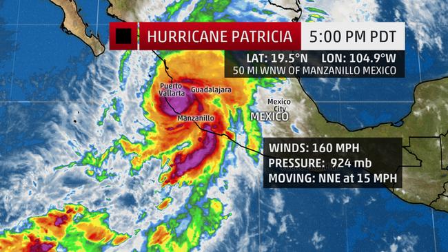
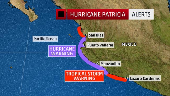
Hurricane warnings and watches continue to remain up for the majority of the coast lines in Mexico and will continue to remain up for the next 24 hours. The government encourages people to remain where they are and to not venture outside.
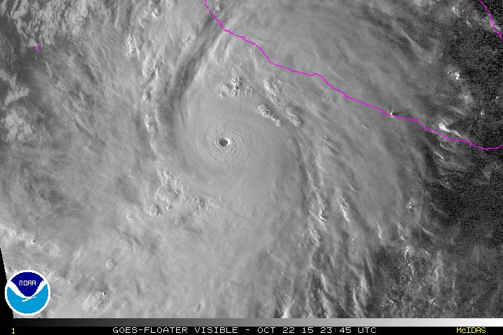
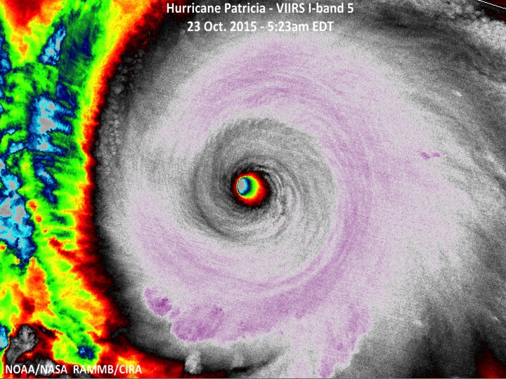
Let’s take a quick look back at Hurricane Patricia from this morning. I never got to go into detail due to the fact I am attending a conference. However, let’s look at the structure of this hurricane.The figure below (left) is a satellite image of Patricia from this morning. If you look closely at the cloud formations around the eye you can see some “ripples.” These “ripples” do not show up unless the storm is very powerful. This indicates that the winds in the higher levels of the atmosphere are moving so fast towards the center of the eye. This indicates that wind speed values are reaching such insane speeds that the clouds are being torn party the force of this wind speed. The National Hurricane Center has determined that near the center of the eye this morning wind speeds reached a maximum of 200 mph. This would mean that Hurricane Patricia has the highest wind speeds ever recorded. However, I need to make sure everyone understands that this hurricane is not the most powerful hurricane in the world. It is only the most powerful hurricane recorded in the east Pacific basin and the Atlantic basin. The record for the strongest hurricane in the world still belong to Super Typhoon (1979) Tip which has a barometric pressure that was 870 mb (Tip was also the largest hurricane ever recorded). Although Tip only had wind speeds at 190 mph (compared to the estimated 200 mph from Patricia), it is the barometric pressure that determines the power and strength of the hurricane (ignore the Saffir-Simpson Scale). Finally, the image to the right gives another view of Patricia to basically show how solid and compact this storm really is. The eye is perfectly open and the solid black circle encompassing the eye is basically giving us an idea on how high these clouds are and how fast they are spinning. The area that is hit with the eye wall will indeed have the most damage and possibly the most casualties.
The Mexican government has so far informed the world that the small fishing villages along the coast and some popular tourist destinations bore the brunt of Patricia. For over 24 hours the Mexican government has been encouraging the people along the coast lines to evacuate out of Patricia’s way. Tourists along the coast have been placed in temporary shelters while the storm rages.
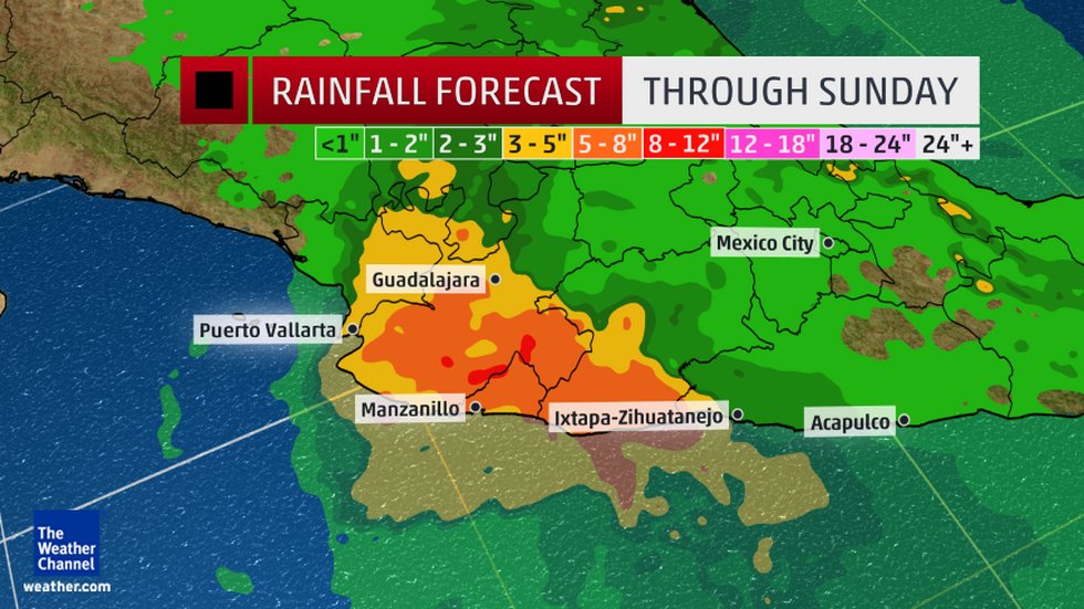
The major concern with Patricia is not only the deadly storm surge but the rainfall amounts. The majority of the impacted area will see values ranging from 5 to 8 inches however, areas could see values that are higher, up to 12 inches. As this storm weakens it could produce more rain for areas further inland and even as far away as the United States in the coming days. The winds may decrease and the central pressure may rise but the rains will continue to hang around the area of low pressure. In the next few days there will be many areas that will be experiencing flooding problems even though Patricia may degenerate to a tropical storm or even a tropical depression.
Patricia will slowly continue her journey inland for the next few couple of days, losing the majority of her strength now that there is no warm water to help fuel her. However, this storm is so strong (still maintaining Category 5 strength as of the 5 pm advisory) that it is not losing it’s strength and energy fast enough. The director of Mexico’s National Commission for Water, Robert Ramirez de la Parra, said: “The hurricane is so big and so intense that it has the capacity to pass over both the Sierra Madres in our country — that is, through our most mountainous ranges — and then exit the country on the other side into the north part of the Gulf of Mexico and possibly the United States.” (CNN News) The agency reported that when Patricia came ashore early this evening the eye of the hurricane was estimated to have a diameter of 10 kilometers (about 6.20 miles).
Currently, we have no word from Mexico regarding the storm’s destruction. Communication will be down for the next few hours and we can only imagine what the people and country are going through. Storm surge is expected to be the number 1 killer along the coast, but even more dangerous will be landslides, especially in the mountainous areas. Wind damage will also be a problem (though the flooding will be more of an issue due to the immense size of Patricia). Areas along the coast will be the most vulnerable, especially structures that are not well built or able to withstand 200 mph gusts.
To survive a hurricane of this intensity and this scale residents need to be taking shelter in a solid concrete structure far away from the shoreline. This is the best chance for survival. To put this into perspective Hurricane Patricia is more powerful than Hurricane Camille (1969) and Hurricane Andrew (1992), both which made landfall as Category 5 hurricanes. And, Patricia is more powerful (and likely to cause more damage and destruction) than Hurricane Katrina (2005). The World Meteorological Organization tweeted that Patricia’s intensity is comparable to Typhoon Haiyan, which devastated the Philippines and left over 6,000 people dead. West Pacific Basin hurricanes (known as Typhoons) tend to be more powerful than their counterparts on the east side of the Pacific and in the Atlantic. In one way we can say that Patricia is one of these “Super Typhoons” that areas like Taiwan, the Philippines, and Japan experience. However, outside of these areas powerful hurricanes on that scale have never occur, until now. It appears the el Niño is really giving a nasty dose of steroids to these hurricanes this year, especially in the Pacific.
Prayers and blessings to those in the path of this destructive storm. Damage photos and casualty estimates will start to come through in the next few hours and this will be painful to view. Regardless of what happens this storm will be making history both meteorologically and in regard to damage and loss of life.
Patricia Makes History Part 1
October 23, 2015 5:50 pm EST
It’s the topic everyone has been talking about all over the world today, Hurricane Patricia. Patricia is the strongest hurricane that the National Hurricane Center has tracked in recorded history. And this is one deadly storm.
Forecasts have been fairly accurate over the past few days, however, no one predicted that this storm would intensify this much. We have the “Godzilla el Niño” (yes, that is what climatologists and meteorologists are referring it as) to thank for this monster storm. The waters off the west coast of Mexico and South America have been warmer than usual and have contributed to all the hurricane activity that we have been seeing this past hurricane season. It is not uncommon for the west coast of Mexico to get a direct impact from a hurricane, although the majority of hurricanes that do form tend to stay out to sea and move towards Hawai’i. The storms that do hit this part of Mexico will usually be weak (below Category 3, typically). So it comes as a major shock that such an intense Category 5 storm is now barreling down on the Jalisco state of Mexico.
Hurricane Patricia reached a record breaking 879 mb reading early this morning, the pressure is currently holding at 900 mb (as of the 2pm advisory) as it takes aim at making landfall. Hurricane Patricia is expected to make landfall somewhere along the coast of the Jalisco state between 6 and 7 pm EST. However, the area has already been experiencing the effects of Patricia since early this morning with wind speeds already gusting to 100 kmh (62 mph).

Forecasts are still predicting that Patricia will maintain its strength as the eyewall passes over land. The storm is struggling a bit as it is now approaching land. Currently the wind speeds are down to 190 mph and the pressure has since risen. It is possible for the storm to downgrade to a Category 4 storm, but either way this storm will be making history both now and in the next few hours as damage reports and casualties start coming through.
As the storm moves inland over the next 24 to 36 hours it will weaken considerably, thanks to the mountainous region. However, even with the higher elevation helping to break the hurricane apart this storm is expected to still be a major Category 3 storm further inland.
The Mexican government has warned the residents for the past 24 hours to get out of harms way and evacuate further inland. The National Hurricane Center warns that the storm surge, along the coast especially, could be catastrophic. Landslides will be a huge concern due to Mexico’s mountainous terrain. Poorly built structures will not hold up when Patricia makes landfall. Wind speeds of over 200 mph will be expected this evening.
The best place to be is in a solid concrete structure away from the coast. No other place will be safe. This situation is the worst-case scenario and we are about to witness the power of this storm.
What is up with the Aloha State?
August 28, 2015 10:51 pm EST
Many would believe that Hawaii is an active hurricane spot. It’s an series of islands in the tropics, surrounded by warm water, beautiful skies, fantastic waves. Basically people think that if an area is considered “paradise” it must be hit by hurricanes. Yes and no.
Hawai’i has been hit by hurricanes in the past and have been brushed by them from time to time. However, Hawai’i is not an active hurricane destination. This has a lot to do with the location and size of the islands. Hawai’i is so small that most of the time hurricanes miss them just by luck. Below is a figure showing the tracks of hurricanes that have approached the Hawaiian Islands since 1949:

All of these line tracks may seem to be a lot, but this is data going back over 60 years. So really Hawaii does not see too many hurricanes.
The last time Hawai’i received a devastating hurricane was back in 1992. Hurricane Iniki was a very rare and strong category 4 hurricane that devastated the island of Kaua’i. It remains the most powerful hurricane to strike Hawai’i in recorded history.
Enough about history and statistics, let’s take a look at what Hawai’i is dealing with right now:
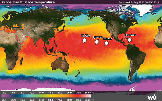
It continues to be active in the Pacific compared to the Atlantic. This has to do with the el Niño event that is currently ongoing. The Pacific is in a “warmer than normal phase” which is providing extra fuel to systems in this basin. Along with warmer sea surface temperatures, there is a minimal amount of wind shear taking place in the atmosphere (if you want more information on el Niño please take a look under the climate change blog) . All of the ingredients are perfect for hurricanes to form in the Pacific this year and Hawai’i has been busy dodging hurricane after hurricane.
Hawaii has two current storms to worry about: Ignacio and Jimena.
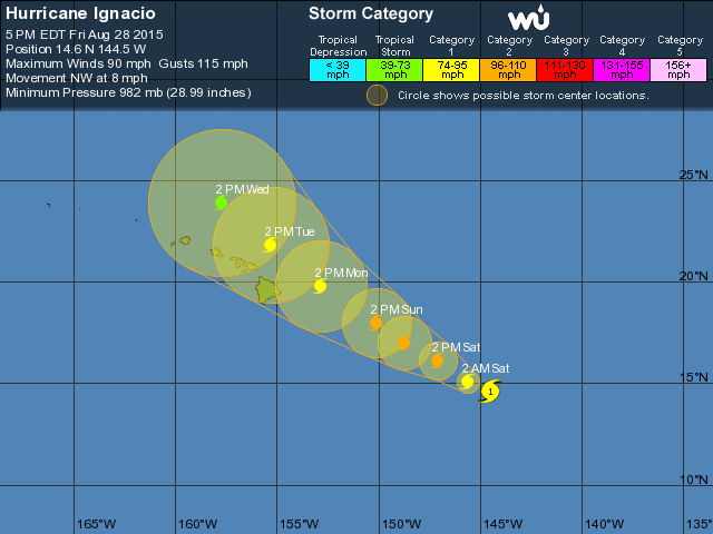
Let us start with Ignacio which is closest to the Big Island of Hawai’i. This is a relatively small system, but don’t let the size fool you. This system is strengthening and very well organized at the moment. Currently packing speeds at 90 mph, Ignacio is currently in a very warm area with minimal wind shear and is using this environment to strengthen as it drifts off the the NW at a very slow 5-10 mph. This will not last long though. Ignacio will pick up speed in the next couple of days and enter into an area of cooler sea surface temperatures (in the lower 70’s). This will cause Ignacio to struggle and weaken. Models are forecasting that the storm will stay north of the islands and weaken. However, this does not mean Hawai’i is safe. Although a direct impact is not expected, the outer bands will be brushing the islands. The Big island of Hawai’i will get the majority of the moisture accompanied with this system. Areas at higher elevations (especially around Kilauea) should monitor the conditions closely. These areas will be prone to landslides. Low lying areas need to be concerned about flooding. The main concern will be the waves associated with this system. Waves from the storm are already rolling into Hawai’i, which the surfers are probably loving. However, the majority of deaths that occur in a hurricane are due to drowning! No matter how good a swimmer you are, get out of the water as this storm passes through.

Finally, we have one more storm: Jimena. This is a problem storm. Jimena is like the evil shadow of Ignacio. This system is very well organized and the eye is very solid. The winds are going around so fast in the eye wall that it makes a perfect open circle in the center. The thunderstorms are all packed into the area surrounding the eye and helping the system grow stronger. At the moment Jimena is only a category 2, but this system will strengthen in the next 24-36 hours. Jimena is in a perfect area for development. Warm sea surface temperatures, minimal shear, and as a bonus there is Ignacio ahead. Hurricanes can be brutal to each other when they are close to each other. As Jimena follows Ignacio she slowly sucks up the energy left behind by Ignacio. Ignacio on the other hand is busy being “the mother” in a way. Ignacio carves out a path for Jimena to follow. If a disturbance, such as wind shear, comes along and rips apart Ignacio, Jimena will just come up behind it and suck the remaining parts of Ignacio into itself. In a way we can say hurricanes are cannibals. However, in very rare cases, two hurricanes may interact with each other and orbit around one another. This battle for dominance is known as a “Fujiwhara effect.” Ignacio and Jimena are not that close to undergo this rare effect, however. More likely, Jimena will be feeding off of Ignacio’s energy for the time being.
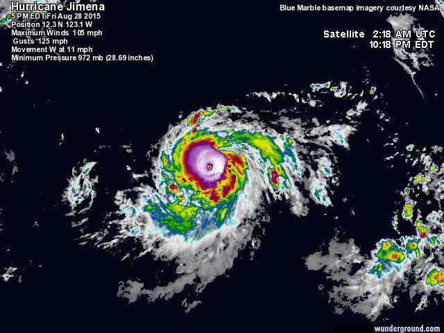
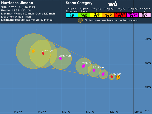
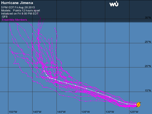
So what can we expect from Jimena? At the moment, she is way out at sea drifting slowly west at 11 mph. Strengthening is expected with this system over the next few days. However, come Monday night and Tuesday morning, Jimena will be in the approximate spot that Ignacio is currently in. Sea surface temperatures will be cooler and wind shear values will be increasing allowing some weakening to occur within Jimena. Jimena is expected to follow the same path as Ignacio over the next few days before turning more northward. GFS models are currently in agreement that Jimena will be pushed northward and further away from the Aloha State. This is still several days out, however. As we all know, forecasts change constantly.
So Hawai’i may be having a tough 2015 Hurricane Season but they are having good luck avoiding these systems. Hurricane Season is not over yet for the Pacific. With the way the el Niño event has been going the past few months, Hawai’i could see more hurricanes approach. My advice to everyone, especially the hard-core surfers: get out of the water! Even if a hurricane is still out at sea, or just brushes the islands, rip currents are present. You do not want to be sucked under or dragged out to sea. Just wait until the hurricane has passed. Did I mention there are tons of Tiger Sharks waiting for you if you choose to swim in a hurricane? No one will want to save you from a shark attack and a hurricane at the same time. At least no one I know of….
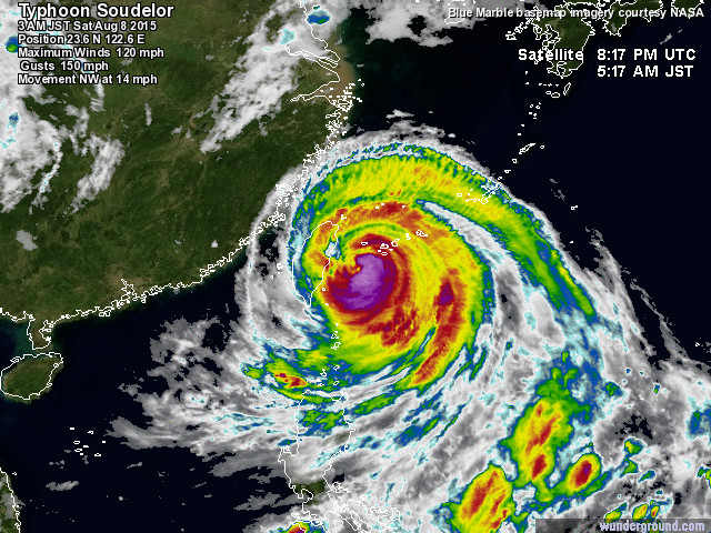
Typhoon Soudelor
(Photo courtesy of WeatherUnderground)
While the Atlantic Basin remains quiet this hurricane season, our attention is focused on the Pacific Basin. Typhoon Soudelor has made a direct landfall on the island of Taiwan. The storm made landfall equivalent to a category 3 storm (according to the Saffir-Simpson Hurricane Scale) with winds of 120 mph (193 km/h). Soudelor made landfall on the northeast part of Taiwan just north of the city of Hualien early Saturday morning. Storm is currently moving WNW at 15 mph across the island.
The main threat with Soudelor will be rain and flooding. This is a fairly large system and thus rain will be more of a threat than the winds. Mountainous areas will receive the brunt of the wind and landslides will be a major threat. Low lying areas can see rainfall values over 300 mm.
The majority of the population in Taiwan is distributed along the western part of the island. Probably due to the fact that the east side of Taiwan is hit so often by typhoons. The east side of the island is mostly rural and mountainous.
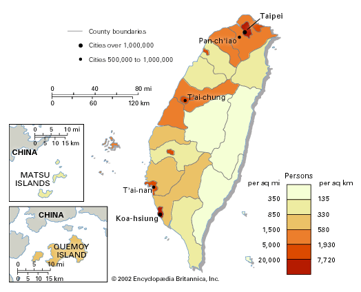
(Photo courtesy of Encyclopedia Britannica)
Taipei is the major city in Taiwan with the majority of the population residing in this mega city. Taipei could possibly experience the eyewall going right over the city in the next few hours. Major threats will be heavy rainfall and gusty winds exceeding 100 mph.
Here is the good news: Radar and satellite images are showing the eye shrinking and disappearing from the center of the storm. This is probably due to the interaction with land which is cutting off moisture to the storm. This is a sign of weakening (no, we are not looking at an eyewall replacement cycle). Soudelor is still a strong category 3 storm and could maintain its strength as it passes through Taiwan and back out into the ocean and taking aim at China.
Taiwan is a strong country that has managed to survive countless typhoons making a direct impact on the island. Each typhoon that impacts the island only makes the people stronger. Prayers are with the people on the island.
Side note: Many news stations have been reporting Typhoon Soudelor as the “strongest storm on Earth.” Just to set things straight, this is not the strongest storm on earth ever recorded. This is the strongest storm that has formed during the 2015 Hurricane Season. The record for the strongest storm on earth EVER, still belongs to Super Typhoon Tip which occurred in October of 1979.