Atlantic Hurricane Season 2015
It’s Not Over Yet! Tropical Storm Kate Forms Near the Bahamas.
Nov 9, 2015 10:17 am EST
It has been a very long time since I blogged about a hurricane forming in the Atlantic. Everywhere else is seeing numerous hurricanes forming (particularly the Pacific and the Indian Ocean), but not the Atlantic. Not a surprise really, due to the wicked el Niño threatening all of us this year.
Let’s talk about this new system. For the past few days the National Hurricane Center has been keeping a close eye on this storm as it traveled across the Leeward Islands late last week. During that time the storm had about a 10% chance to form into a storm. This then turned into a 50% chance a few hours later as more convection was starting to occur near the center (AKA: storm getting bigger/more thunderstorms). Surprise! this morning we have Tropical Storm Kate.
What does irritate me from time to time is that when this system was being tracked it was considered to be a “tropical depression,” however, the National Hurricane Center refuses to use this terminology and just labels the area as a “potential area for development,”… kind of odd right? However, after a hurricane begins to dissipate THEN they label it as a tropical depression… not cool. The reason I bring this up is because during the time Kate was a “tropical depression” over the Lesser Antilles it brought excessive rainfall to the islands. Most of the rainfall fell Friday with some areas seeing 192.4 mm (7.57 inches) of rainfall. All this rain caused serious flooding throughout the island. So why not just label it as a “tropical depression” so that people will become more aware of the threat? <- Goddess Ranting


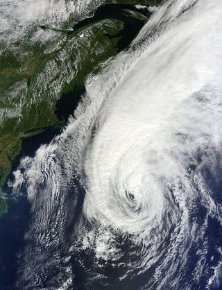
Looking at the satellite image above, this storm is fairly compact with numerous high-top thunderstorms near the center. Now you may think that the center of this system is in the middle of that pile of clouds. However, tropical storms are more disorganized compared to a solid hurricane. In this case, the center of Kate is located around the bottom left corner of this cloudy mess. This is most likely where the majority of the rain and winds are in this system at the moment as it continues to become more organized.
Here is the good news! The United States does not need to worry about this storm and we have the month of November to thank for this. Unless a hurricane forms in the Gulf of Mexico, it is very rare for a hurricane to make landfall during the month of November. This has to do with the upper level winds and how they shift starting in October. From June to around the beginning of October hurricanes follow a typical path forming in the Atlantic and traveling westward. True they usually curve away from the United States thanks to the Bermuda High Pressure system, but these are the months that the United States and Canada get hit by these storms. Starting in October there is a shift in the winds (literally). Storms that form in the Atlantic and especially in the Caribbean begin to travel eastward, back out to sea. This is good for us! This is what Kate will be doing over the next few days.
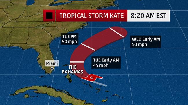
Kate right now is a fairly weak tropical storm, however, thanks to the warm air and water coming from around Florida this storm will increase slightly in strength. However, besides a few rip currents and large swells along the southern east coast, this storm will pose little risk to the United States.
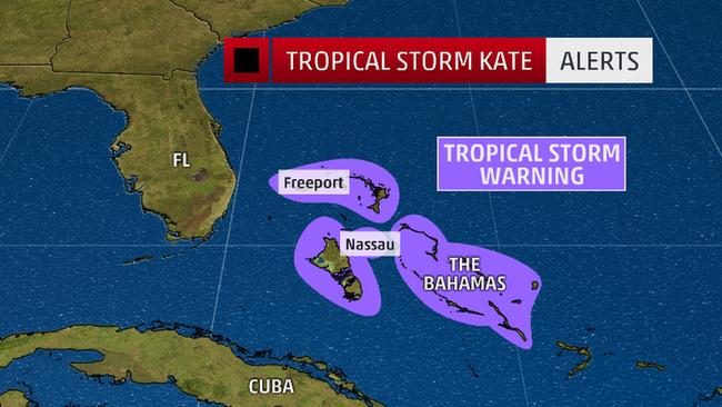
Tropical Storm warnings are up for the Bahamas, Nassau and Freeport. Rainfall totals of 2-4 inches are expected. However, this system is moving fast so these warnings will be lifted in the next 12-24 hours.
So not to worry if you are vacationing in Florida this week. Nothing to worry about. Watch out for rip currents and high waves from the system but Kate will not be visiting the United States. Bermuda may have to keep an eye on this storm in the next few days, but at the moment forecasts are showing Kate staying to the west of Bermuda.
The Carolinas are Drowning and Bermuda is Under Threat
October 4, 2015 2:05 PM EST
So we all think that Joaquin is out of the picture and we don’t need to worry anymore. However, surprise, surprise, Joaquin is actually causing a huge problem for the Carolinas. For the past week weather services have been warning people in this region to prepare for historic flooding. The Carolinas have been drenched all summer and now the ground is so saturated that any amount of additional rainfall could spell disaster.
Although Joaquin is far out and threatening Bermuda at the moment, the outer bands are being pulled to shore allowing tropical moisture to pour down on the Carolinas. I am going to relate back to this figure from a few days ago:
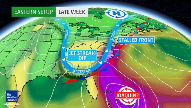
This was back when Joaquin was a strong category 4 storm in the Bahamas. However, the atmosphere has changed very little in the past few days. The jet stream is still way to the south and this is creating a stationary front which is hanging out right over the Carolinas. Also, take a look at the purple-like colors. This is tropical moisture from Joaquin. This moisture is being pulled by this stationary front and thus the rain just continues to fall over the Carolinas and Virginia. This rain is not expected to let up until Monday evening or Tuesday, when the jet stream finally shifts and moves back northward and Hurricane Joaquin moves further out to sea.
Currently the Carolinas (especially South Carolina) and Virginia are under state of emergencies. Many weather agencies are saying that this is the 1000 year flood. Many roads are underwater and people remain trapped in their houses throughout the state. The death toll is currently at 4 and is expected to rise in the coming days.
Finally let us talk about Hurricane Joaquin a little bit more. Joaquin is currently a strong Category 2 storm and is approaching Bermuda from the southwest. A Hurricane Warning is currently up for the island.
Bermuda is experiencing tropical storm force winds at the moment but should be experiencing hurricane wind forces in the next few hours. Although a direct impact is unlikely, the island will experience high winds, waves and precipitation until around Monday afternoon. However, lets take a look at the satellite imagery of the storm today:
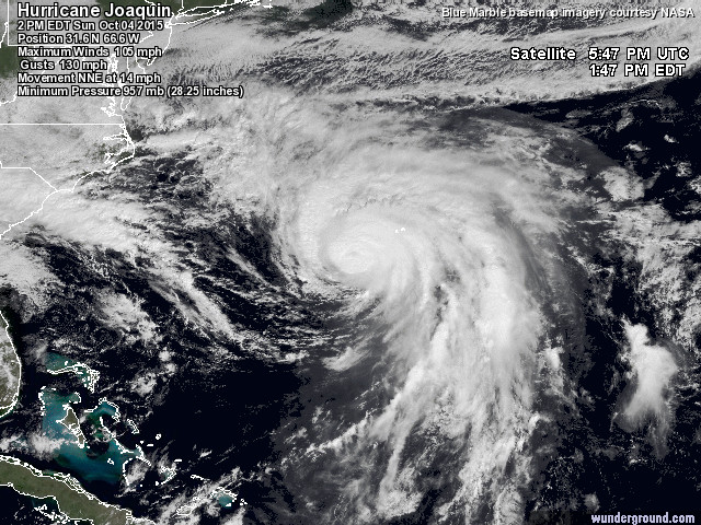
Joaquin is starting to grow. It was not this big when it was down by the Bahamas. This is a sign that extratropical transition is currently underway. Additionally, here is some more interesting news. Great Britain is starting to worry about this hurricane! Strange right? Not really. Many times hurricanes that turn back out to sea eventually hit Europe in some form. Most of the time these systems are so weak and full a cold-core storm that brings gusty winds and rain to the European nations. However, Joaquin is expected to impact Europe as very strong storm. Possibly a vigorous extratropical cyclone.
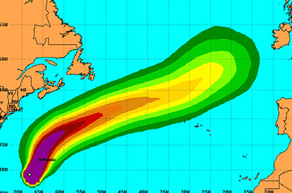
Currently, forecasts are showing Joaquin moving straight towards Great Britain. Many forecasters in this area are warning people saying this could be the worst storm Britain has seen in 30 years. Forecasters are determining that Joaquin will hold together and even strengthen after extratropical transition is completed. This will create a very wet and rainy scenario for Great Britain. This event will not take place until next weekend, however, a lot of time for a forecast to change. As we all know.
In the meantime Joaquin is enjoying his visit to Bermuda and the Carolinas continue to flood.
Joaquin is Pretty Much Killing Itself
October 2, 2015 9:55 pm EST
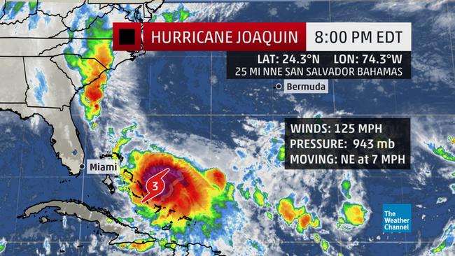
As of the 8pm advisory from the National Hurricane Center Hurricane Joaquin has lost strength and is now back as a Category 3 storm with winds of 125 mph. Pressure has risen slightly since yesterday and is now stable at 943 mb. However, Joaquin is still a major hurricane and continues to impact the Bahamas for, what is now, day three.
Rainfall totals are expected to be up to 25 inches on some of the islands by the time the storm finally moves away. Storm surge is still a major threat with areas seeing up to 6 feet of storm surge. We will not know the full details until the storm moves away and communication is restored to the islands.
The big news at the moment is that a U.S. cargo ship, El Faro, based out of Jacksonville Florida has been reported missing in the storm. The ship sent a distress signal earlier today to the U.S. Coast Guard. Immediately a C-130 search and rescue plane was dispatched, but was unable to make contact. 33 lives are onboard.
I keep telling people to stay out of the water and avoid rivers during hurricanes and severe weather, but this reaches a whole new level for me… why is a cargo ship hanging out in the middle of a major hurricane? It flabbergasts me.
Joaquin is finally moving northeastward and is slowly exiting the Bahamas. It is no surprise that Joaquin has weakened slightly. Over the past few days this storm has been sucking up all of the energy in this area. Due to the heavy amounts of rain and strong winds this storm basically made its surrounding environment cooler. When you go out in the rain it is cooler than going out in sunny weather. rain comes from high up in the atmosphere where is it relatively cold. This rain hits the Earth and cools the surrounding area. In the ocean, rain eventually cools the water temperature, especially if there is a lot of rain. This is what Joaquin has been doing. In a way, Joaquin is destroying itself. Without warm ocean waters (about 27 degrees celsius), Joaquin will struggle to remain a Category 3. However, now Joaquin has shifted and is moving into a new area. The good news is that this area will not provide much help to the storm. Over the next few days Joaquin will stay around a Category 3 storm (possibly weaken to a Category 2) as it tracks to the northeast.
The Bahamas will stay under hurricane warning for another 12-18 hours before the warning is lifted. Bermuda has been placed under a tropical storm watch today as the forecast for the storm has shifted more to the east. Luckily for us the Bermuda High Pressure is relatively small at the present time and this is dragging Joaquin away from the mainland United States and further out to sea before turning and moving back out to sea. However, before we all start celebrating, this does not mean we grab our beach towels and run to the beach. Let’s look at the satellite picture below:
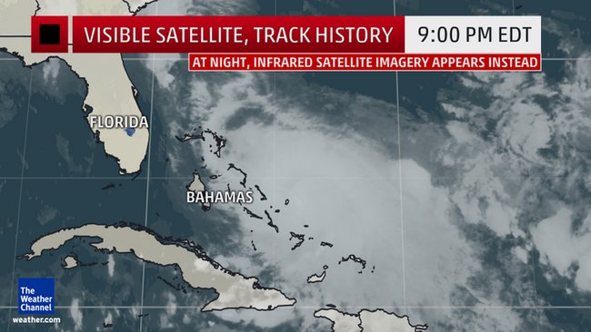
(Photos Courtesy of the Weather Channel)
Joaquin is not the pretty circular storm that it was yesterday. It is more of a squished storm where the majority of the system can be measured from west to east. Joaquin is struggling right now and may be starting the primary phase of extratropical transition. This will help the storm grow in size. Even though Joaquin is going out to sea much of the east coast will be receiving rain from the hurricane, as well as large waves.
We may not as much as Bermuda, but the east coast has been having a wet few weeks already. More rain could cause flash flooding and landslides closer to the Appalachian Mountains. Therefore, expect heavy amounts of rain up the east coast for the next few days.
Current track is showing Joaquin staying as a major hurricane until around Sunday (I would not be surprised if it weakens faster). Bermuda will receive gusty winds in the next few days. Rain showers expected for east coast, Nova Scotia and Newfoundland. The majority of the models are in agreement that Joaquin will stay away from the continental U.S. for the most part. Bermuda is now under threat (I am not expecting a huge impact for the island at the moment, unless something drastic happens).
Areas of Concern Currently:
East Coast (Carolinas up to Maine): Rain is still expected. Larger amounts of precipitation and historic flooding possible especially if extratropical transition takes place. Large swells and beach erosion still a big concern. Stay out of the water!
Atlantic Canada: Some rain expected.
Bermuda: Wind will be the primary concern for the island.
Prayers go to the people aboard the cargo ship El Faro. Hopefully contact is re-established soon.
Hurricane Joaquin Reaches Category 4 Strength
October 1, 2015 8:15PM EST
The Hurricane Hunters have been flying into Hurricane Joaquin all day today to determine if the storm has strengthened. Currently, they are still flying through the system dropping sondes (meteorological devices that measure, pressure, wind speed, location, etc.) to determine if further strengthening is possible. As of the 5:00 pm advisory, the National Hurricane Center confirms that Hurricane Joaquin is still a solid Category 4 system with winds of 130 mph. The movement continues to be tediously slow at 6 mph. This has been going on for the past couple of days and this is not helping the Bahama Islands.

The Bahamas have been under a hurricane warning for the past two days now and this warning will not be lifted for at least another day. The National Hurricane Center reports that some of the Bahama islands could see storm surge levels of 5 to 10 feet above normal. Rain values should be around with 10 to 15 inches (250 to 380 millimeters) in the central Bahamas.

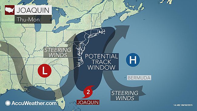
Joaquin will continue to drift south-eastward for another day coming close to the island of Nassau before shifting to a northward direction. This is the point the United States will be fearing. It is possible that Joaquin could make a direct landfall somewhere along the United States. However, the jet stream and the Bermuda high will have a big impact on the system. The jet stream continues to hang out in the south (thus is why I am freezing in Toronto right now even though it should still be warm). The jet stream is acting as a barrier and protecting Florida, Georgia and the Carolinas from a direct impact. The Bermuda High is going to be the key player for this hurricane. Hurricanes like to revolve around this high pressure system and are directed mostly from this system. The Bermuda High is situated somewhat close to the east coast of the United States. So Joaquin cannot move further out to sea and away from land. Instead it is revolving around the Bermuda High which is very close to shore at the moment. However, the Bermuda High is circular (blob-like really). Once Joaquin reaches the “top” of the circular high it will be directed toward the northeast and away from land. The main problem is the size of the Bermuda High. This high pressure system changes shape and size constantly, it never remains the same. Usually around hurricane season it is relatively large and hangs out around Bermuda (such is the name). It is thanks to this high pressure system that we are having trouble forecasting exactly where Joaquin will go. We are trying to determine when Joaquin will reach the “top” of the high pressure system and start curving back out to sea. However, Joaquin is located at the very bottom of the Bermuda High and has nowhere to go but northward as the jet stream and the Bermuda High “squeeze” this system and keep it trapped close to the east coast.

Figure above: Jet Stream is denoted by the “L”, acting as a barrier to areas like Florida and Georgia. “H” denoted the Bermuda High Pressure. Joaquin is trapped and has nowhere to go but up.
So here is what residents along the east coast should know: you will get rain (please, you all knew this). However, I am not saying you will get a little rain shower. You will get a lot of rain. Some areas will see historical amounts of rain. Parts of the Carolinas should be very concerned due to recent amounts of heavy rains. Flooding is a real threat with Joaquin. This will be the main concern for the United States all up the east coast.
This storm has a high chance of undergoing extratropical transition (I am saying that it will undergo extratropical transition for sure). When this happens the storm will grow to be about 10x bigger than its tropical form. This will be the cause for historical rains and flooding in some areas.
Weakening is expected with this system, but this is only based on the Saffir-Simpson Wind Scale. The winds will decrease in strength, the rains will increase, especially with extratropical transition taking place. Ignore the categorization of the storm and worry more about the rains associated with the system.
Joaquin is expected to weaken as it moves into cooler waters. Forecasts are calling for Joaquin to be about Tropical Storm strength status as it approaches Massachusetts on Tuesday.

Regardless if Joaquin makes landfall or not, the United States will have deadly impacts in the coming days. The precipitation and flood threat will be the greatest. Now is the time to evacuate if you are in a hazardous area that is prone to flash flooding and sea level rise from storm surge. Make arrangements for pets if you have not done so. Do not leave them behind!
Nova Scotia, be prepared, this storm has a high chance of impacting you directly by the middle of next week. Although only a tropical storm it will bring high winds to the east of the province with more rain to the west of the province.
My last warning: everyone from Florida to Maine… for the next few days… get out of the water! Don’t prove that you can survive the high waves and rip currents of a hurricane, you will loose… you will always loose. And, I don’t want to include anyone in my death counts when I am doing my research. It gives me more work to do and it saddens me.
Areas of concern currently:
Carolinas: Historic flooding and beach erosion
Chesapeake Bay Region: Storm surge threat.
Rhode Island and Massachusetts: Possible direct impact
Nova Scotia: Direct Impact possible
The Weather Goddess will continue to keep you updated on Hurricane Joaquin and where it is heading.
Next advisory from the Hurricane Center will be up around 11pm EST.
Joaquin Now a Major Hurricane
September 30, 2015 11:56 pm EST
As of the 11pm advisory from the National Hurricane Center, Joaquin has reached category 3 status on the Saffir-Simpson Scale making it a major hurricane.
Winds are currently at 115 mph and the storm is continuing a south-west direction at 6 mph. Very solid storm with heavy thunderstorm activity.
Hurricane warning remain up for the Bahamas as they are pounded with immense rain and intense winds with gusts reaching up to 140 mph at times.
Additional strengthening is likely in the next 24-36 hours. Joaquin could very well reach category 4 status. East coast remains under high alert as this storm is about to take a more northward direction and head up the east coast. Areas from Virginia to New York are the major target areas at the moment.
Now is the time to act and prepare for Joaquin. This will likely be the major storm of the year.
Current main threats for the East Coast:
- Heavy rains (especially if extratropical transition takes place). Flash flooding will be a major problem.
- High winds. East coast should prepare to see a storm of about category 1 – 2 strength at the moment.
- Storm surge; especially areas along the shoreline and the Chesapeake Bay region.
Joaquin Takes Aim at East Coast
September 30, 2015 1:42 pm EST
It has been a quiet few weeks, which is strange given the fact that September is usually the most active month for hurricanes to form. All of this ends now. We have two areas to worry about. Let’s start with the most important matter: Hurricane Joaquin. The National Hurricane Center upgraded the wave a couple of days ago to tropical storm status and since then Joaquin has been “vacationing” down around the Bahamas. However, because this system was almost stationary for the past few days it has had the chance to strengthen thanks to the warm ocean temperatures and the minimal amounts of wind shear in the atmosphere.
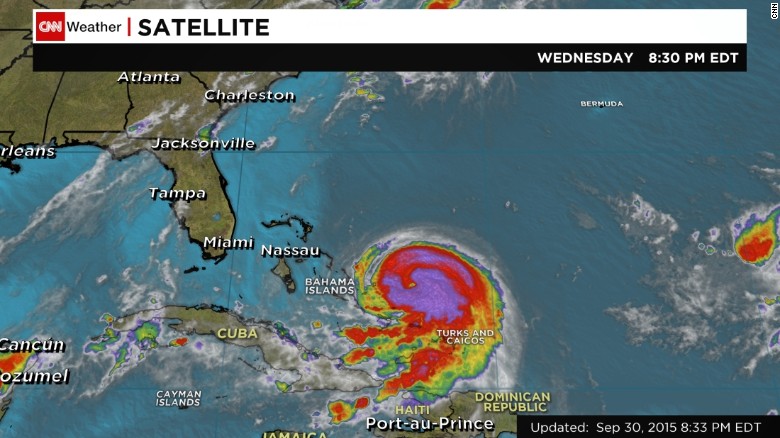
Currently Joaquin is a solid category 1 hurricane with winds of 80 mph. This system is strengthening though, and fast. This is a well formed system that is showing no signs of weakening or dissipation in its form as seen from the satellite image below.
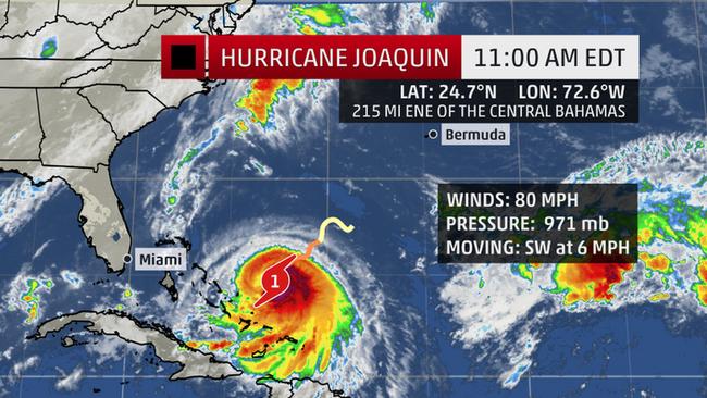
What is concerning is that Joaquin is moving very slowly south-west and is storing as much energy as possible in preparation for its journey northward in the next 12-18 hours. Joaquin has nowhere to go but northward and this is thanks to the Bermuda High just to the right of Joaquin, which acts as a steering mechanism for the hurricane, and the low jet stream dip happening to the left of the hurricane, blocking it from moving more westward.
This is a typical meteorological process that happens around late September and October. From June to September hurricane flow in a more westward direction, however, come October the pattern shifts and we find more storms heading away from areas like the Gulf of Mexico and instead they turn more northward and eastward, back out to sea. However, many people (especially in New England) are biting their nails off because Joaquin is showing a very similar track to another storm we experienced not too long ago: Sandy.
“Frankenstorm” Sandy (one of the many nicknames), started out in a very similar fashion as Joaquin. Staying in the Caribbean, building up strength until it was a Category 3 storm and then began to move northward. Upon landfall, Sandy completed extratropical transition and was a vigorous extratropical cyclone retaining winds of a category 1 storm. This big problem with this storm was the storm surge.
Many are now concerned that we will see a repeat of Sandy. It is true that we should be concerned with any system that threatens to make landfall, however, Joaquin is more complicated to forecast at the moment. Unlike, Sandy (which we knew for days would impact New England), meteorologists are still unsure about where Joaquin is going. True, we know that this system will be moving northward, but at the moment we are having trouble with forecasting the jet stream and the stalled front that is accompanying the jet stream.
(Photo courtesy of the Weather Channel)
This front could keep Joaquin away from shore and spare us a direct impact. However, this does not mean that we will be seeing blue skies and birds chirping. Rain and winds will still be effecting the New England area no matter what. Joaquin, like Sandy, will more than likely undergo extratropical transition in the next few days as it works its way northward. This transformation will increase the size of Joaquin. The main concern will be the rain if this is the case. The high winds will be felt on the right side of the storm (which will be offshore), the rain will be on the left side, over land.
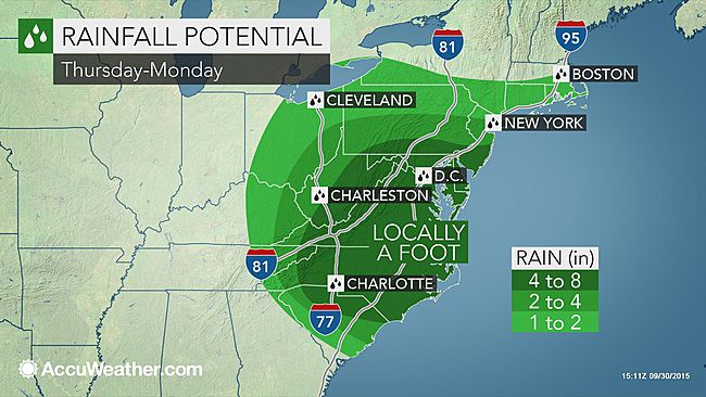
Currently, forecasts are calling for heavy amounts of precipitation of the weekend Maryland and Virginia seeing the most amount of rain. This forecast will change in the coming hours to days as we receive more information regarding where Joaquin will be heading. The National Oceanic and Atmospheric Administration (NOAA) has put up their latest track forecast:

We all know from experience (at least those who stare at weather charts all day) that the cone of uncertainty will be shifting a lot over the next few days. Currently NOAA is forecasting Joaquin as staying on a northward track before shifting slightly to the west making landfall in Delaware. This is the worst-case scenario (NOAA loves to scare us). There is a high possibility that the stationary front and the jet stream will retreat back to the north allowing Joaquin to shift more to the west and collide with land. What is scaring most of us is that this system is strengthening and it is expected to reach major hurricane status (category 3) . This intensity will not last long due to the fact that Joaquin will be entering cooler waters and will start to undergo extratropical transition which will put a lot of stress on the system. By the time Joaquin reached New England it will be around a strong category 1 hurricane.
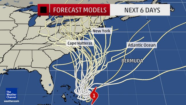
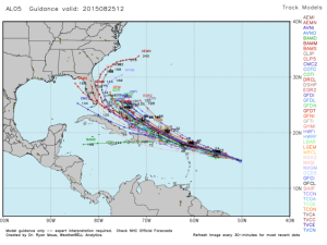
Above are different forecast models showing where Joaquin is projected to go over the next few days. There is a lot of disagreement at the moment with many showing Joaquin making landfall somewhere along the east coast and a few showing that Joaquin will miss the US completely.
More information will become readily available in the coming hours and days as all eyes focus on Joaquin. No matter what, the east coast will receive heavy rains from Joaquin and rough surf along the coast lines, even if this system does not make a direct hit. I know a lot of surfers in Florida have been enjoying the large swells over the past few days, but as this system gets closer to the shoreline the swells will become larger and more violent. Stay out of the water for the next couple of days, especially when Joaquin shifts to a more northward track.
Finally, if this system does make a direct landfall, storm surge will be a problem, especially for areas located on the top left side of the storm. Also, residents along the Chesapeake Bay should be cautious now. Regardless on the direction of this storm, water levels will rise in the bay. In addition, if landfall occurs in this area, I advise to evacuate. This area will receive large storm surge values due to the fact that water will be pushed in swiftly and have nowhere to go but inland. This is the area that I am most concerned about at the moment.
Currently Hurricane Watches and Warnings have been issued for the islands in the Bahamas as Joaquin continues to hang out and enjoy the warm waters. Flooding is the main concern for the islands right now.
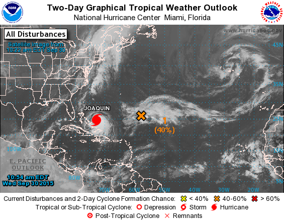
Finally, we take a look at another disturbance hanging out in the Atlantic. This disturbance is not very organized at the moment but it is forecasted to become stronger in the next few days. Currently, there is a 40% chance of development in the next 48 hours and a 70% chance of development in the next 5 days. However, this system will stay far away from shore and will make room for Joaquin as it travels northward. For the moment this system is not a threat to us (unless you are deep sea fishing WAY out there).
Should we Prepare to Meet Ida and Joaquin?
September 16, 2015 12:35 pm EST
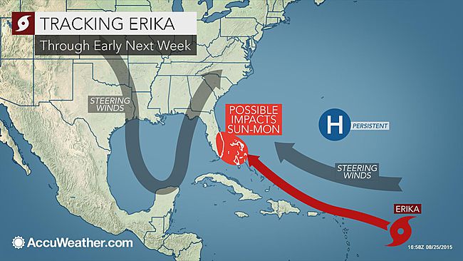
All seems to be going well this hurricane season. We had one scare with Tropical Storm Erika back in August, but so far North America has been spared any direct impacts from a hurricane. The majority of storms that have been forming this year are of Tropical Storm strength status. This is to be expected because of the strong el Niño that is currently in place causing a lot of problems for Atlantic storms to develop and strengthen. However, it is September, the peak month for hurricane activity. So far September is living up to this title.
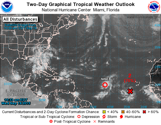
As of this week we have two tropical waves in the Atlantic Ocean. At the 11am advisory, the National Hurricane Center upgraded one of these waves to “Tropical Depression Nine.” Following behind this depression is a weaker wave with a 70% chance of development in the next 24 hours (and an 80% chance of development for the next 5 days).
Let’s take a closer look at these storms and see what is going on with their development:

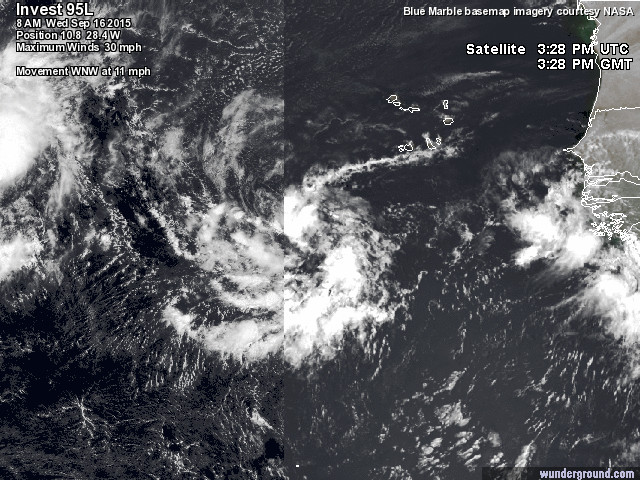
Above, on the left, we have our new depression and on the right we have the wave that has a high chance to develop into a stronger system. Starting with Tropical Depression Nine: this system is becoming more organized and is even showing signs of a low pressure center. The National Hurricane Center has determined the strength of this system using their trusty “Dvorak Technique” (another topic I can rant on for hours). Following very close behind Tropical Depression Nine is another tropical wave, which compared to the other storm does not look as organized. We can clearly see that thunderstorm activity is trying to wrap around the storm and create a low pressure center, but this storm is having a tough time. A lot of it has to do with the proximity of these two storms. These storms are close enough that a Fujiwhara Effect could occur. However, with both of these systems being so weak this effect may not be so dramatic. The more likely case is that these two systems will feed off of each others energy and prevent the other from strengthening.
Meteorologists have been following these two systems for a couple of days since they exited the west coast of Africa. Due to the fact that these systems have formed close to Africa they are known as “Cape Verde Storms.” Cape Verde Storms usually follow a typical westward path before (usually) curving north when the reach the Caribbean Islands. These two systems are not expected to take this typical pathway, however.

Above, on the left, we have the forecasted track for Tropical Depression Nine. This system is expected to meander out in the Atlantic Ocean for a while as it drifts northwestward towards the island of Bermuda. The good news is that this system is not expected to upgrade to a tropical storm for the moment. This has to do with the wave following behind, sucking up any energy from the Tropical Depression, as well as the wind shear values in this area.
Above is the wind shear values for September 16, 2015. Red and white areas are high shear, blue and green are low wind shear values. Currently, the two storms are hanging around south of the Cape Verde Islands, thus avoiding the high levels of wind shear just to the north of them. However, as Tropical depression nine heads northward it will begin to encounter these high winds which will probably result in the death of the system.
Looking at the forecast models for each system now. Models are in disagreement on where Tropical Depression Nine (left figure above) will ultimately go. They all agree that this northward motion is imminent, but they are not sure on if it stays on this northward path or if it diverts to the east or west. This is not a big deal, due to the fact that this is a relatively weak system and will struggle over the next few days.
As for the other wave following behind the depression, models are mostly in agreement that it will travel west- northwest over the next few days. This system will move northward into this area of high wind shear values and could bring about the destruction of this storm. For the most part, both of these storms are expected to stay fairly weak and not impact any land for the foreseeable future.
Henri is Chilling by Bermuda and Transforming!
September 10, 2015 11:23 am
First off I would like to say happy peak of hurricane season to everyone out there! September 10 has been known to be the peak of the Atlantic hurricane season due to the fact that it is around this time when conditions in the atmosphere and ocean temperatures reach the perfect conditions for hurricanes to form. It is around this time when hurricanes start forming more frequently.
(Figure courtesy of the National Oceanic and Atmospheric Administration)
Luckily we only have one hurricane spinning out in the Atlantic at this time and that is Henri. Am I the only one who thinks it should have a “y” instead of an “i” at the end?
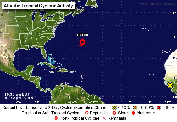
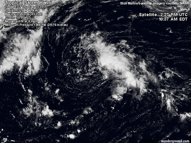
Henri is currently having a fun time out by Bermuda but is posing no threat to the island as it continues a northward journey. Looking at the satellite picture above Henri is not impressive at all (sorry Henri). If you look closely there is certainly a circulation around a low pressure center, but the thunderstorm activity is very minimal and is shifting to the right of the storm. This shift in thunderstorm activity is a sign that Henri is starting to undergo extratropical transition (please refer to my publication on extratropical transition or if you don’t like my nerdy talk there is always Environment Canada). By the time hurricanes move into subtropical waters they sometimes go through a change in their core and structure. Instead of the maximum winds being located close to the center of the system and the moisture located throughout the storm, the wind and moisture will separate and be located either on one side or the other. Typically, the strong winds will be located on the right side and the rain will be on the left side of the storm. Additionally, during the transformation the hurricane will grow to be 10x larger in some cases and grow a “tail”. This “tail” is a front and this appears when the hurricane is finished undergoing extratropical transition. The hurricane is no longer referred to as a tropical system or even a hurricane at this point. Instead the National Hurricane Center will drop all warnings/watches and start referring to it as an extratropical system. I could go on about how wrong this is, but that should be saved for another time… or just read my article to hear about my rant. 🙁
So here is an example of a hurricane (Hurricane Igor (2010)) that underwent extratropical transition:
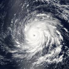
On the left we have Igor (2010) down in the warm waters close to the Leeward Islands. As you can see Igor, at the time, was a perfect circular system with a well defined eye. Classic example of what a hurricane should look like. However, now look to the right… different right? This is still Igor, however now it is off the coast of New England and traveling to the northeast. Igor is now not perfectly circular, it is instead becoming more elongated. The majority of the moisture (denoted from the clouds) is being pushed to the left, and the high winds are being pushed to the right. You can clearly see this long “tail” (the front) extending from the left side of the eye and going northward. At this time Igor was undergoing extratropical transition. Igor was not classified as extratropical until it was right off the coast of St. John’s, Newfoundland. The eye disappeared from satellite imagery and Igor became a very elongated and vigorous extratropical cyclone that devastated the island of Newfound.
This is just an example, to show the difference between a tropical hurricane and a hurricane undergoing extratropical transition. However, many people are under the impression that once a hurricane undergoes this transition and is labeled as “extratropical” that it is no longer dangerous (here comes my small rant). This is false on so many levels. Once a hurricane completes its transition it still retains the wind speeds from when it was in it’s tropical form. In many cases they come out stronger. Finally, more moisture is harbored within an extratropical storm compared to its tropical state. This is because it grows to be about 10x larger when undergoing extratropical transition. Therefore, just because your local meteorologist says that the storm is now extratropical does not mean it is safe to go sailing the 7 seas.
Ok, so we got off track a bit. Back to Henri. This system will be heading north-northeast for the next couple of days and could slightly impact the island of Newfoundland by this weekend. However, Henri is very unhealthy at the moment and could die out very quickly. The biggest impact will be some rough seas and rip tides along Nova Scotia and Newfoundland and a couple inches of rain at best. Henri is currently a weak tropical storm and could maintain his strength for a couple more days before completing extratropical transition and moving out to sea towards Europe. Models are in a agreement that Henri will stay mainly away from Newfoundland and any other land masses.
So not an active week so far in the Atlantic, but if that makes you sad and bored you can always check out the Pacific Ocean. I can’t tell you how jealous I am off researchers studying hurricanes in the Pacific this year. So many! We can all thank el Niño for this.
Graceful Grace Forms
September 6, 2015 10:19am EST
It comes as no surprise to the meteorological community that the tropical depression that was coming off Africa just a few days ago has now formed into Tropical Storm Grace. In my opinion, Grace looked much healthier looking a few days back when she was coming off Africa. Never-the-less, Grace has reached speeds equated to a stable tropical storm.
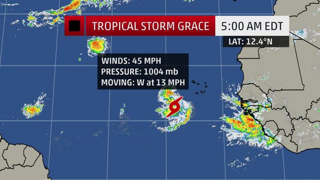
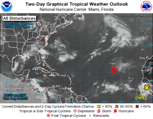
As mentioned in my previous entry, Grace is more of a threat compared to Hurricane Fred (which is still managing to hold on). Unlike Fred, Grace formed to the south of Cape Verde Islands. From my experience forecasting and tracking hurricanes, storms that form closer to the equator have a higher probability of traveling in a direct westward direction towards the Leeward Islands. This is what we are expecting from Grace over the next few days. She is currently moving west at 10-15 mph. For the moment we can all enjoy our long labor day weekend, but come next Friday (September 11) we may have to keep a closer eye on the storm.
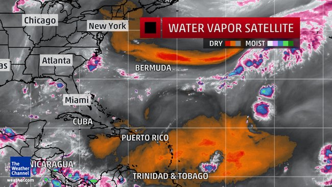
So what kind of environment is Grace going to be entering in the next few days? Below shows the water vapor satellite imagery for the north Atlantic basin. Looking at the image you can make out a little bit of Grace in the bottom right hand corner. Currently she is in a “stable” moist area (shown in gray, blue and purple are very moist areas) and she will continue to remain in this area. However, if Grace continues on this westward course, she will be interacting with a large area of dry air (shown in orange and red). This area has caused many problems for the past few hurricanes that have formed this year. None have managed to escape this harsh environment as they are choked by the dry air. This will be Grace’s biggest problem over the next few days.
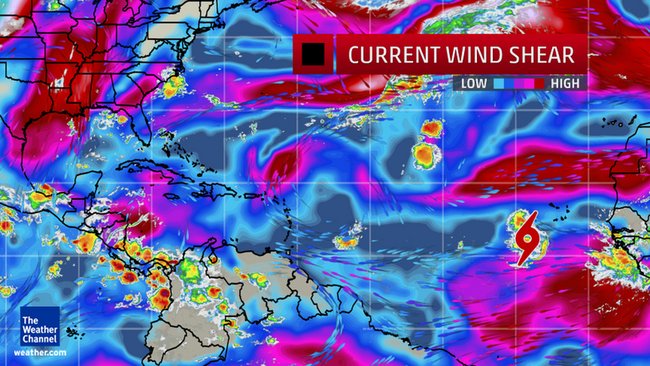
However, let us now take a look at the wind shear values that Grace will be encountering. Below shows the latest wind shear imagery in the Atlantic, and it seems Grace is in a perfect area for development. She is squeezed perfectly in-between two large areas of high wind shear (shown in red). However, she manages to stay just far enough away in the blue (low wind shear values) that she is not threatened. If Grace continues on her westward path she will not be encountering much wind shear at all over the next couple of days. With very little wind shear, Grace will be in a prime location to strengthen.
Currently, Grace is in a favorable area for development and is expected to strengthen over the next day or two. Grace has one major thing to worry about and that is the dry air located just to the west of her. This large patch of dry air could be the force that kills Grace. However, the atmosphere is never stationary, it is always moving. This area of dry air could always shrink and move off to the west giving Grace more room to “breathe.”
Meteorologists are keeping a close eye on Grace and the Leeward Islands may yet again be preparing for another tropical storm by late next week. The peak of Hurricane Season 2015 is approaching fast (September 10), and it is coinciding nicely with the frequency of storms that have been forming. I end on a final note: what is up with our old friend Fred?

Can you believe that Fred is still hanging in there? Fred has been hanging out in the center of the Atlantic for a few days now and refuses to die off completely. Although downgraded to a tropical depression, Fred may come back to life again in the next few days.
Fred will continue on his northeastward journey and head towards the Azores Islands before turning back southward (if he even lasts this long). However, this area is very moist with very little wind shear. If Fred can survive for just a little bit longer, we could see him restrengthen back into a tropical storm. The only component working against Fred is the temperature of the ocean. Fred is no longer in warm tropical waters, instead he is feeling the cool waters further to the north. Not the best place for hurricanes to be. Fred may need to get used to these cooler temperatures if he wants to survive.
What is Brewing Off Africa?
September 3, 2015 11:27 am EST
We are approaching the peak of Hurricane Season (September 10) and the hurricanes seem to know it. Over the past few days there has been a slow moving disturbance crossing over central west Africa. Even over land these intense storms have held together long enough to exit into the Atlantic Ocean. Today this disturbance was upgraded to a tropical depression. Although this system has about a 10% chance to increase in strength over the next 24 hours and become Tropical Storm Grace (I must say, I like that name), just take a look below at the satellite imagery of this storm.
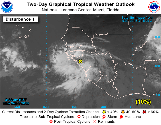
This system is already so well formed and it is starting to obtain the classic “spin” to it. This disturbance is in a favorable area at the moment with minimal wind shear as seen from the vertical wind shear maps below. Red and orange areas have less wind shear compared to blue areas allowing for hurricanes to survive and possibly evolve faster.
Figure above shows observed wind shear values for September 2, 2015. Courtesy of NOAA.
Unlike Hurricane Fred which sliced through the Cape Verde Islands just a few days ago, this system is to the south of the islands and will likely not impact them. Instead this system will travel WNW over the next couple of days. Speaking of Fred, let’s take a look at where he is now. Fred is struggling considerably as he continues his adventure in the Atlantic. Fred has lost a lot of strength and is currently a weak tropical storm. Upon closer inspection you can see that the thunderstorms and high cloud tops of this storm are being sheared apart from the high winds. Additionally, Fred is moving northward into cooler waters which is cutting off any chance of strengthening. Fred is not expected to survive for much longer. Now is the time to start ordering roses for the funeral.
Finally, we could possibly see this system coming off of Africa to strengthen into a tropical storm soon. If it does it will be considered a Cape Verde Hurricane. Due to the fact that this system is to the south of the Cape Verde Islands and thus closer to the equator, it may move on a more westward direction compared to Fred which favored a more northerly direction. I will continue to monitor the storm and bring you the latest news!
Fred and the Cape Verde Islands
August 31, 2015 10:42 pm EST
Hurricane Season 2015 seems to finally be on a roll now, we have hurricane Fred spinning in the Atlantic. Now before we all panic and issue more “state of emergencies” we should note that Fred is completely on the opposite side of the Atlantic. For the past few days meteorologists have been watching a strong wave come off of Africa and head westward. This wave had a strong chance of development and, by golly, it developed fast.
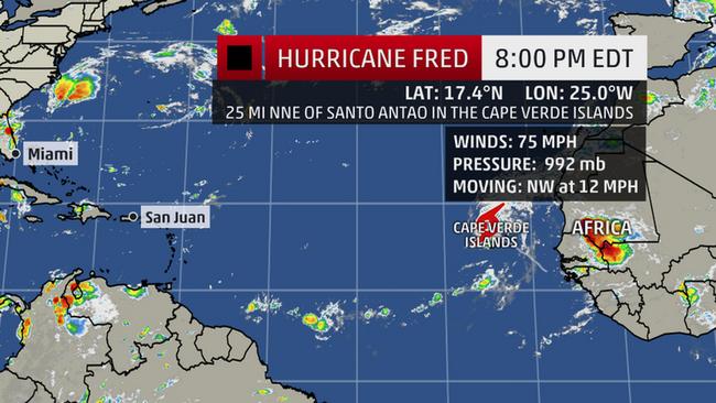
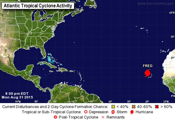
Fred is currently a solid Category 1 storm with winds calculated at 75 mph, but it is fairly small in size and moving rapidly WNW at 12 mph. What is so strange is where this hurricane is located. The Cape Verde Islands are being slammed by this storm which is not common. Cape Verde has seen many storms coming off of Africa but these storms are in a developing stage. Cape Verde usually sees storms that are tropical depression status and sometimes tropical storm strength. It is quite peculiar that the islands are dealing with a hurricane. The last time Cape Verde experienced a hurricane was all the way back in 1892.
When Fred directly impacted the islands it was a strong category 1 storm with winds of 85 mph. Hurricane Warnings continue to be up for the islands overnight and into tomorrow morning. These islands are volcanic islands, so similar to Hawaii, they have many tall peaks and mountainous terrain making them susceptible to flash flooding and mudslides. Locals on the islands have been told to expect flooding and high windlass Fred continues to exit the islands. Rainfall values could reach 10 inches in some areas.
After Fred visits the Cape Verde Islands he will move out into open water and turn more northwest. This will keep Fred far away from land and potentially weaken the storm rapidly. Fred is unlikely to grow past category 1 strength and is expected to weaken as it enters an unfavorable area for development. However, Fred did a good job terrorizing the Cape Verde Islands for a brief few hours. Plus, Fred broke a record! Fred became the eastern-most hurricane that has ever formed.
RIP Erika
August 29, 2015 9:37 pm EST
Well she had a good run, but I am sorry to say that Erika did not make it through the night. This was not surprise at all. Erika has been tracking over the mountains of the Dominican and Cuba for the past couple of days. Additionally, she was not in a favorable environment to develop due to high wind shear levels.
The National Hurricane Center downgraded Erika to a tropical depression this morning at the 9 am advisory. Hurricane Hunters flew into the storm and found that the center of circulation was very disorganized and tropical storm force winds were no longer detected. This is not to say that Erika won’t restrengthen back into a tropical storm, but this is very unlikely. Erika has basically been stripped apart, so re-organizing will be very difficult.
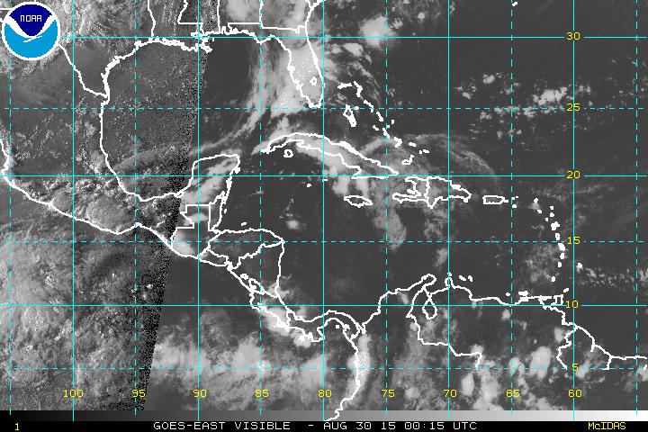
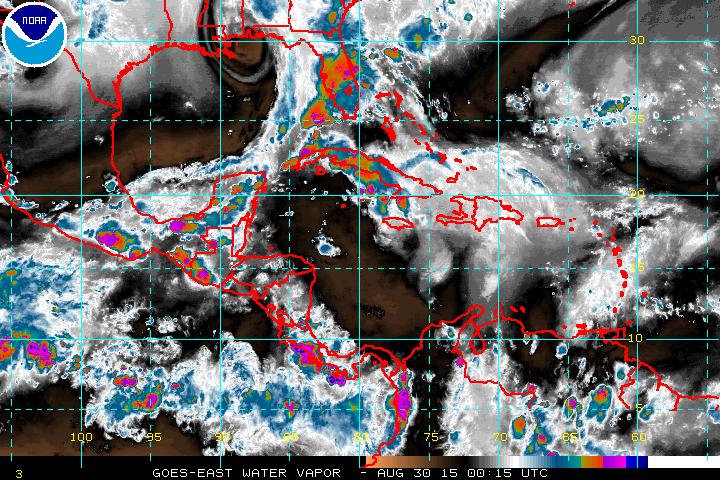
Figures above show visible and moisture satellite imagery of the west Atlantic basin. The remains of Erika are located around central and western Cuba and is slowly starting to turn northward up into the western part of Florida.
Florida probably feels a bit embarrassed for making a big deal about Erika, especially with issuing the “state of emergency” which made people start to panic. However, we cannot say that Florida was wrong in this situation. Erika was the first storm in 10 years to pose an immediate threat to Florida (Florida hasn’t experienced a hurricane since 2005). Government officials want to issue these warnings way in advance so that it gives the public time to prepare. They do not want to wait until the last minute, which will just cause chaos. So many residents may be upset that they had to dish out $$$ for water and canned food, but guess what? That stuff won’t spoil, and now the residents will be prepared for the next storm. So look on the bright side.
There is, however, a downside to the government issuing a “state of emergency.” This is the “crying wolf” scenario. If weather and government services start issuing warnings and gets the public scared, soon no one will believe them. Personally I am surprised that Florida issued a state of emergency so soon. Erika has been struggling for days and the chance of it reaching category 1 strength was minimal. However, I am not a political person and would be in a tough situation if I had to issue the big emergency signal (I like to think of it as a big red button… maybe in the shape of a hurricane symbol).
Even though Erika is now a depression we should not take her lightly. The moisture from Erika is still heading towards western Florida. Tampa is a place to worry about because of all the rain that has been accumulating in this area the past few months. Flooding is still a major threat for several areas up the west coast of Florida. I encourage the residents of Florida to remain aware that the rains from the remnants of Erika could still pose a threat.
Finally, rip currents will continue across Florida and the Caribbean Islands for a few more days. Please be cautious of tides and waves if you are traveling to the coast and in rivers. It would be wise to just stay out of the water until the depression has passed.
Hurricane Season 2015 is still ongoing so we are not done yet. Already there is a system coming off of the west coast of Africa. I will be monitoring this system closely over the next few days. Perhaps there is the potential for development.
Erika: Track Shifts West
August 28, 2015 9:44 pm EST
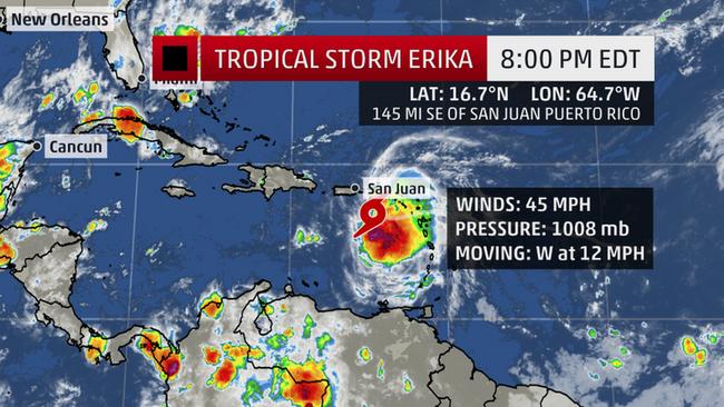
Today we probably all woke up to expect the track of Erika not to change much during the overnight hours. Sadly, mother nature loves to torture the meteorologists. Erika continues to weaken considerably and Puerto Rico is to thank for this. The island of Puerto Rico has mountainous areas especially in the central part of the nation. The heavy thunderstorms of Erika came into contact with these mountainous areas and helped to tear her apart. Looking at the latest satellite imagery Erika appears to be splitting, with thunderstorms retreating to the south. Winds are currently at 45 mph and the forward speed is west at 15mph.
The heaviest rains and flooding threats are still located on the ENE side of the system, but these thunderstorms are struggling to grow, especially as it now impacts the Dominican Republic. Erika continues to hang out in this very unfavorable area and this is contributing to the weakening of this system. It will not be a surprise if Erika downgrades to a tropical depression overnight as it crosses the Dominican Republic and extreme eastern Cuba.
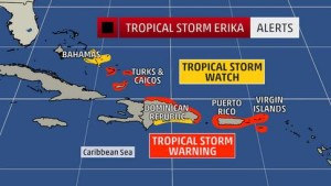
The death toll has climbed to 12 (and this is expected to rise) in the Caribbean and there are reports of people still missing. Coastal areas of Puerto Rico sustained major flooding and some structural collapses along the island have been reported. Tropical Storm Warnings continue to remain in effect for the Caribbean islands, with Tropical Storm Watches being poster for the Bahamas.
Now we get to the annoying part involving the state of Florida. So what happened with the track forecast? Most of us on the east side of Florida have been grinding our teeth and getting ready to face the “big bad storm.” The topography of Puerto Rico has a lot to do with this change. Thanks to the mountainous areas on the island the center of circulation on Erika shifted further south. You can think of a hurricane as having a mind of its own in a way. A hurricane wants to remain over water and gather energy, but once it hits land it begins to struggle and a lot of the time the center of circulation, or the “eye”, will disappear or shift slightly.
Another factor is the jet stream. For the past several days the jet stream has come down into the gulf states and acted as a barrier to Erika, keeping her further to the east. The jet stream has begun to retreat back to the north and is allowing Erika a small bit of leeway. Thus, the forecast and the cone of uncertainty has shifted west.
The state of Florida has sounded the alarm and has issued a state of emergency (they are so excited). Watches and warning for the state will be issued in the next 24-36 hours as Erika approaches. I will say this now: the storm is now close enough for me to give a more accurate forecast. If Erika survives over the Dominican it will be a very weak tropical storm or even a tropical depression by the time it exits back into a water environment. Extreme south Florida will feel the effects first starting Sunday afternoon into the evening. The Keys need to be prepared right now, this system is coming in this direction and regardless of a direct hit flooding will be the big issue. Evacuation orders are currently being issued for some of the islands and more evacuation orders will be issued in the coming days leading up to the storm.
After the Keys, Tampa needs to be on high alert. Tampa is right in the center of the cone of uncertanty for Monday. The problem with Tampa is that it sticks out making it easy for hurricanes to side swipe. Additionally, Erika will move into central Florida around Monday morning and track inland. Erika will be very weak once she impacts land, therefore by Tuesday and Wednesday we could see Erika be downgraded to a tropical depression and be nothing but a giant rain maker.
My advice is that we should expect Erika to impact Florida as a solid Tropical Storm (if it survives in the Caribbean overnight). The west coast and central part of Florida will receive the brunt of Erika. Storm surge should not be bad due to the fact that the NW side of the storm will be tracking over land. However, flooding will be the main concern, especially for Tampa.
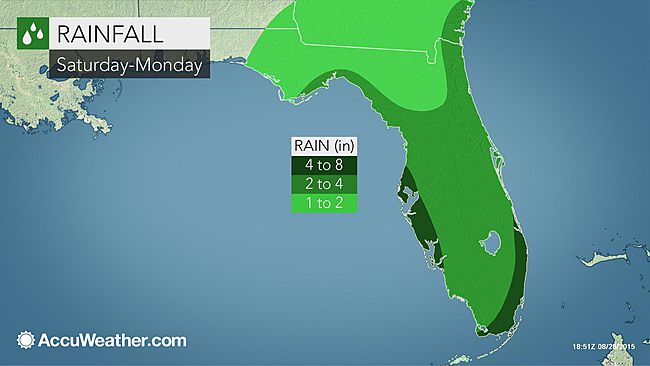
AccuWeather Forecasts have put up their rainfall forecast from Saturday and Monday. Areas that will be heavily impacted will receive upwards of 8 inches of rain. Extreme south Florida will be happy to receive this rain… Tampa really does not need this at all.
Florida now is the time to prepare. Just because it is a weak tropical storm does not mean that you should ignore it. I cannot stress enough to stay out of the water. No matter how great a surfer/swimmer you are it is not worth risking your life. Rip currents will be severe across all of Florida for the next several days as Erika approaches. Just stay out of the water, including rivers! Every year I stress this and every year I still get death statistics landing on my desk.
I advice everyone to fill their cars with gas so that they can leave if they have to. Also, please stock up on fresh bottled water and canned foods. If your community is flooded you may not receive help for a few days. Make sure you have your stash of medications and have battery operated devices such as a NOAA weather radio and flashlights. Also, don’t forget about your pets. Do not leave your pets alone in the house if you are asked to evacuate! Take your pets with you or at least board them inland. If you have to you should board your pets now and not at the time you are asked to leave. Many veterinarian offices and kennels will be happy to help evacuate your animals. Don’t leave your best friend and family members alone!
So Florida, get ready especially the Tampa area. I am very worried about how much rain Tampa has received this summer and Erika will just make this situation worse. Now is the time to prepare. So get off of this blog and start preparing!
Erika Continues to Hold On
August 27, 2015 10:02 pm EST
Erika is holding together as she approaches closer to the island of Puerto Rico. Erika crossed the northern Leeward Islands during the overnight hours and brought large amounts of rain and flooding to the islands. Canefield, Dominica, received a total of 12.70 inches of rain in the last 24 hours from Erika. At least 4 people are confirmed dead in Dominica. Three of the deaths were due to a mudslide in the southeastern part of the island. Currently 80% of the island is without power and water. Incoming and outgoing flights are canceled as the airport remains closed.
Erika now has her sights set on Puerto Rico and is currently impacting the island nation tonight and tomorrow. Tropical storm warning are already up for the Virgin Islands, Puerto Rico, and northern Dominican Republic. Puerto Rico is in some desperate need of rain due to the ongoing drought. This rain should help the island nation, however, the island has mountainous regions which will be susceptible to landslides and mudslides from the rain.
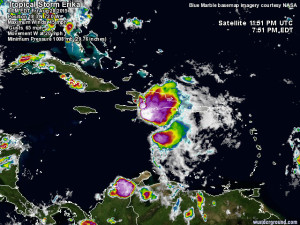
Erika is not a healthy storm at the moment. The Hurricane Hunters have been flying into this system for the past few days to gather data. Erika is still producing Tropical Storm strength winds but the pressure has been rising. This is a sign that Erika is becoming disorganized. As of yesterday (August 26, 2015) Erika had a pressure of 1003 mb, now it is 1008 mb.
(Courtesy of WeatherUnderground)
Looking at satellite and vapor imagery above Erika is struggling to hold together. The northern part of the storm is being sheared and the convective thunderstorms have started to dissipate. This is all thanks to high wind shear values coming up from the southwest.
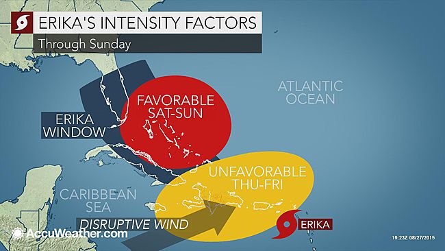
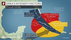
Erika will continue to be in this unfavorable area until Friday night where she will exit into the Bahamas and be in an area with very minimal wind shear and very warm sea surface temperatures. All ingredients to intensify Erika. The main concern that we have is the impact on the United States. Florida has been in the cone of uncertainty for a couple of days now. As of this morning, Georgia and South Carolina have now been included. Models are in agreement that Erika will be turning northward and following up the east coast of Florida. There is still a chance that Florida could receive a direct landfall as this storm brushes the coast (beware Titusville, FL).
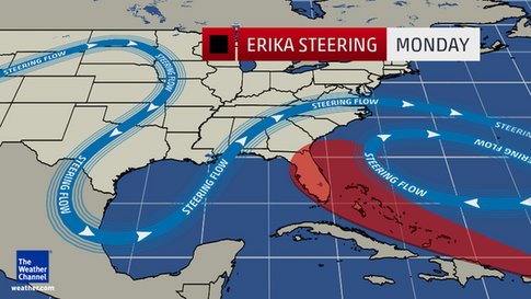

Two atmospheric components are steering Erika into this zone. The first is the jet stream which is situated very south right now. This is also the reason northern states are feeling chilly weather lately. The jet stream acts as a barrier and directs hurricanes away from the stream. Erika cannot pass through Florida or go into the Gulf of Mexico because of this barrier. The second component is the Bermuda high. This high pressure system is situated to the west, off the Carolinas. This pressure system is the same as the jet stream and acts as a barrier trapping Erika to the south and providing very little room for Erika to squeeze through.
The next 24 hours will be critical for Erika. If she manages to stay together she will exit into the Bahamas and strengthen. A strong Category 1 hurricane is being forecasted by the time Erika moves up the Florida coast (Monday – Tuesday). Georgia and South Carolina should be on alert for a potential landfall Wednesday morning. Florida, you are not out of the clear. The strongest part of a hurricane is found on the northwest side of the storm. This area, on average, contains the highest storm surge and thunderstorm activity. Stay out of the water and move inland to avoid the storm surge.
Is Erika the One?
August 25, 2015 7:32 pm EST
Round two for August. Erika is now a tropical storm in the Atlantic Basin tracking in the same direction as Danny (now dissipated). Erika is currently moving westward at 20 mph and is expected to impact the Leeward Islands in the next 24-32 hours. Tropical Storm Watches have already been posted for the islands.
So why are we so worried about Erika? To begin, it is following the same track as Danny. The energy from previous Hurricane Danny is basically being “sucked up” by Erika, allowing Erika to grow. Also, unlike Danny, Erika is a larger storm. Therefore, it will not be sheared apart as fast as a smaller storm, like Danny. At the moment Danny is looking a little disorganized, especially on the northwest side of the storm. The upper level winds in the atmosphere are tearing this part of Erika apart. However, Erika will be entering into an area of minimal wind shear in the next few hours and this will become a problem.
The National Hurricane Center released their forecast for the next few days on Erika. Florida is now in the “cone of uncertainty.” If Erika continues to hold together (which it will likely), numerous models are in agreement that Erika will not only head straight for south Florida but it will be strengthening into a hurricane (forecasts are calling for a Category 1 storm).
The track of Erika is basically set in stone. This is because The Bermuda High pressure system is keeping Erika to the south and not allowing the storm to turn back out to sea. We also have the jet stream dipping down very south for this week over the Gulf of Mexico, this will also block Erika from moving into the Gulf. Therefore, this storm has nowhere to go but into the Bahamas and Florida

Now let’s take a look at what is going on for Sunday and Monday (August 30-31) when Erika is supposed to be threatening Florida:
Above are two models. To the left we have the GFS model (American Model) and on the right we have the ECMWF model (European Model). The GFS model shows that the center of Erika will be lingering off shore from Florida and will be a weaker system (possibly just a tropical depression or storm). The ECMWF model makes all of our stomaches hurt. This model shows that Erika will become an intense hurricane and head up the east coast into the Carolinas. Both of these forecasts are completely different with regards to the strength of Erika for next week.
My own personal thoughts on Erika is that it will continue on this westward track and slowly strengthen to a Category 1 hurricane close to Florida. At the moment I do not see Erika crossing over Florida if it does impact, instead it will brush the east coast and travel NNE, possibly impacting northern Florida, Georgia, or the Carolinas. The main threat, regardless of a direct hit, will be the swells from the storm all across the shores of Florida. Rain will also be a concern, however, south Florida is currently is a drought and is desperate for some rain. Erika could help relieve this dry spell which will be good news.
I will continue to track the storm and give up-to-date information of where Erika is going. In closing, it has been 10 years since a hurricane made landfall in the state of Florida. Many have become complacent and are not ready for a hurricane. Hurricanes have devastated Florida and will continue to happen in Florida. Be prepared now, and do not wait until the last minute. Take every storm seriously. You do not want to regret not being prepared!
The First Major Hurricane of the 2015 Atlantic Hurricane Season
August 21, 2015 4:47pm EST.
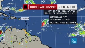
The National Hurricane Center has upgraded Hurricane Danny to a Category 3 storm at the 2:00pm advisory. Danny now has sustained winds of approximately 115 mph as it continues on its WNW track across the Atlantic. Pressure has dropped to 974 mb. Danny will continue on this path for the next few days as it impacts the Windward Islands and then move on towards Puerto Rico.
(Photos Courtesy of WeatherUnderground)
Over the next few hours Danny will be having a tough time holding together as it enters into an unfavorable area of development. Looking at the Water Vapor Satellite (a) Danny will be heading towards the orange and red areas shown. These areas are where very dry air is located which will “choke” the storm and prevent further strengthening. Along with the dry air Danny will be experiencing an area in the Atlantic with high upper level shear values (b). Currently Danny is located in the blue areas (minimal shear), but over the next few hours it will be entering the pink and red areas (very high shear values). These winds will help rip apart the storm and allow dry air to enter further into the storm. This combination will weaken Danny considerably. However, the Windward Islands as well as Puerto Rico are preparing for this storm. By the time Danny approaches the islands we will probably be experiencing a Category 1 system.
a.) 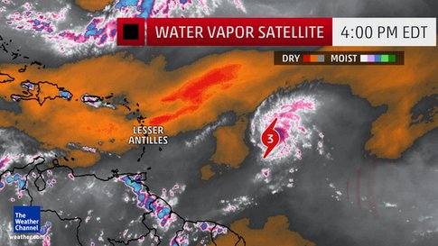 b.)
b.) 
(Photos Courtesy of WeatherUnderground)
I have said this before, Danny is located very south in latitude. This allows the storm to have a better chance of reaching the Caribbean and the Gulf of Mexico. Depending on the incoming pressure systems, the location of the jet stream and the size of the Bermuda high by mid next week, the United States may have to be preparing for an impact. There is still the possibility of this system making a northward turn sometime next week, in which case it could impact south Florida.
Finally I end with this Satellite picture taken on August 21, 2015 18:00 GMT. Look how cute and small Hurricane Danny is! It is only a very tiny system with hurricane force winds only extending to about 10-15 miles from the eye. The diameter of the storm is only about 30-50 miles across. Very tiny and small! Because of it’s small size, this is a wind storm. Meaning most of the damage will be from the wind and not the moisture. With such a small size, Danny can’t hold much moisture.
A fun fact: Andrew was a very tiny system just like Danny and underwent a very rapid intensification in a very short time. Andrew also formed and traveled the same path that Danny has been taking (although Andrew would start to turn a bit more north by now). The point is that, tiny storm like Andrew and Danny should be respected despite their size.
We will see if this system survives the dry air and the increased wind shear over the next few hours. I will continue to track the storm and bring you the latest updates on Danny.
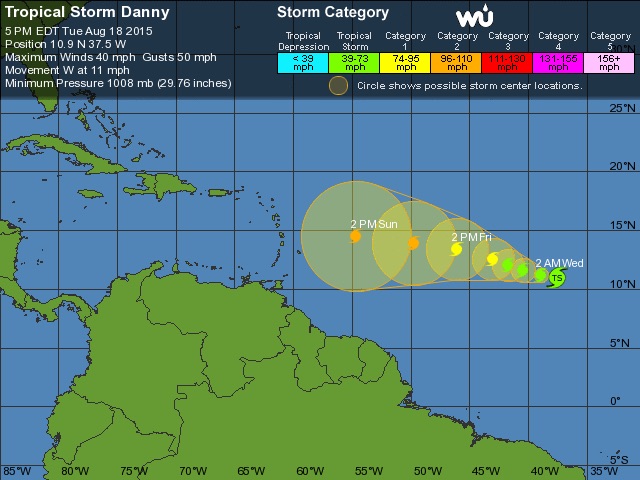
Hello Danny Boy
August 19, 2015
Yesterday the National Hurricane Center has upgraded a disturbance in the mid-Atlantic to Tropical Storm Danny. At the moment this storm is very disorganized but it is entering into favorable waters and an atmosphere that has less shear. Danny is expected to grow into a hurricane in the next 24-36 hours as it moves westward at approximately 12 mph. The center of circulation is very small at the moment but will become more organized. Winds are currently sticking around 50 mph.
(Photo courtesy of The Weather Channel)
(Photo courtesy of AccuWeather)
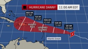
Danny will continue to travel WNW over the next few days and is expected to reach the Lesser Antilles by early Monday morning. The Lesser Antilles will most likely be issuing hurricane watches and warning by Friday and making necessary preparations. Here is the concerning part: Danny is in an area that we need to watch closely. The closer a hurricane forms to the equator the more likely this storm will cross the Lesser Antilles and enter into the Caribbean and soon the Gulf of Mexico. Models have been in agreement that Danny will continue to stay on its westward track with very little deviation.
(Photo courtesy of Weather Underground)
Starting early next week we will have a better idea on where Danny will be going and if it will possibly impact the United States. The major concern is that this storm is entering a favorable area for development. This has been a very quiet season, in part because of el Niño. However, this does not mean that we should ignore this Hurricane Season. Hurricane Andrew (1992) was the first storm of the 1992 Hurricane Season and it formed very late into the season (late August, the same time as now). No matter what we should all be prepared.
Luckily for those of us living along the Atlantic coast, our friends over in Asia (especially Taiwan) are having a horrible season so far. Two weeks ago Taiwan was experiencing Super Typhoon Soudelor, and now it looks like they will have to deal with a second typhoon! Typhoon Goni (located on the left of the picture below) is growing and increasing in strength as it continues westward. Going is currently a Category 3 storm but is expected to increase to a Category 4 storm over the next 12-24 hours. Goni will be turning northward by early-late Friday and brush Taiwan. However, the island nation will still feel the effects from this large storm, especially the east side of the island. Luckily the majority of the population on the island is located along the west side of the island.
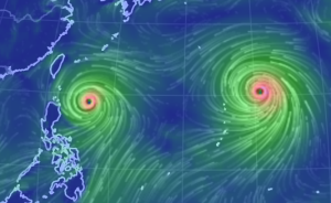
Following closely behind Typhoon Goni is a much larger storm: Super Typhoon Atsani. This typhoon is currently a Category 4 storm but is expected to reach Category 5 strength very soon. Atsani has been “feeding” on the outflow coming from Typhoon Goni over the best few days and this has helped this storm evolve to the monster that it currently is. The good news is that Atsani is not heading towards land at the moment. Unlike Goni, Atsani is heading northward and is expected to remain out at sea. Therefore, this storm will only be affecting air traffic routes and shipping traffic for the next few days.
I wil continue to monitor Tropical Storm Danny and give an update on where the storm is going!