Climate Change
A la Niña Could be Around the Corner
March 26, 2016 at 9:45 pm EST
It’s been a rough winter for some and a rather pleasant winter for others. Now the pattern is going to switch and just in time for summer. For the past few weeks climatologists, oceanographers and meteorologists have been keeping their eye on the warm blob of water off the west coast of South America (the reason for the el Niñ0 event). Scientists are concluding that the warm sea surface temperatures are rapidly cooling indicating a la Niña event may be around the corner. A la Niña event is the opposite of el Niño both in name and in temperature. Ocean waters become cooler than normal off the west coast of South America causing dryer weather in South America. The warm waters shift towards Asia bringing powerful long-lasting Monsoons to the Asian and Australian continents (wet weather).
el Niño la Niña

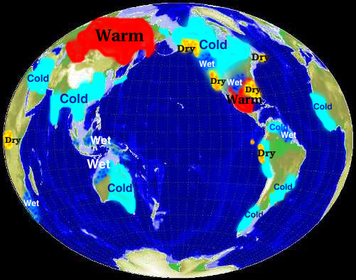
(Courtesy of NOAA Climate Prediction Center)
This change may be a relief to some, but la Niña causes extensive damage and casualties in the Southern hemisphere in particular. Southern Asia suffers greatly from this event and can expect to see higher amounts of precipitation which increases the likelihood of landslides and mudslides. Also, if you were in Canada enjoying the mild winter this year, start preparing for next winter. Although western Canada and the United States will experience chiller temperatures these cold temperatures will affect central Canada as well. Most of Canada can expect an increase in precipitation as well.
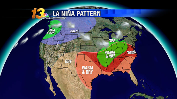
(Courtesy of NOAA)
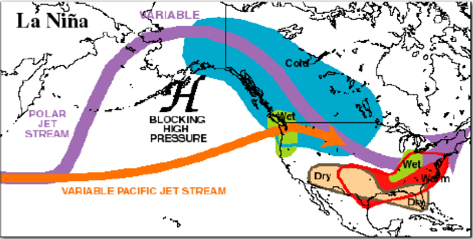
The southern United States will have the opposite problem. If you want really high temperatures (above normal) then start heading down south. Most of the southeastern states will be experiencing temperatures above normal. The downside is that there will be little precipitation to cool off the heat. Most of the precipitation will be secluded around the Appalachian Mountains and the eastern central plains. This all has to do with a blocking high pressure system which, during a la Niña event, situates itself off the coast of western Canada. The large high pressure system plays a large role in where the jet stream bends and curves. The jet stream is usually the main driver of low pressure systems (rain). The jet stream picks up these systems and carries them over the continental United States. With the high pressure system situated off the west coast most of these low pressure systems will be affecting this area. Washington and Oregon will be the wet areas in United States and British Columbia, the Yukon, and Alberta will be the wet areas for Canada.
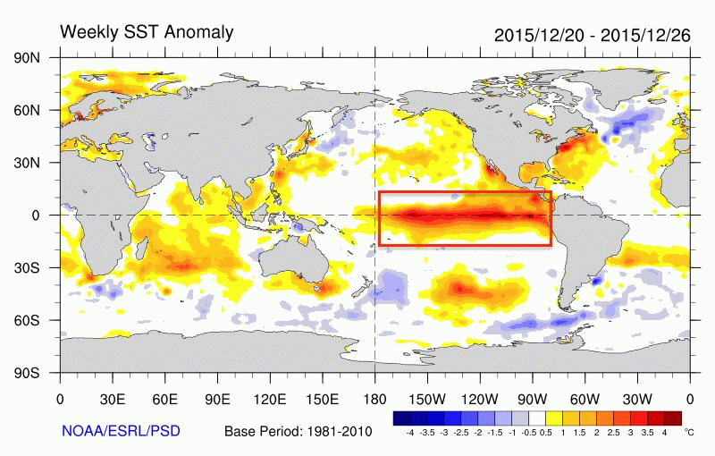
So when will this la Niña start to affect us? As usual I cannot give you an exact day or time. Sadly, climate and meteorology is not that easy. Currently we are still in an el Niño state, however it is weakening considerably as seen from NOAA’s timeline (darker red starting to fade and disappear):
We are expecting this trend to continue into the summer and we will have a short period of la nada (normal). This will only last for a couple of months before the red area shown above is replaced with blue colder waters. Therefore, by Autumn we should be receiving our first la Niña warnings. Winter will be the season where the world will be feeling the full power of a la Niña event, at least this is what I am forecasting. In the meantime, this weakening el Niño will continue and this could affect something very important in the coming weeks: hurricane season. For more information on my forecast regarding hurricane season 2016 head on over to the 2016 Atlantic Hurricane Season Blog for my forecast.
Let’s Talk “el Niño”
August 23, 2015 at 11:38 pm EST
Most of you have probably heard about the strong el Niño that is being forecasted for the fall and winter seasons this year. However, what exactly is an el Niño? The simplest explanation is that it is a warm phase that takes place in the Pacific Ocean. Ocean sea surface temperatures begin to warm off the west coast of Central and South America. So why are we so worried about this? Even though the waters in the east Pacific are warming this affects change affects the whole world.
I will be focusing on what will happen in North America over the next few months. Currently, forecasters have released their primary statement regarding the strengthening el Niño:
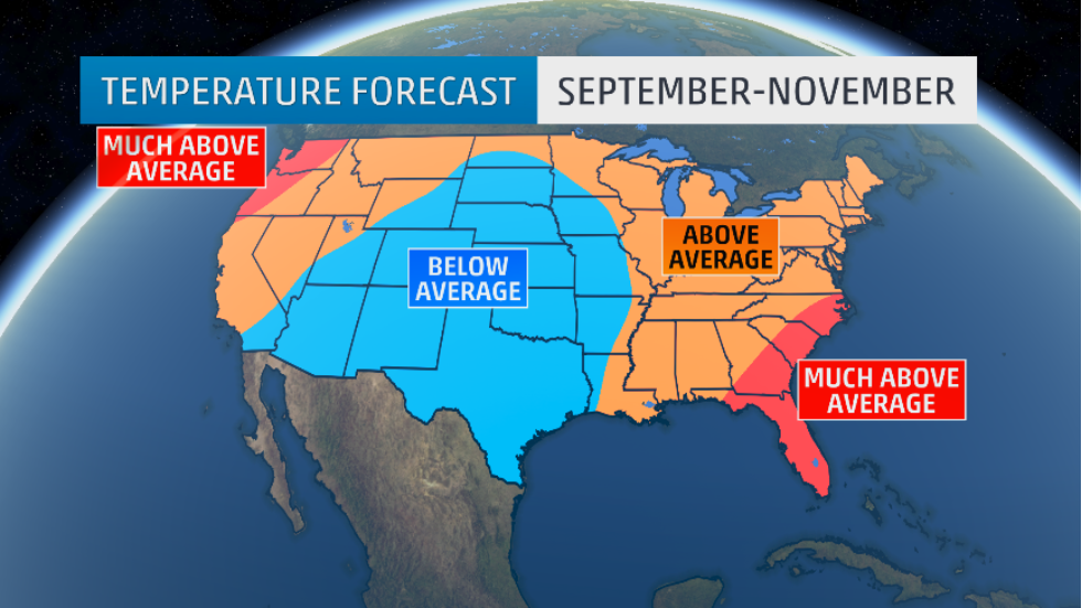
(Photo courtesy of weather.com)
After the past couple of winters, many people living in the New England area and even Canada will be breathing a sigh of relief looking at this forecast. The majority of the United States will be experiencing above normal temperatures this fall, and this will continue into the winter months. However, the central plains extending into the southern Rockies will be experiencing lower temperatures. Many may welcome this, especially with the high temperatures that have been occurring over the past few months this summer.
What about our friends to the north in Canada?
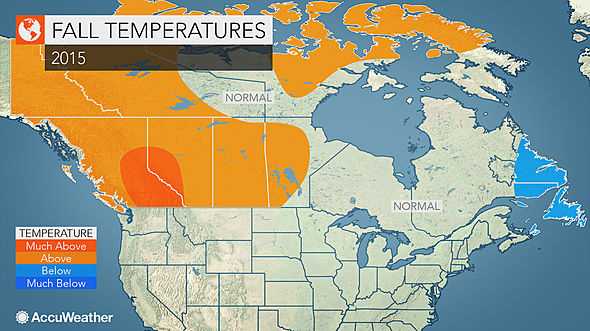
(Photo courtesy of AccuWeather)
el Niño does not just make the temperatures go crazy, it also changes precipitation values. The southern United States stretching from central California to Maryland will be getting increased amounts of precipitation. Florida will experience the most precipitation out of any other states. This could help the drought situation happening on the east coast of Florida. California should also be happy to receive an increase in rain, especially with the historical drought that is occurring.
Areas around the Great Lakes will be seeing less precipitation as well as the northern Rockie Mountains and the northern plain states. Idaho and Montana will experience the least amount of precipitation.
Similar to the United States the majority of Canada will be experiencing above normal temperatures for the fall season. The only province that will be feeling the chills will be Newfoundland and Labrador (small part of northern Nova Scotia as well). Newfoundland and Labrador have already been experiencing a chilly summer with many people wondering what happened to the summer. Even meteorologists are being arrested, being blamed for the “missing summer” (obviously they are not really being arrested), just check out the hilarious link:
Regarding precipitation for Canada: the majority of the country will be relatively normal. We will be expecting a higher amount of precipitation in northern British Columbia and most of the Yukon. Also, northern areas of Alberta, Saskatchewan and Manitoba will see more rain this fall. Finally, Newfoundland will probably experience record amounts of rain and snow. Below average precipitation values will be secluded to southern British Columbia and the majority of central and southern Ontario and Quebec (bad news for me since I love rain).
Finally, I end with Hurricane Season. Why has Hurricane Season been so quiet this year in the Atlantic and so wild in the Pacific? Just take a look at all the activity that is occurring in the Pacific compared to the Atlantic:
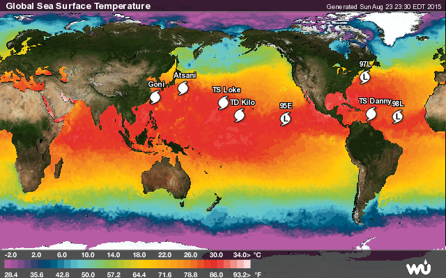 <- as of August 23, 2015
This is all thanks to el Niño. Hurricanes need warm ocean temperatures and an area of minimal wind shear, to name a few components. During an el Niño year the Pacific Ocean waters warm considerably and atmospheric wind shear decreases significantly across the Pacific. This allows for an increase in hurricane frequencies. Hurricanes continue to form and last longer in the Pacific and can grow to “Category 5” and “Super Typhoon” status. Bad news for anyone in the Pacific. Especially over in Taiwan and Japan. However, in the Atlantic el Niño does the exact opposite. Instead of ocean sea surface temperatures becoming warmer in the Atlantic, they grow colder. A very bad sign for hurricanes. Without warm waters a hurricane cannot form and thus we experience a quiet Hurricane Season. This does not mean that hurricanes do not form, it just means we will see less hurricanes forming during an el Niño year. At the moment, the tropics are becoming more active (mostly due to the fact that we are approaching the peak of Hurricane Season). Behind Danny, which is weakening very rapidly, there are two tropical waves which have the potential to turn into tropical storms very soon.
Finally, has anyone been keeping a close eye on Hawai’i these past few months? For the past few months Hawai’i has been the center of attention when it comes to hurricanes. Most years hurricanes stay clear from Hawaiian waters. Usually they will form off the coast of Central America or extreme northern South America and track westward for a few days before dissipating. These hurricanes do not reach as far as Hawai’i. However, this year Hawai’i has been threatened by many approaching hurricanes. This all has to do with the warmer sea surface temperatures and areas of very low wind shear. This allows the hurricanes to hold together and track towards the islands. Currently, Hawai’i is being threatened by Tropical Depression Kilo (which will soon strengthen as it turns northward). Kilo will more than likely miss the islands, but the fact is that these hurricanes are moving closer to Hawai’i this year compared to the average year. So who do we thank for this? el Niño.
As we enter into the fall and the winter seasons I will keep everyone updated on what will probably be a historic el Niño season which could rival the 1997-1998 el Niño season.