Natural Disasters
Japan and Ecuador Both Experience Strong Earthquakes
April 17, 2016; 11:13 EST
It has been a very busy week for two countries. Let’s start with Japan:
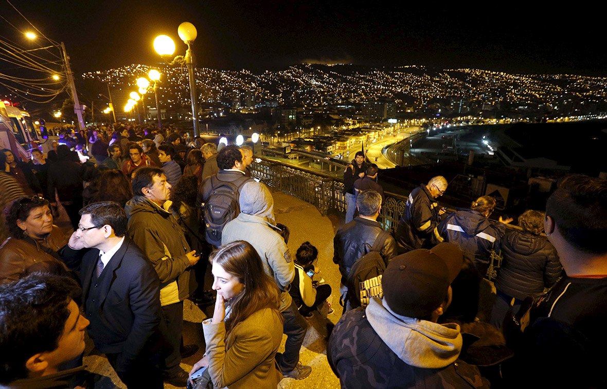
On Thursday April 14 at around 9:26 pm local time i Japan a magnitude 6.2 struck southern Japan’s Kyushu Island near Ueki collapsing structures and killing at least 9 people. Nearly 800 people were injured, 50 severely. Many of the deaths were caused by the structure collapse. Search crews immediately entered the area to rescue as many people as possible that were trapped under ruble. Dozens of smaller aftershocks occurred which continued to weaken structures that were already heavily damaged from the 6.2 quake. This earthquake was a shallow earthquake meaning that the hypocenter (underground focus point of an earthquake) was only 10 kilometers (6.2 miles) under the Earth. While a 6.2 is not very significant (especially in Japan) this shallow depth caused the extensive damage. The closer an earthquake is to the surface the more damage is expected.
As Japan began to clean up and conduct their search and rescue operations while battling with the aftershocks a 7.0 magnitude earthquake struck two days later in almost the same location. The 7.0 magnitude quake struck near the city of Kumamoto around 1:30 in the morning collapsing more structures and killing an additional 32 people (more expected). A tsunami warning was issued for the area but was soon canceled. Like the first earthquake the 7.0 was a shallow earthquake. This earthquake did additional damage to structures and even caused a massive landslide in the region. The main highway is heavily damaged causing problems for rescue operation vehicles to enter the city.


Damage photos Courtesy of CNN News
I also want to point out the roofing structure of Japanese homes in this region. Kumamoto is a very old and ancient city and its architecture goes with this. The roofs on many homes are designed beautifully but also very heavy. Most of the shingles decorating house roofs are made of materials like brick, ceramic and other heavy materials. Although this has been changing recently, these type of roofs do damage in an earthquake and cannot support themselves with the intense shaking. Most of the death this past week were caused by collapsed structures. Most people were in their homes sleeping when these two earthquakes occurred. Many people were probably crushed by their roofs falling on them as they slept.
The earthquake with a 7.0 magnitude is now known as the main earthquake event. The 6.2 magnitude earthquake was a foreshock to the 7.0 one. Earthquakes that occur after the 7.0 are now known as aftershocks.
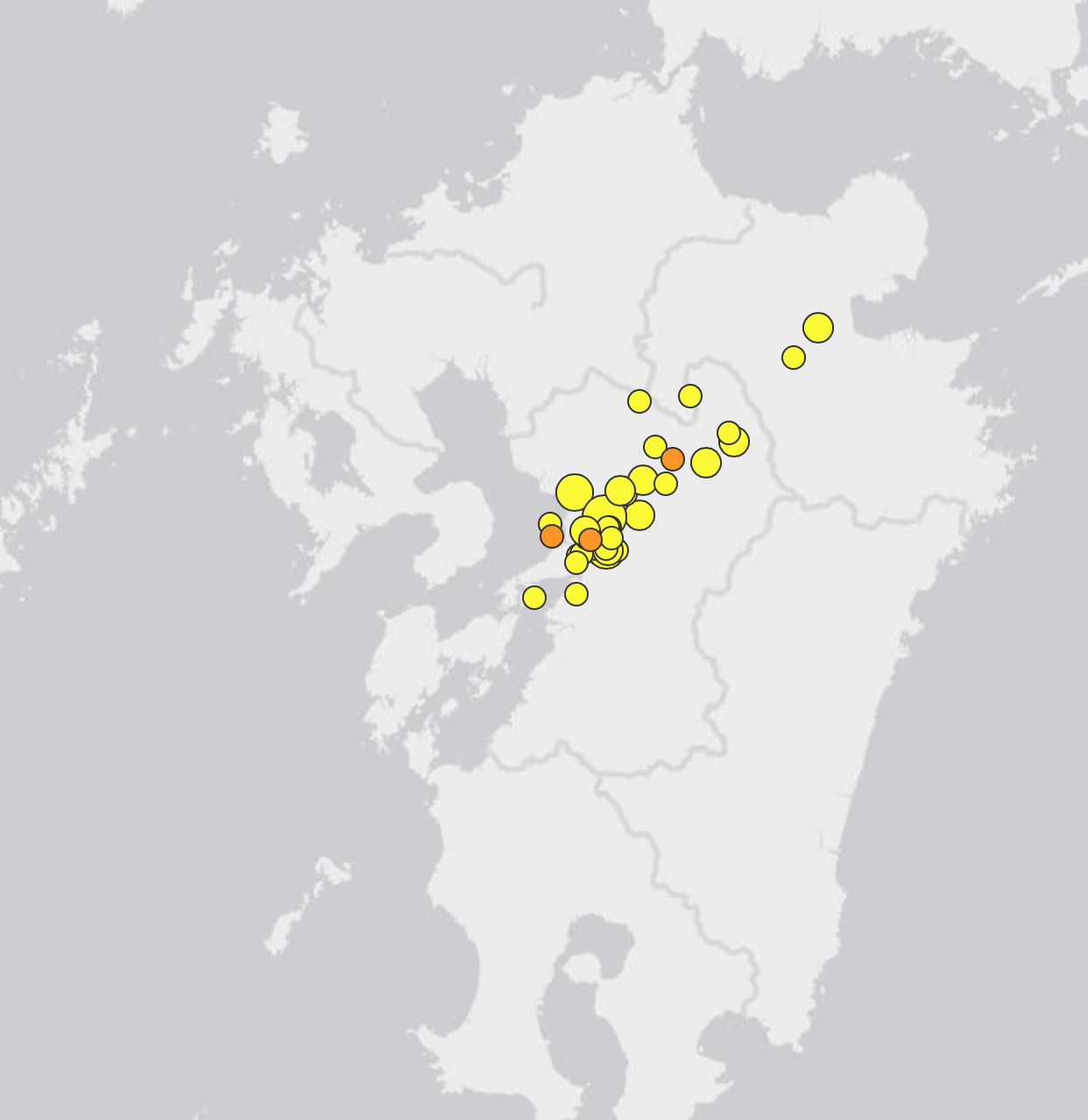
United States Geological Survey map showing the earthquakes the area has experienced since the 6.2 magnitude earthquake on April 14th.
So far 90 homes are completely destroyed and 775 are damaged. Approximately 91,700 people have been evacuated from the region in fear of more structural collapses and even the threat of volcanic activity in the area. Although uncommon, earthquakes have been known to trigger volcanic activity, especially on an active volcanic island like Japan.
Rescue efforts continue in the area but now it is a race against the clock as the area is expected to receive heavy rain from the west which will hamper rescue efforts.
The two earthquakes in Japan have so far killed 41 and injured more than 900. Famed monuments suck as Kumamoto castle have been heavily damaged and residents have been put up in shelters until repairs can be made. There are small miracles in the midst of this tragedy though. Over 24 hours after the first 6.2 earthquake, an 8 month old baby was found amongst the ruble alive and well.
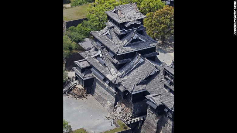

Kumamoto Castle heavily damaged (left). An 8 month-old baby girl rescued from beneath a collapsed structure (right). Photos courtesy of CNN News.
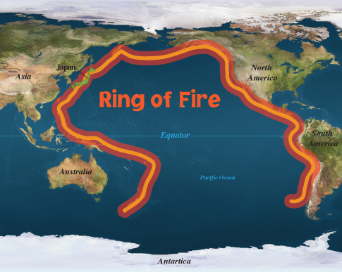
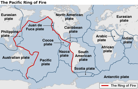
Japan is used to earthquakes, especially powerful ones. They are known to be leading country in earthquake preparedness. Earthquakes in a sense are normal to this nation as they lie along the “Ring of Fire”, a tectonic boundary that spreads along the Pacific coastlines:
However, Japan is not immune to the force of earthquakes. In 2011, a magnitude 9.0 earthquake struck off the coast of northeast Japan causing a massive tsunami to race towards the coast of Japan causing horrifying damage, a nuclear meltdown and immense loss of life. Even with early warnings 15,891 people perished. Over 2,500 continue to be missing.
Ecuador
This is the big news at the moment. On Saturday April 16, Ecuador was hit by a magnitude 7.8 earthquake at around 6:58 pm local time. About 30 minutes prior to the main event a 4.5 magnitude foreshock was experienced along the coast south of Muisne.
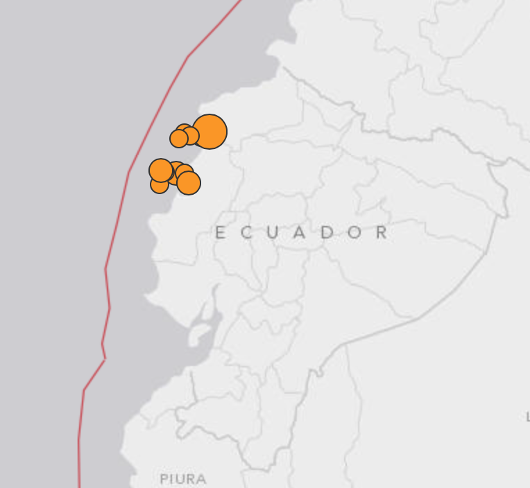
United Sates Geological Survey Earthquake map showing the earthquakes that have occurred in the region. The red line is the tectonic boundary which lies just off the coast of Ecuador.
The epicenter of the quake was located 16 miles SSE of the coastal town of Muisne on the country’s northwestern coast. Similar to the Japan earthquakes this was a shallow quake with a depth of only 19 km (12 miles) below the Earth’s surface. A Tsunami alert was immediately put out to the public but lifted soon after. Numerous structures and bridges have collapsed trapping hundreds. Landslides have also been reported hampering rescue efforts. So far 77 people are confirmed dead and this number is expected to rise in the coming days.
David Rothery, a professor of planetary geosciences at The Open University, northeast of London, says the total energy released by the magnitude-7.8 quake Saturday in Ecuador was “probably about 20 times greater” than the magnitude-7.0 quake in Japan on Saturday.
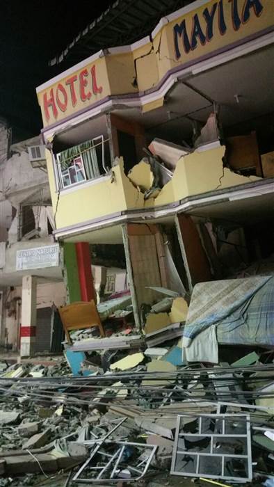
Collapsed Structures. Courtesy of NBC News.
Emergency crews are combing through the damage area to free any people trapped under rubble. Looting has broken out since the earthquake, however, authorities are preoccupied trying to save lives and do not have time to re-establish order to the area.
Power is out across the region as rescue crews are battling aftershocks (135 recorded so far) further weakening structures. Residents are advised that some of these aftershocks will be strong (one has already been recorded as a 6.0 magnitude). We should be getting more information in the coming hours as daylight returns to Ecuador.
President Rafael Correa has declared a national emergency. This is the strongest quake to hit Ecuador since 1979.
It may come as a shock to many that two countries, an ocean apart from each other, both experienced strong earthquakes. However, there is some science behind this. Like Japan, Ecuador lies along the same “Ring of Fire” boundary that Japan does:
Think of this as a giant puzzle piece. We have There is a lot of force on this puzzle piece. Over by Japan there is a “pulling” force, where the Pacific plate boundary (off the coast of Japan) is sinking underneath another separate plate which Japan is over. This creates a lot of friction and force and when it becomes too much the Earth “slips” and creates an Earthquake.
This is the same over in Ecuador:

The same Pacific plate is being pulled under the South American continent causing pressure underneath the Earth until it releases and creates an earthquake.
What usually happens, since the ring of fire is one long “crack” that goes around the Pacific, is that when Japan experienced their earthquakes it caused force on the opposite side of the Ring of Fire over in Ecuador. This additional pressure was too much on the other side of the Pacific from the Japan earthquake, thus Ecuador experienced an earthquake. It is not uncommon for this to happen, especially since Ecuador and Japan are connected by the same tectonic plate boundary (the Pacific plate). We could potentially see some smaller earthquakes along the Pacific Ring of Fire in the coming days as the plate tries to get in a more “comfortable” position. The Earth is a fascinating living structure 🙂
Death Toll Climbing in Afghanistan and Pakistan
October 26, 2015; 8:15 EST
At approximately 2:10 PM local time (5:10 am EST) a massive magnitude 7.5 earthquake struck the remote regions of northern Afghanistan near the border of Pakistan Monday October 26, 2015 killing at least 263 people. Below is a screen shot showing the approximate area the earthquake occurred and the aftershocks throughout the day.
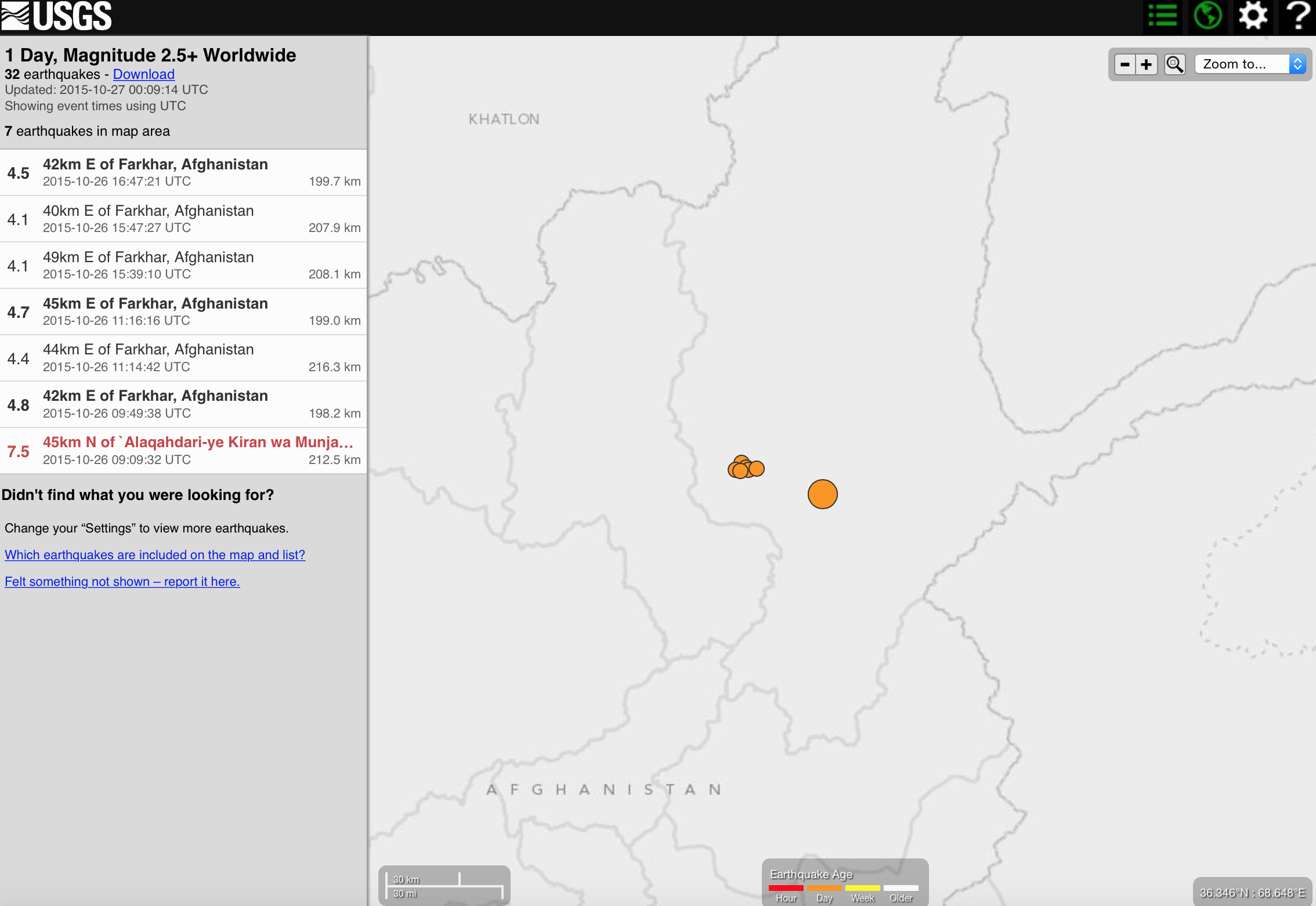
(Screenshot from the United States Geological Survey -USGS)
The shaking was intense for about 45 seconds in the Afghan capital of Kabul as ancient and poorly developed houses collapsed from the strong shaking. Pakistan received the majority of the damage with 228 people dead and more than 1,000 injured. Afghanistan has so far reported 33 deaths and more than 200 injuries.
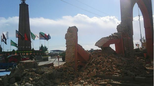
Brick structures stood no chance against the earthquake (Photo Courtesy of BBC News).
The epicenter of the earthquake was located about 73 km (45 miles) south of Fayzabad. The quake is shallow compared to previous earthquakes (particularly the deadly 7.6 magnitude earthquake which occurred on Oct. 8, 2005 and killed more than 80,000 people). This earthquake took place about 10 kilometers below the surface, the previous earthquake was 213 kilometers below. It is these deep earthquakes that usually account for more violent shaking and therefore more destruction.
Despite the climbing death toll from this recent quake the death count is relatively low at the moment (horrible to say but true). The area that was hit is one of Afghanistan’s poorest provinces. Due to the tectonic activity of the Indian plate colliding with the Eurasian plate this area experiences a lot of earthquake activity. However, this area is not very populated and this helps the fatality numbers stay relatively low.
Let’s not think that this is a weak earthquake though. The following image has been flying around social media all day showing a glacier in Hunza falling down due to the earthquake:
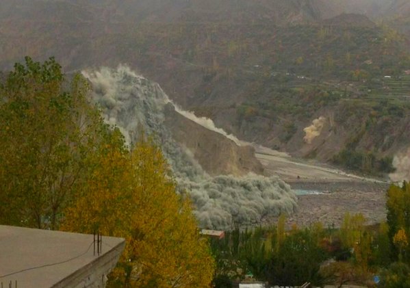
(Photo from SkymetWeather Twitter Account)
Authorities have been working all day to get into the remote areas that have been severely impacted. Communication has been cut off since the quake. Authorities and geologists warn that landslides are still a huge threat since the earth may have become dislodged in some areas, especially in the mountain regions. Aftershocks have been hovering around the 4.1 to 4.8 magnitude range. A few landslides have already been captured:
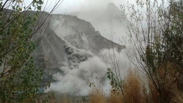
(Photo courtesy of BBC)
Fatality rates are expected to increase as authorities make their way into more areas that have been devastated.
Chile Shaking
September 18, 2015; 12:53 pm EST
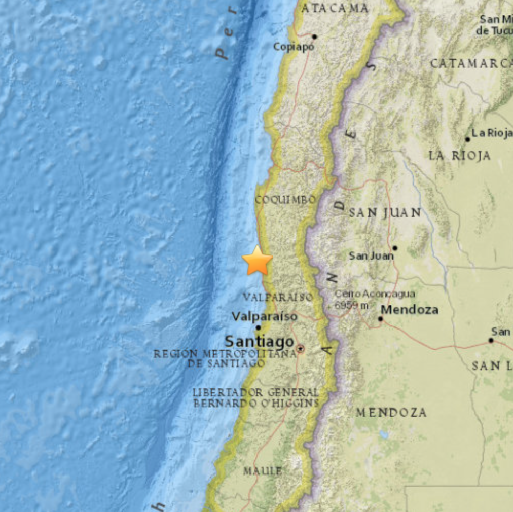
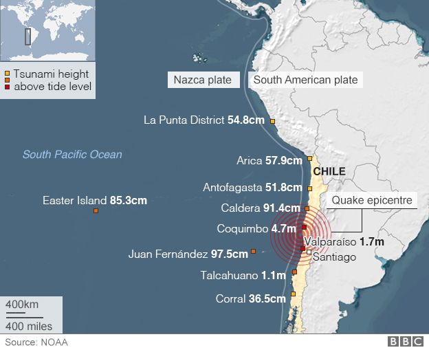
A powerful earthquake struck off the west coast of Chile Wednesday September 16 at approximately 22:54 UTC time (19:54 Local Time). The earthquake measured a powerful 8.3 on the Richter Scale. The earthquake was center approximately 46 km (29 mi) west of Illapel, Chile or 229 km (142 mi) north-northwest of Santiago, Chile. About 1 million people were evacuated from the earthquake area in fear of an approaching tsunami.
(Photos courtesy of the United States Geological Survey and BBC News)
A Tsunami warning was issued for the entire coast of Chile immediately following the earthquake. Tsunami advisories and alerts were also issued for southern California, Hawaii, Japan and even as far away as New Zealand. Residents of Illapel (closest to the epicenter of the earthquake), fled their homes in fear that they would be swept away by the approaching waves. The coastal town of Coquimbo, Chile recorded waves of 4.7 m (about 15 ft), this is so far the largest recorded waves so far from the tsunami. The city of Illapel was among the worst hit. Many structures have been damaged and have collapsed. Thousands of residents in the area are still without running water or electricity. Currently, 11 people are confirmed dead from the earthquake, this number is expected to rise in the coming days.
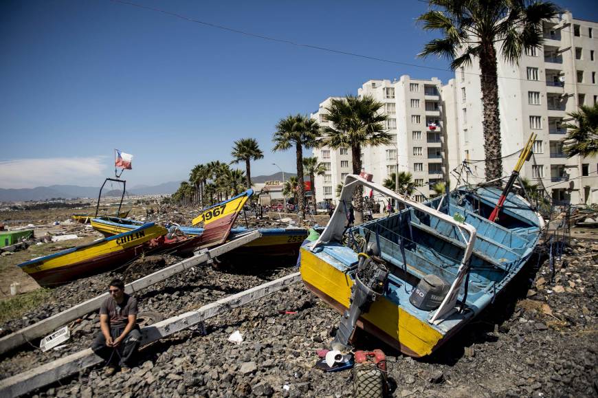
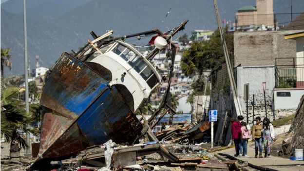
(Photos courtesy of BBC News)
Chile’s government has declared a state of emergency in the areas affected by the earthquake and tsunami. This earthquake, so far, ranks as the sixth most powerful earthquake on record for Chile.
Elsewhere in the world, other countries scrambled to get the word out to their citizens that a tsunami was approaching. The west coast of the United States and Canada received small tsunami waves. Hawaii recorded a 1 m (3 ft) wave. Japan received the tsunami waves on Friday morning where authorities issued a tsunami advisory. The Japanese coastal port of Kuji received a wave of approximately 70 cm. This was the same area that the deadly 2011 Japan Tsunami struck. Smaller waves were also detected across Japan’s east coast. There have been no confirmed damages or injuries in countries outside of Chile.
 Approximate time distribution of the tsunami wave.
Compared to other earthquakes of similar magnitude, the death rate remains low for Chile. This is due in part to the country being in a seismically active area. The residents of Chile are no strangers to earthquake, especially powerful ones like the one they just experiences. Chile lies on a very active fault where two plates are coming together, known as a convergent boundary. The eastern edge of the oceanic Nazca Plate is being subjected under the South American continent (known as the South American Plate). These two plates are creating intense pressure on each other that earthquakes are very common in this area. Due to the fact that this process is taking place right off the coast of Chile, when an earthquake does occur the water above is displaced and moves outward at high speeds (For more information on earthquakes of tsunami this is a helpful reference). This is the tsunami that millions along the coast fear.
The residents of Chile have been through enough earthquakes and tsunamis to know how to protect themselves. Many photos are circulating online showing residents racing to higher ground to avoid the large tsunami waves such as the one below.
The people of Chile know their evacuation procedures very well and this explains the relatively low loss of life. Another factor that played in Chile’s favor was the time that this earthquake occurred. The earthquake occurred at close to 8pm when most people were home and getting ready for bed. If this earthquake occurred a few hours sooner the death rate may have been higher. More people would have been in rush-hour traffic or working.
Chile will continue to clean up and rebuild from this devastation. They have done it millions of times before and they will continue to become a nation that is prepared when it comes to earthquakes and tsunamis, because this event will occur again and again, sadly. This is all thanks to the convergent plates boundary just offshore. That plate boundary is just building up more pressure for the next big one.
My final note on this topic is directed at the media covering this disaster. I must say I am disappointed by the lack of coverage regarding this disaster. Many people along the west coast of the United States did not even get word of the earthquake or the approaching tsunami until after everything was over. More focus was geared towards the upcoming elections in the United States… I guess many do not realize that a president is not going to save us from a natural disaster. Natural disasters will destroy us before we destroy them. The elections can wait, peoples lives come first.
One Comment
Cedric
Thanks, it’s very informative